Gulf disturbance will bring heavy rain to the Miami area. When to expect the worst
Bottom line from the National Weather Service in Miami: South Florida is facing two to four inches of heavy rain and flooding that could top six inches every afternoon this week through at least Saturday.
As a result, the srevice’s Weather Prediction Center put South Florida under a “Marginal Risk of Excessive Rainfall” alert effective Wednesday through Saturday.
Keep your umbrella close by the rest of the week as the rain chance remains high due to tropical moisture from the Gulf. Widespread storms likely with the potential for heavy rain & flooding. @CBSMiami pic.twitter.com/2GoqLSvrHj
— Lissette Gonzalez (@LissetteCBS4) May 31, 2023
WSVN meteorologist Vivian Gonzalez reported a funnel cloud over the waters of Fort Lauderdale beach at 10:30 a.m. Wednesday. The weather service issued a special marine warning for the nearshore waters until 11 a.m. for potential waterspout activity.
5/31 at 10:30am: Funnel cloud has been reported just offshore of Fort Lauderdale Beach. A Special Marine Warning has been issued for the nearshore waters until 11am for potential waterspout activity. https://t.co/GcShX6IgpB
— NWS Miami (@NWSMiami) May 31, 2023
Flood watch
And Sammy Hadi, a meteorologist with the weather service, issued a flood watch Wednesday afternoon that will remain in effect until Friday evening because of expected rounds of rain.
Affected areas include:
▪ Coastal Miami-Dade, Broward and Palm Beach counties.
▪ Far South Miami-Dade County.
▪ Inland Miami-Dade, Broward and Palm Beach counties.
▪ Metro Miami-Dade, Broward and Palm Beach counties.
▪ Glades and Hendry counties.
5/31 @ 12:00pm: A Flood Watch has been issued for Miami-Dade, Broward, Palm Beach, Hendry, and Glades counties through Friday evening. While most of us will see rainfall amounts of 2-4 inches through the end of the work week, a few spots could pick up higher amounts of 6+ inches. pic.twitter.com/paWhlnu217
— NWS Miami (@NWSMiami) May 31, 2023
What is causing the rain in Miami and Fort Lauderdale?
Hurricane Season begins tomorrow & I'm tracking an area of low pressure in the Gulf of Mexico that has a low chance of development and is disorganized. Regardless of development, this disturbance will lead to heavy rain & flooding for #SouthFlorida the rest of the week. @CBSMiami pic.twitter.com/TDDAmcPieP
— Lissette Gonzalez (@LissetteCBS4) May 31, 2023
Blame an upper level low over the Gulf of Mexico slowly approaching Florida near the end of the week that’s bringing all this mess from south of Lake Okeechobee to the Miami and Fort Lauderdale areas, meteorologist Ana Torres-Vazquez said in the weather service’s Wednesday morning report.
Some of the thunderstorms could contain strong and gusty winds, along with frequent lightning strikes
Lissette Gonzalez, CBS News Miami meteorologist, says most of the stormy activity will start in the late afternoon hours, and linger through the evenings.
For instance, overall average rain chances for the Miami-Fort Lauderdale areas are 30% pre-afternoon, rising to 60% in the afternoon and 80% at night.
Thursday is looking like a 60% rain chance during the day and 80% in the afternoon and evening hours. Friday is a soggy 80% all day, and Saturday is a 60% and 40% mix.
Wettest times of the days
Sports fans don’t have to worry about storms soaking their drives to Miami Heat or Florida Panthers games. Both team start their series finals out of town.
But Miami-Dade and Broward public schools are still in session for another week. The times you may be picking up your students, or leaving work, are the worst, according to the weather service’s 48-hour hourly outlook concerning rain.
Here are details:
4 p.m. Wednesday: 54% rain and storm chance.
7 p.m. Wednesday: 78% storm chance. Then chances drop overnight to its lowest point — 19% to 17% between 1 a.m. and 4 a.m.
Then the rain starts to surge again steadily increasing Thursday.
10 a.m. Thursday: 63% rain.
1 p.m. Thursday: 78%.
4 p.m. through 7 p.m. Thursday: 82%.
10 p.m. Thursday through 1 a.m. Friday: 74%.
4 a.m.-7 a.m. Friday: 66%.
10 a.m. Friday: 83%.
The rain eases Sunday and Monday at 30%.
The Florida Keys won’t escape wet weather but the chances aren’t as acute as in Miami-Dade and Broward: 50% Wednesday, 60% Thursday, 40% Friday, 30% Saturday and 20% Sunday.
The Gulf trough
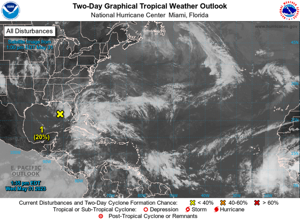
Here’s what National Hurricane Center specialist Philippe Papin said in the center’s 2 p.m. Wednesday report about the trough in the Gulf:
▪ An area of low pressure has formed over the northeastern Gulf of Mexico in association with disorganized showers and thunderstorms displaced to its northeast.
▪ Environmental conditions appear marginally favorable for some slow development over the next day or two as the system meanders over the northeastern Gulf of Mexico. Formation chances are low at 20% into Friday (a bump up from 10% at 8 a.m. Wednesday).
▪ After its meandering, by this weekend environmental conditions are forecast to become unfavorable for additional development as the system drifts southeastward towards the Florida Peninsula. Formation chances over a week’s time remain still low at 20%.
▪ “Regardless of development, the system could produce heavy rainfall and gusty winds over portions of the Florida Peninsula through this weekend,” Papin said in his report.
▪ The storm system is the second reported so far in 2023, days ahead of the June 1 start of the 2023 Hurricane Season.
Hurricane Season 2023
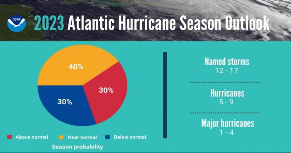
Last week, the National Oceanic and Atmospheric Administration released its official prediction for the upcoming hurricane season and said it could be quieter than usual, with a 40% chances at a “near normal” season and a 30% chance of either a below-average or above-average season: 12 to 17 named storms, five to nine of which could develop into hurricanes and one to four that could strengthen into powerful Category 3 or stronger storms.
The agency predicts there’s a 40% chance of a near-normal season and a 30% chance of either a below-average or above-average season.

