The Gulf of Mexico is hot. Could that help produce another Hurricane Katrina?
Extremely hot weather has plagued Mississippi and the South this summer with some temperatures breaking records and waters of the Gulf of Mexico are heating up, too.
With the peak of hurricane season just around the corner, are conditions setting up for the possibility of another Hurricane Katrina?
"The ocean itself, the Gulf of Mexico, is very favorable for a hurricane," said Johna Rudzin, Mississippi State University Department of Geosciences assistant professor. "It's a question of if the atmospheric conditions are favorable enough to sustain a hurricane."
It's somewhat like a battle between the current El Niño weather pattern and above average water temperatures and according to Rudzin, it's unclear which side will win.
The effect of El Niño on hurricanes
"The main component for the Atlantic and the Gulf of Mexico is increased vertical wind shear the El Niño produces," Rudzin said. "It helps disrupt the storms.
"It's not just about the ocean. The wind shear is one of the most significant factors."
While they aren't felt at the surface, Rudzin said there are strong vertical winds aloft that are associated with El Niño and they can prevent a storm from reaching its full, destructive potential by causing disorganization.
But El Niño doesn't always prevent a monster hurricane from forming. Hurricane Katrina formed during a mild El Niño weather pattern.
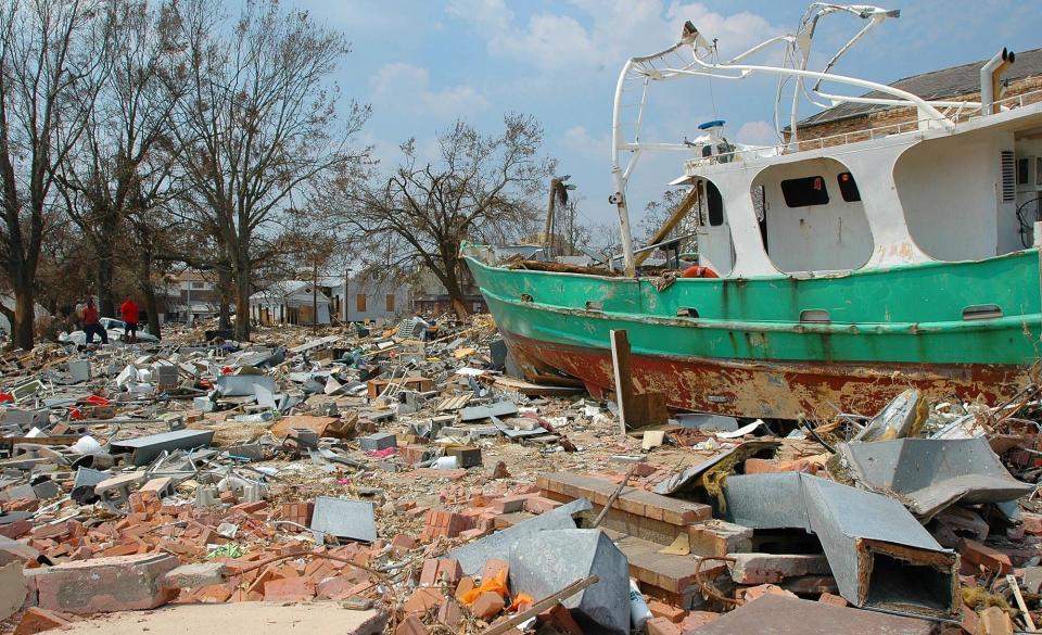
Looking back at Hurricane Katrina
On Aug. 24, 2005 a tropical depression in the central Bahamas became Tropical Storm Katrina. It made landfall in southeast Florida the following day as Category 1 Hurricane Katrina. When it entered the Gulf of Mexico, the warm water allowed Hurricane Katrina to rapidly intensify to a Category 5 with maximum sustained winds of 175 mph.
By the time it made landfall in Hancock County on August 29, it had downgraded to a Category 3 hurricane.
However, despite weakening, Hurricane Katrina caused enormous destruction. According to the National Weather Service, it took 1,833 lives and caused about $108 billion in damage. It was one of the five deadliest hurricanes to ever strike the US.
Hurricane Katrina was feeding on warm water that according to NOAA was between two and three degrees higher than normal and the moisture produced by it with temperatures similar to what they are now.
15 years ago: 5 things to know about Katrina, one of the nation's worst natural disasters
Gulf of Mexico water temperatures and hurricanes
Rduzin said the minimum water temperature needed to sustain a hurricane is about 76 degrees. According to data collection sites in the Gulf of Mexico, temperatures have well exceeded that.
"I looked at one at the dead center of the Gulf of Mexico and it was 89 degrees," Rudzin said. "That is much, much warmer."
Here are some average water temperatures for August around the Gulf Coast and those that have been recently recorded according to NOAA.
Blackwater Sound, Florida: Recent temperature - 92.1 degrees. Average for August - 88.2.
Pensacola, Florida: Recent temperature - 86.9 degrees. Average for August - 86.4.
Coast Guard Sector Mobile, Alabama: Recent temperature - 89.8 degrees. Average for August - 85.7.
Mobile State Docks, Alabama: Recent temperature - 88.9 degrees. Average for August - 85.7.
Pascagoula NOAA Lab, Mississippi: Recent temperature - 86.4 degrees. Average for August - 85.7.
Bay-Waveland Yacht Club, Mississippi: Recent temperature - 89.2 degrees. Average for August - 86.
Pilottown, Louisiana: Recent temperature - 87.3. Average for August - 86.2.
Calcasieu Pass, Louisiana: Recent temperature - 88.9. Average for August - 87.1.
Texas Point, Sabine Pass, Texas: Recent temperature - 88.5 degrees. Average for August - 86.6.
Eagle Point, Galveston Bay, Texas: Recent temperature - 87.8 degrees. Average for August - 86.3.
While there are some recent temperatures at or below average, the vast majority are above average.
More: Your ultimate Mississippi summer bucket list is right here
The Gulf of Mexico has a deeper problem
Mississippi and other southern states have seen record-breaking temperatures recently, but the overall pattern has been excessive heat for weeks.
"It has been brutal," Rudzin said. "It's just been cooking the last few months and that warmth sinks deep down into the ocean."
That causes yet another problem. Rudzin said storms over water have a churning effect and that mixes warmer surface water with cooler water below. That lowers the overall temperature and reduces fuel fuel for the storm.
When the warmth extends well below the surface, the churning doesn't cool the water as much, so there's plenty of energy for the storm. And according to models used by the National Weather Service, the above average temperatures that can cause deep warming aren't going away anytime soon.
"That places Mississippi for above normal chances for above average temperatures," said Daniel Lamb of the National Weather Service in Jackson, Mississippi. "It's been very hot over the last several days and we've had record temperatures. It's not saying we're going to continue to have those record temperatures, but above average temperatures will continue over the next few months."
Do you have a story idea? Contact Brian Broom at 601-961-7225 or bbroom@gannett.com.
This article originally appeared on Mississippi Clarion Ledger: Could the hot Gulf of Mexico fuel another Hurricane Katrina?

