Gushing rain, flooding to continue as atmospheric river slowly shifts in Northwest

As a fire hose of rain, known as an atmospheric river, continued in western Washington and Oregon, small streams and rivers became raging torrents posing significant threats to lives and property into Wednesday night.
The atmospheric river turned deadly near Portland, Oregon, on Monday, when a man was swept away along Johnson Creek. A second death was reported Tuesday after a man was recovered from Bronson Creek, also near Portland.
AccuWeather meteorologists reserve the term "atmospheric river" for the most extreme rain and snow events when a long plume of moisture is directed from the ocean to the land, and there is a risk of major travel disruptions or much more serious conditions.
"While atmospheric rivers can vary greatly in size and strength, the average atmospheric river carries an amount of moisture roughly equivalent to the average flow of water of the Mississippi River in southeastern Louisiana," according to the National Weather Service (NWS). Exceptionally strong atmospheric rivers can transport up to 15 times the average flow of the Mississippi River and can extend for thousands of miles.
 |
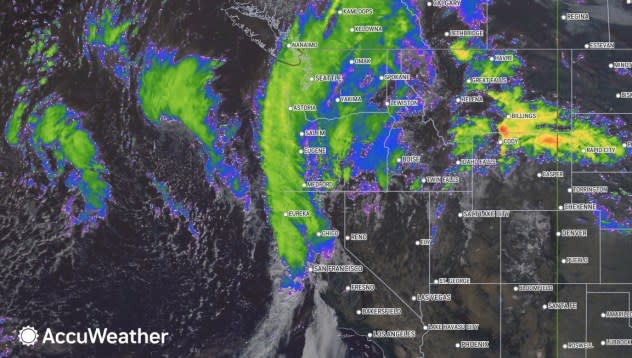
This image shows a weakening atmospheric river along coastal areas of the northwestern United States as of Wednesday, Dec. 6, 2023. (AccuWeather Enhanced RealVue™ Satellite.) |
At times into Wednesday, the rain poured down at the rate of 1-2 inches per hour in some locations. For reference, an average rainstorm may bring that amount of rain throughout its entire duration. Along with the copious amounts of rain, much warmer air is accompanying the atmospheric river, which has already led to quickly melting snow at high elevations in the Olympics and Cascades.
Storms from late last week deposited from 1 to 4 feet of snow on intermediate elevations, which was wiped out in a matter of hours by the atmospheric river.
The combination of melting snow at high elevations with torrential rain will cause small streams and rivers in western parts of Washington and Oregon to run high on Thursday. Even though water levels had crested on most streams and rivers as of Wednesday midday, dangerous conditions and flooding will continue. The banks along some streams could give way without notice due to the raging water and saturated state of the ground.
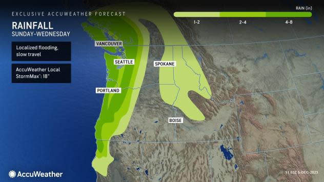
During the 24- to 48-hour period ending Wednesday night, more than a month's worth of rain had poured down for many. In some cases, this meant that 4-8 inches of rain fell, enough to lead to street and highway flooding in low-lying and poor-drainage areas. However, when combined with rapidly melting snow from the intermediate and high elevations that have occurred and will continue, the release of water may be the equivalent of 12 inches or more of rain falling. There is an AccuWeather Local StormMax® of 18 inches of rain for this event which is most likely to occur along the west-facing slopes of the Cascades, Coastal Ranges and Olympics.
 |
The sudden rainfall will cause the ground to become saturated despite prior drought conditions in the western portions of Washington and Oregon. The land may give way in some cases, leading to rockslides, debris flows and road washouts.
Travel along Interstate 5 in much of Washington and Oregon, including in the Seattle and Portland metro areas, will be slow, with torrential rain at times that will lead to poor visibility, excess water on the roads and the risk of vehicles hydroplaning into Wednesday evening.
Motorists dodging road closures due to rain and warm conditions will likely encounter poor visibility due to snow and fog with slippery and snow-covered highways in higher elevations as the week progresses in the Northwest.
After rain fell over most of the passes into Wednesday evening, enough moisture will continue to stream in from the Pacific as colder air arrives to bring several inches of snow through Thursday night in the Cascades.
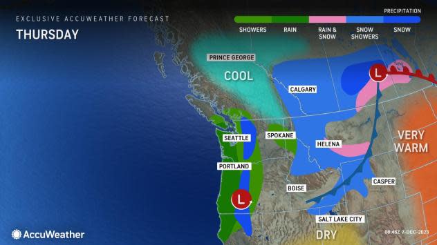
"From Wednesday night to Thursday, the [atmospheric] river will break down into a more typical pattern with rounds of rain as it shifts southward into southern Oregon and Northern California," AccuWeather Meteorologist Joseph Bauer said.
 |
The heaviest and steadiest rain will stay to the north of San Francisco, but the City by the Bay will get some showers for a time into Thursday.
"It appears that the air will remain warm enough for just rain to fall on the high ground along Interstate 5 in southern Oregon and Northern California into Thursday," AccuWeather Senior Meteorologist Heather Zehr said, adding, "However, it will turn cold enough fast enough for rain to change to snow, a freeze-up and bring slippery conditions to Donner Pass, California, along I-80 from late Wednesday night to Thursday night."
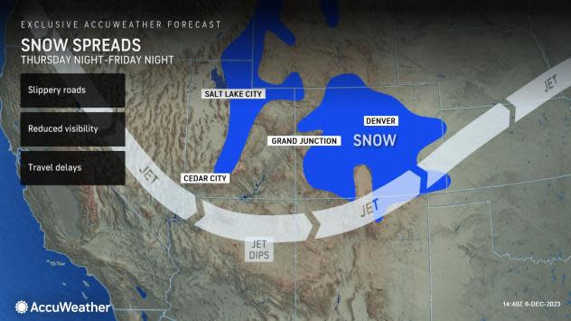
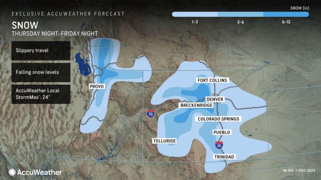
As the jet stream dips and pushes inland, it will create more of a storm across the interior West from Thursday to Friday, where it will become cold enough for mostly snow to fall from parts of southern Idaho and northern Nevada to portions of Utah, Wyoming, Colorado and northern New Mexico.
 |
Building warmth over the Rockies into Thursday will depart as the storm gets underway by the end of the week.
Salt Lake City will experience rain showers into Thursday. However, as the storm forms and creates colder air, periods of snow are likely from late Thursday night to Friday, with a slushy coating to an inch or two possible.
In the higher elevations of the Wasatch Range and the central Rockies, snow will ramp up from Friday to Friday night with several inches or more likely that should have skiers jumping for joy.
 |
Motorists and airline passengers around Denver may experience delays due to slippery roads and deicing operations as temperatures crash from near 40 degrees Fahrenheit at midday through the 30s and 20s Friday night.
The system over the interior West will evolve into a major storm with severe weather, heavy rain, a band of heavy snow and severe thunderstorms as it swings out over the Central states this weekend.
Want next-level safety, ad-free? Unlock advanced, hyperlocal severe weather alerts when you subscribe to Premium+ on the AccuWeather app. AccuWeather Alerts™ are prompted by our expert meteorologists who monitor and analyze dangerous weather risks 24/7 to keep you and your family safer.
