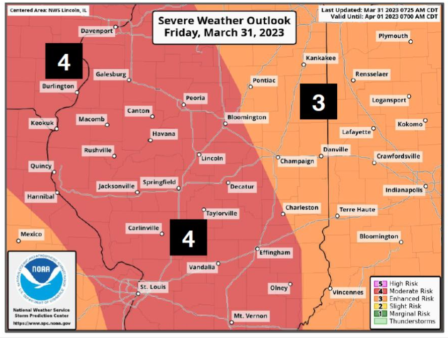
'High risk' of severe weather and possible tornadoes in the Peoria area
PEORIA – The National Weather Service has put out an ominous warning about the severe weather due to hit central Illinois this afternoon:
"Parts of IL including Peoria and Galesburg will be upgraded to a HIGH risk of severe weather for this afternoon/evening. Long track violent tornados possible. Last high risk in central IL was 11/17/2013 (Washington's EF4 tornado) Take this situation VERY seriously!"
Parts of IL including #Peoria and Galesburg will be upgraded to a HIGH risk of severe weather for this afternoon/evening. Long track violent tornadoes possible. Last high risk in central IL was 11/17/2013 (Washington's EF4 tornado). Take this situation VERY seriously! #ILwx pic.twitter.com/SCkWgfY5b4
— NWS Lincoln IL (@NWSLincolnIL) March 31, 2023
The area of enhanced risk goes as far north as Cedar Rapids, Iowa, west to Ottumwa, Iowa, south to Quincy, and east to Peoria and Pekin.
Storms are predicted to arrive in Peoria around 2 p.m. and continue to around 7 p.m. this evening said Matt Barnes, a meteorologist with the National Weather Service in Lincoln. Severe weather will arrive in two waves.
"Right now we are watching some activity in northern Missouri. We've got a scattering of strong and severe storms that will be moving through during the early to mid-afternoon," said Barnes. "Then there is going to be line that forms a little bit further west — right now it's beginning to take shape in eastern Kansas, and that will come through in the early evening hours, maybe 6 o'clock or so."
The National Weather Service is keeping a close eye on the situation because the storms will move very quickly — probably about 60 miles per hour, said Barnes. Additionally, these storms will be capable of producing long-track tornadoes, the type of tornado that hit Washington in November 2013.
"These are storms that will be capable — not that they necessarily will produce a tornado — but if they do they could be pretty long lived," said Barnes. "Sometimes we have storms around here that come through and we have a brief tornado touchdown with the storm — that is not this type of storm. We are looking at the type of storm that could produce a long-lived tornado that could do considerable damage. So we are giving people a heads-up — this is a little more elevated threat than we see on an average severe storm."
The most important thing for people to do is to be aware of the changing situation, said Barnes.
"Whatever method you get your severe storm tornado warnings, whether it be TV, whether you've got a weather radio at home, or an app on your phone, I would be keeping my eyes peeled. And if a warning is issued, you need to take action right away," said Barnes.
A tornado watch was issued for the area around noon, and already residents in central Illinois have begun to prepare. Schools in East Peoria, Morton and Washington dismissed early to get kids home before the storms come into the area.
A previous version of this story is below:
The spring storm season will start with a bang on Friday.
A strong low-pressure system heading into central Illinois Friday afternoon could produce high winds, hail and tornadoes, said John Bumgardner, a meteorologist with the National Weather Service in Lincoln.
“All the ingredients are coming together for severe thunderstorms,” he said. “There’s a chance we could have some marginally severe hail tonight, but the better threat is going to be tomorrow afternoon and evening where storms form either along or just ahead of a cold front. These storms will be rotating, so they will have the potential to produce a couple tornadoes, but the bigger threat will be hail and especially damaging straight-line winds, possibly over 70 miles per hour.”
After a few thunderstorms tonight, the Peoria area will likely see warm, sunny weather during the day Friday. Temperatures could even reach 70 degrees, but those warm temperatures may come at a cost, said Bumgardner.
“It’s looking increasingly plausible, if not likely, that we’ll get some breaks in the cloud cover, which will allow the sun to heat up the ground, and the lower atmosphere will become pretty unstable,” he said. “What that means is we’re going to have lots of energy for thunderstorms.”
Peoria at risk for severe storms
The storms are likely to be most severe in Iowa, said Bumgardner, but Peoria is in the line of fire as the storm moves east.
“You guys in Peoria are in a more favored location for severe weather,” he said.
More: Dangerous strep throat cases on the rise in the Peoria area. Here's what you need to know
Though the entire state of Illinois is at risk, northern Illinois, starting around Peoria, has a greater potential for severe storms.
“Basically, between Peoria, Chicago and Cedar Rapids, Iowa, if you made a triangle there, that’s probably the area of greatest concern,” he said.
Forecasters say the storms will start firing up in Iowa around 4 p.m. and taper off around 8 p.m.
“Looks like things are going to sweep through pretty fast,” said Bumgardner.
Prepare for strong winds
To prepare for the possibility of severe weather, people should secure outdoor objects that could become airborne in high winds.
“Trampolines can become Frisbees. Items like that could blow around and cause damage. It’s a good idea to secure those or move them indoors,” said Bumgardner. “Also, if we go under a severe thunderstorm warning, because these winds can be so strong, if you have big trees near your house you don’t want to be in the upper level of your home or be near a window. And if we go under a tornado warning, go to the lowest level of your house. If you don’t have a cellar, put as many walls between yourself and the outdoors as you can.”
More: A new retailer plans to open in the former Gordmans building in Peoria. Here's what we know
As strong weather approaches, it’s important to stay alert and pay attention to the warnings.
“We also encourage people to have multiple ways to receive warnings, weather that is NOAA weather radio or a cellphone app, radio or television,” said Bumgardner.
After the severe weather passes, temperatures will drop from 70 degrees on Friday into the 40s on Saturday. Strong winds, with gusts up to 45 miles per hour, will continue until about 9 or 10 a.m. Saturday, said Bumgardner.
“For most of the night after about midnight we’ll have nearly continuous wind gusts of 40 to 50 miles per hour, perhaps 55 miles per hour."
Leslie Renken can be reached at (309) 370-5087 or lrenken@pjstar.com. Follow her on Facebook.com/leslie.renken.
This article originally appeared on Journal Star: Hail, high winds and tornadoes in the forecast for Peoria on Friday

