Flood watch issued as half foot of rain, or more, may swamp Midlands from Hurricane Idalia
A flood watch was issued Tuesday afternoon for the Columbia area in preparation for Hurricane Idalia. The watch goes into effect Wednesday afternoon and will run through Thursday afternoon, according to the National Weather Service.
Additionally, a Tropical Storm Watch is in effect for parts of the Midlands — including eastern Orangeburg County as well as Clarendon and Bamberg counties, the National Weather Service said.
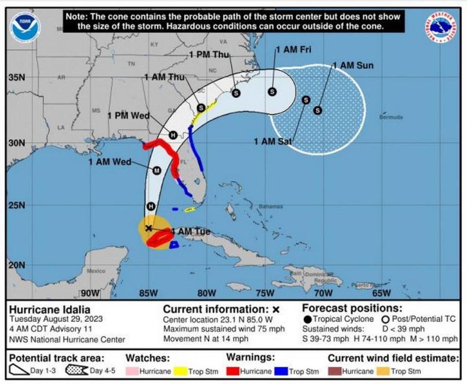
Hurricane Idalia is building strength as it churns in the Gulf of Mexico, but is expected to be a tropical storm — or even a tropical depression — when it reaches South Carolina, the National Weather Service said Tuesday morning.
But even a downgraded storm is still expected to dump large amounts of rain on the Columbia area, National Weather Service Meteorologist Matt Gropp told The State. Idalia will also bring the threat of powerful wind gusts and possible tornadoes to the Midlands, Gropp said.
The center of Idalia is expected to move over the South Carolina coast on Wednesday and Thursday, according to Gropp. While increased winds can begin by Wednesday morning, the bulk effects of the storm are forecast to impact the Columbia area between 3 p.m. and 6 a.m. Thursday, Gropp said.
Between 3 to 6 inches of rain is forecast to swamp the Columbia area during those peak hours, according to Gropp.
Localized rainfall amounts could be higher, and reach 8 inches, Gropp said.
“It won’t be a hurricane in the Midlands, but it could still be a tropical storm, and the impacts will still be significant,” Gropp said. “That’s just a lot of rain.”
With all of that rain, along with significant amounts of precipitation recorded Sunday and Monday, as well as a 50% chance of more showers and thunderstorms Tuesday, flooding is a serious threat, according to the National Weather Service.
Heavy rain and possible floods will pose threats to drivers, especially those on the road during rush hour on Wednesday evening and those making the Thursday morning commute, when visibility might be limited, according to Gropp.
“We advise them to not be on the roads, if they can, when the rain is like that,” Gropp said.
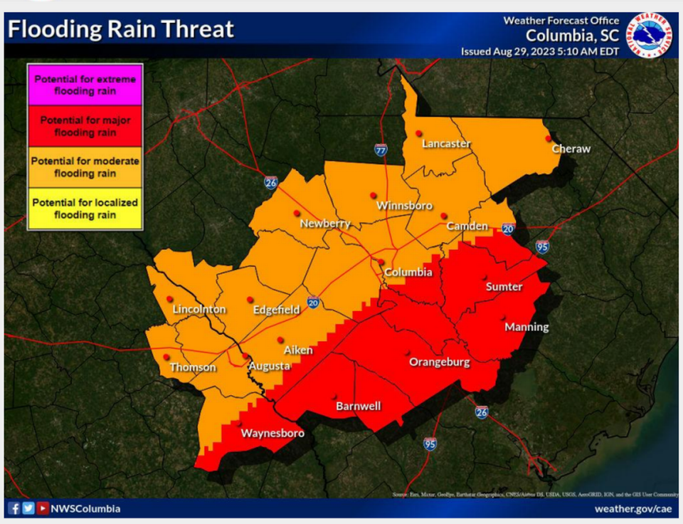
Potential flash flooding is the greatest threat during the storm, but as Idalia dumps more rain on the Columbia area, river flooding becomes another possible hazard, the National Weather Service said.
“We’re expecting river flooding to be an issue even after Idalia moves out of the area,” Gropp said. “The rivers are already swelling.”
River flooding remains a threat Thursday and through the weekend, according to the National Weather Service.
The latest forecast has the center of Idalia moving over the South Carolina coast, but it shifted slightly to the west and more inland, the National Weather Service said. Further deviation to that track — to the east or west — is possible, according to the National Weather Service.
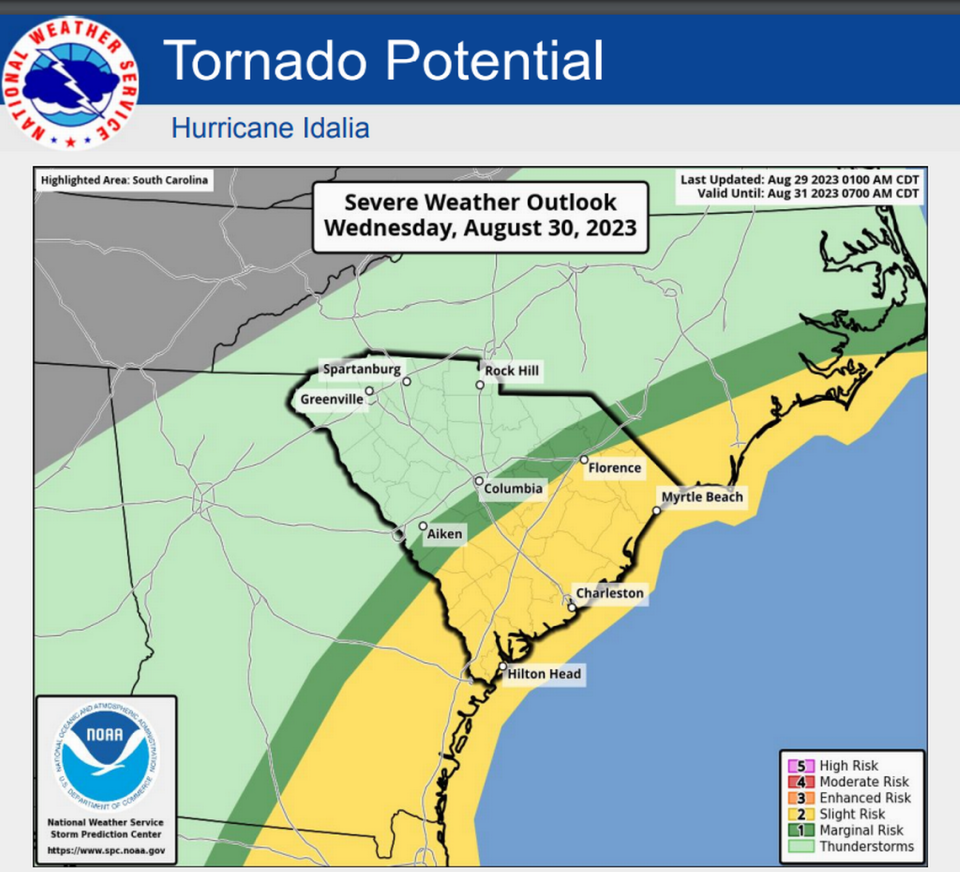
One affect of the shift in track is a greater chance of tornadoes forming in the Midlands, the National Weather Service said. The area at greatest risk of experiencing a tornado is in the eastern portion of the Midlands, in Orangeburg, Clarendon and Calhoun counties, according to Gropp.
The National Weather Service warned not to focus on the exact track, since Idalia’s impacts can happen well outside the area enclosed by the storm’s cone.
While Idalia’s winds were considered life-threatening before making landfall in the southeastern U.S. Tuesday, Gropp said the strength is predicted to “drop off dramatically,” when it is affecting the Columbia area.
Should Idalia be at tropical storm levels when it hits South Carolina, it will move through with winds as high as 39 mph, according to the National Weather Service.
The combination of powerful wind gusts and rain-soaked soil could cause trees to be uprooted, Gropp said.
Powerful winds and tornadoes could cause considerable damage to trees and branches, in addition to mobile homes, roofs and outbuildings. Vehicles would also be under siege in the case of a tornado.
Damage to trees and branches creates the possibility of downed power lines and outages.
The forecast calls for temperatures to drop to around 80 degrees on Wednesday, Thursday and Friday.
Idalia would be the first hurricane or tropical storm to affect the Columbia area in 2023, according to LaVoie. Last year, the remnants of Hurricane Ian and Tropical Storm Nicole doused the Midlands in October and November, respectively.
As of 11 a.m. Tuesday, the storm was moving north at 14 mph toward Florida, and had maximum sustained winds of 85 mph, according to the National Hurricane Center.

