Hawaii weather: What is a Kona low?
People who have lived on or spent a considerable amount of time in Hawaii may have heard the term Kona low and have some basic knowledge that it brings unsettled weather of some sort to the islands.
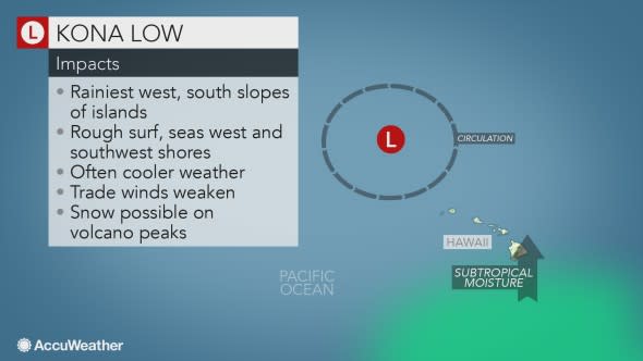
Northeast trade winds tend to dominate the weather on Hawaii. Northeasterly breezes create wet conditions on the northern and eastern sides of the islands as moisture is squeezed out over the mountains. These areas have exponentially much more rain than locations on the southern and western sides.
The term "Kona" translates to the western or southwestern side of an island in the native Hawaiian language.
The term "low" translates to a storm, which creates rising air and corresponding low atmospheric pressure. Rising air causes clouds to form and, if significant enough, can bring precipitation and strong winds.
While most of the weather produced by a Kona low is near the surface, the storm is usually most prevalent at the jet stream level of the atmosphere. As a Kona low forms, a southward dip in the jet stream evolves then breaks off from the main jet stream and forms a circular jet stream pattern.
"Kona lows are most common during the late fall, winter and spring and are associated with a southward plunge of cold air over the central Pacific Ocean," according to AccuWeather Meteorologist Maggie Samuhel.
Without access to a weather map, the presence of a Kona low can be revealed by an extensive area of bubbly clouds over the Pacific Ocean.
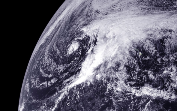
This satellite image shows a mature Kona low over the central Pacific Ocean on Dec. 19, 2010. (NOAA / Satellite)
"These storms typically approach Hawaii from the northwest and then push cooler or colder air across the islands," Samuhel said. "Kona lows often tend to bring cloudy and wet conditions to the western and southwestern sides of the islands, or opposite of that of the prevailing trade winds."
Honolulu may receive significant rain when a Kona low is approaching.
Sometimes developing Kona lows can tap into subtropical moisture and unload flooding rainfall.
"West to southwest winds associated with a Kona low can also cause significant waves beyond the protection of the reefs," according to AccuWeather Senior Meteorologist Dan Kottlowski.
"Higher-than-normal water levels and coastal flooding can occur along the western and southwestern shores of the islands in the more extreme cases, especially when a corresponding storm develops in the lower part of the atmosphere," Kottlowski said.
"When a surface storm and the Kona low coincide is the most likely time for coastal flooding as well as flash flooding from heavy rainfall in Honolulu and other areas on the southern and western sides of the islands," Kottlowski added.
The colder air associated with Kona lows can often produce snow and sometimes even blizzard conditions over the peaks of the volcanoes.
Kona lows can often play a role in the movement of tropical storms that approach the islands from the south or the east during the summer and early autumn.
"If a Kona low is nearby, the position and counterclockwise circulation around the storm may cause a tropical storm to get very close to or be forced to turn away from the islands," Samuhel said.
On rare occasions, a Kona low can evolve into a subtropical and tropical storm.

