Hazardous roads greatest threat posed by winter storm closing in on the Midlands
For the second time in a week, a severe winter storm is bearing down on the Columbia area.
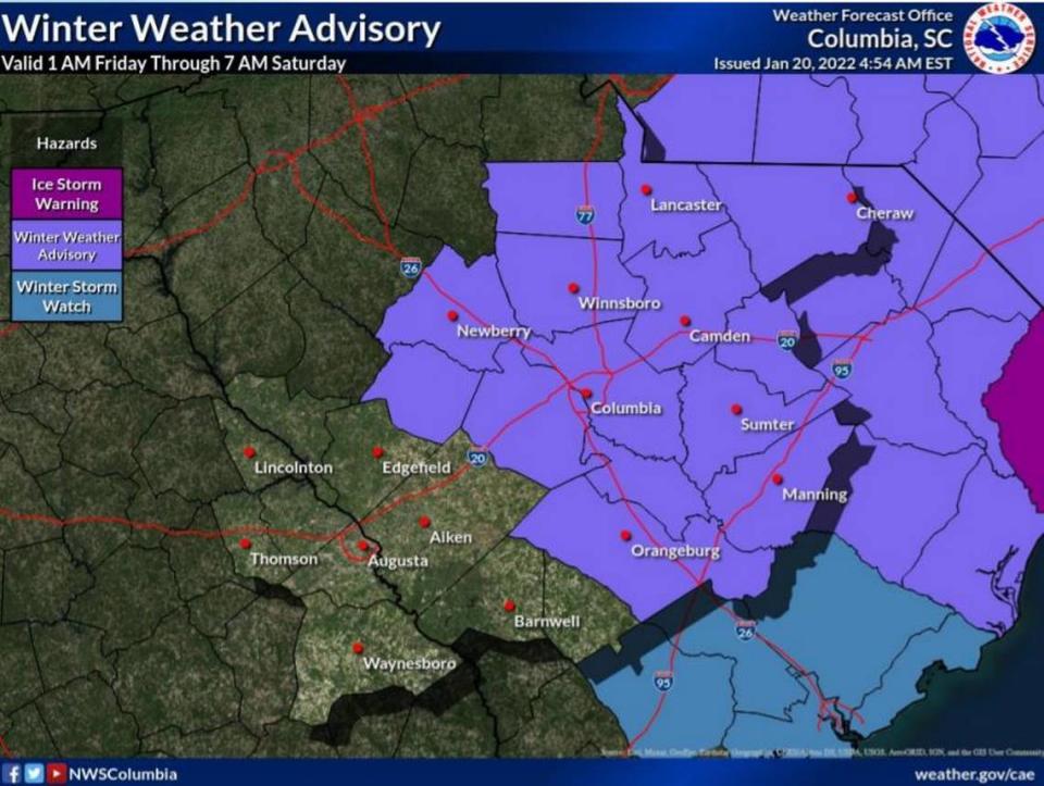
As was the case last Sunday, freezing rain, snow and sleet are in the forecast. That prompted the National Weather Service to issue a winter weather advisory Thursday. It is in effect until 7 a.m. Saturday.
Rain has already begun, and an on-and-off drizzle is expected throughout Thursday. But overnight, at about 3 a.m., that precipitation is expected to become a wintry mix, National Weather Service meteorologist Nicole Steeves told The State.
As the temperatures continue to fall, that precipitation will primarily be freezing rain, according to Steeves.
This is going to create dangerous driving conditions for anyone on the roads Friday, especially during the morning commute.
“The travel conditions may be hazardous on bridges, overpasses, and untreated roads,” Steeves said. “Plan on slippery road conditions.”
Unlike the last storm, which dissipated as the temperature rose, it’s not going to get much warmer during the day on Friday. With a possible high of 33 degrees, wet and icy roads will still be a hazard during the evening commute and through the night, according to Steeves.
There will also be a second round of precipitation on Friday night that could complicate conditions, Steeves said.
“Stay off the roads unless absolutely necessary once the storm begins,” South Carolina Gov. Henry McMaster said in a news release after declaring a state of emergency on Wednesday. “South Carolina is expected to experience winter storm weather again this week. Those in potentially impacted areas should begin safety preparations now. Please check your local forecasts.”
Travel might be treacherous, the South Carolina Emergency Management Division said. The agency urged anyone behind the wheel to drive slowly, watch for black ice and down trees, and follow any warnings to stay off the roads.
Unless travel is absolutely necessary, avoiding driving was a request made by multiple agencies, as well as government and law enforcement officials.
Most Midlands school districts have switched from in-person classes to virtual lessons online on Friday because of the potential for widespread hazardous travel conditions caused by freezing rain.
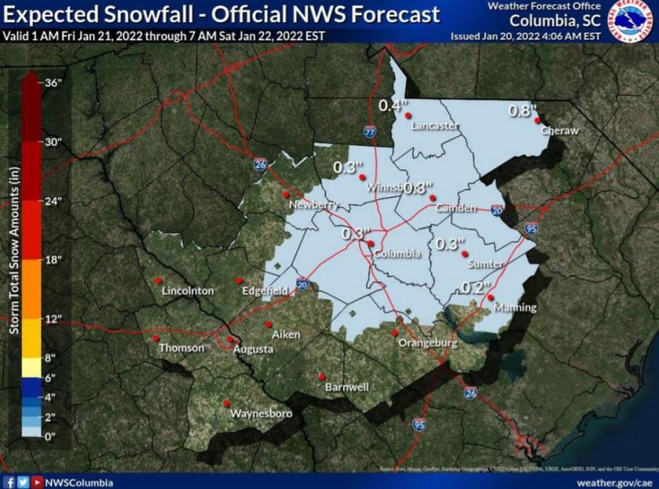
Less precipitation is expected in this storm compared to the one that swamped the Midlands last weekend.
Anywhere from a trace amount to a tenth of an inch of ice is expected to accumulate, Steeves said. Areas in Clarendon and Lee counties might experience more ice build up, according to Steeves.
While there might be more visible snowfall in the Columbia area on Friday, very little of the white stuff will stick, Steeves said. As with the ice forecast, more snow accumulation is possible in northern portions of the Midlands, according to Steeves.
The last measurable snowfall at Columbia Metropolitan Airport was on Jan. 6, 2017, when about a tenth of an inch was recorded, the National Weather Service said.
There will be less wind as well, as Steeves described the expected conditions as breezy, not gusty.
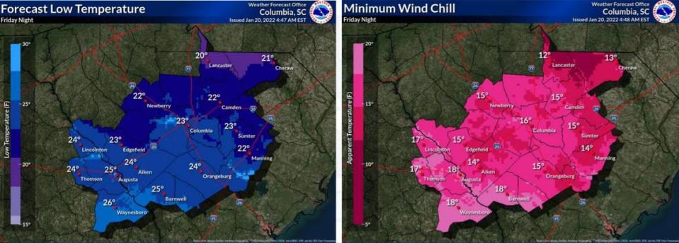
But the wind chill will be much more of a threat in this winter weather event. Wind chills are forecast to drop into the low-to-mid teens, and prolonged exposure to the elements might lead to frostbite and hypothermia, according to the National Weather Service.
Even after the storm is predicted to taper off by Saturday morning, the cold temperatures are sticking around the Midlands. The potential high on Saturday is 40 degrees, and it won’t get much warmer on Sunday, the forecast shows.
Through the weekend, lows will be in the 20s, and that’s without factoring in effects of the wind chill.
“We want to remind folks it will be very cold after the storm,” Steeves said. “Bring in plants and pets, and be prepared for cold temperatures.”
Black ice will be a threat late Friday night through Saturday and into Sunday morning, as there could be freezing, followed by warmer temperatures, and more freezing, the National Weather Service said.
Black ice is difficult to see and makes roads very slippery, especially bridges and overpasses. Black ice forms when snow or light rain falls on frozen concrete or asphalt, freezing quickly to form a layer of ice that is almost invisible against the backdrop of blacktop roads.
Because there isn’t expected to be as much precipitation in this storm, there might not be as much ice and snow accumulating on elevated surfaces like trees and branches.
That factor, along with a reduced wind threat, means that power outages might not be as widespread as they were last weekend, when more than 100,000 outages were reported by customers in South Carolina — with nearly half in the Midlands.
Downed trees, branches and power lines will be more isolated in the coming days, according to Steeves. But there is still the threat of branches falling and causing a blackout.
Winter weather supplies kit
Flashlights and extra batteries
Extra chargers for your cell phones and mobile devices to keep them at a full charge
Battery-powered NOAA weather radio
Extra food and water, such as non-perishable/high-energy foods and snacks
Extra medication
Extra baby items if you have infants or small children
Basic first-aid supplies
Blankets, sleeping bags and extra clothing for warmth
Gather and store extra firewood in a dry sheltered area
Pet food and items to keep your animals protected from winter conditions
Source: South Carolina Emergency Management Division

