Headed outside this holiday season? Here’s your guide to SLO County’s best hiking trails
During the busy, bustling holiday season, you might be tempted to take a break and step outside.
Fortunately, San Luis Obispo County has a plethora of incredible hiking trails with stunning views, unique plants and fantastic wildlife.
The Tribune has assembled a guide to some of the best hikes in the county to help you enjoy the fresh air and beautiful scenery.
The distances listed below are based on those listed on the trail guide app AllTrails.
San Luis Obispo
Few hikes in the San Luis Obispo area are more iconic than those at Bishop Peak and Cerro San Luis.
The two volcanic Morros stretch high into the sky.
At the top, you’ll find panoramic views of the city and even get a peek at the ocean. You’ll also see plenty of oak trees and may encounter birds, squirrels, deer, horses and cattle.
To explore Bishop Peak, start from the Highland Drive trailhead for a 4.2-mile hike, or take the Patricia Drive trailhead for a hike of about 3.5 miles.
There’s also the 2.4-mile Felsman loop, which takes you around the base of the peak. You’ll get great views of the city while enjoying the feeling of being in a remote natural ecosystem.
You can hike up to the top of Cerro San Luis, also known as Madonna Mountain, on a 4.9-mile loop starting at Laguna Lake Park.
There’s also the 3.9-mile out-and-back trail through the Maino Open Space starting at a trailhead off the intersection of Highway 101 and Marsh Street.

Looking for more SLO hikes?
Try the Reservoir Canyon loop trail, which embarks from Reservoir Canyon Road off Highway 101.
This 5.4-mile loop will take you along a creek and up to the top of High School Hill, serving you incredible views of the canyon, the city and the ocean.
The Froom Canyon trail in Irish Hills Natural Preserve is another favorite. A jaunt along this 4.1-mile loop behind Costco will take you from the city deep into nature.

Pismo Beach and South County
Visitor and locals alike can enjoy the beautiful trails around Pismo Beach.
The easygoing Meadow Creek Trail, just 1.5 miles long, takes you from the Pismo Beach Monarch Butterfly Grove, where you can see thousands of the fluttering insects during the wintertime, to Pismo State Beach.
The Pismo Preserve is to go-to spot for superb hiking trails in the area.
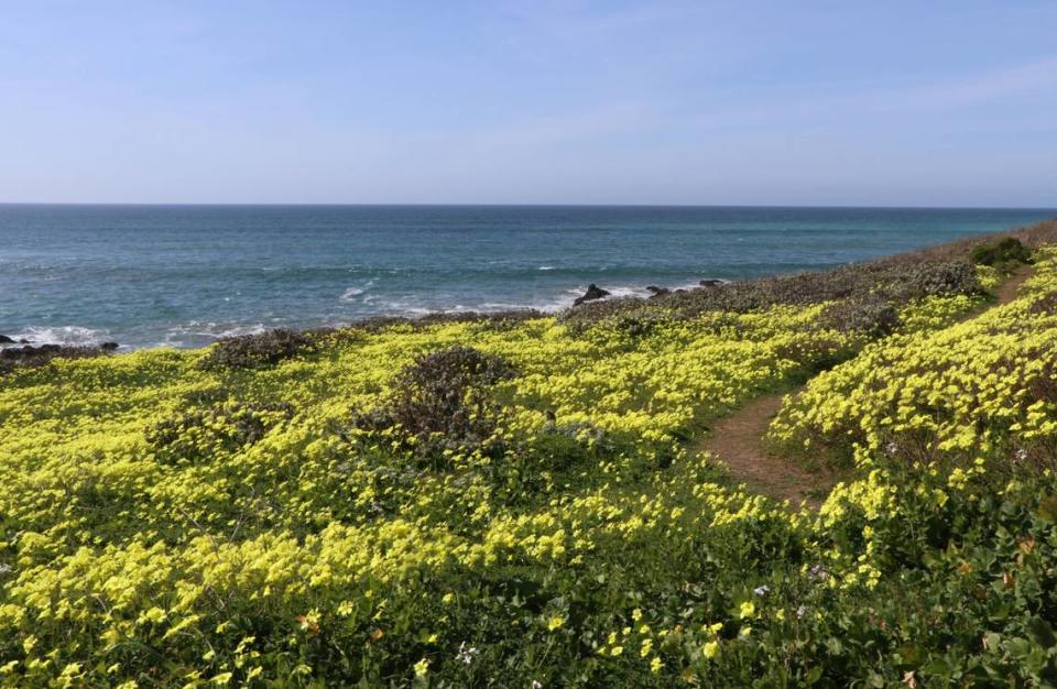
One option is the classic Discovery Trail. This 5.4-mile loop features some of the best views of the Pacific Ocean along the Central Coast, as well as great wildlife viewing options.
For more of a challenge, try the Ontario Ridge trail via Shell Beach Road. This 2.2-mile out-and-back trail is a tough one, with a steep, sometimes slippery gravel start.
You’ll be rewarded with ocean views as you emerge from under huge oak trees.
One of the most easy-going hikes in southern San Luis Obispo County is the Osos Flaco Lake trail, which is 2.2 miles roundtrip and nearly all on a wooden boardwalk. Bird watching opportunities abound.
You can continue your journey south to the Guadalupe-Nipomo Dunes or north to the Oceano Dunes.
The 1.7-mile James Way trail in Arroyo Grande is another great option for a short family hike. You’ll be greeted by towering oak trees and may see some wildlife along your journey.
Much farther east is the unbeatable Carrizo Plain National Monument.
You’ll truly feel like you’re in the middle of nowhere surrounded by the stunning Caliente Mountains. Take the 1.3-mile Soda Lake overlook for views of the unique alkaline lake.
Morro Bay and Los Osos
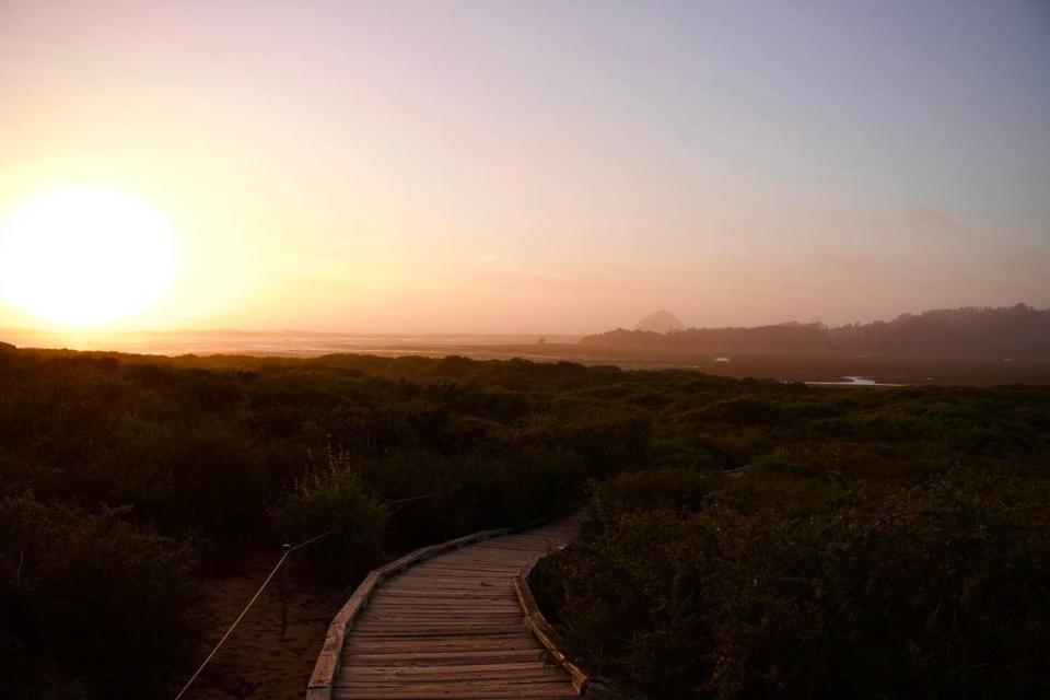
If you’re looking for a quick jaunt to stretch your legs, the Elfin Forest Natural Area boardwalks might just right for you. The boardwalks are about a mile long and feature great bird watching spots with views of the Morro Bay estuary.
Up for a bit of a bigger hike?
Just up the road from the Marina Point hike is Black Hill. There are several starting points to get to the top of this beautiful vista point.
One good option is to start near the Morro Bay State Park campground and take the 4.1-mile out-and-back trail to the top.
You can also drive up to Upper State Park Road and park at the small trailhead for the short, half-mile hike to the top.
There are also quite a few trails up and around the base of Cerro Cabrillo, another volcanic plug in the county.
A great starting point is the quarry trailhead off South Bay Boulevard.
From there, it’ll be a 2.4-mile out-and-back trail to the top of Cerro Cabrillo, or you can hike around any of the number of trails in Morro Bay State Marine Reserve.
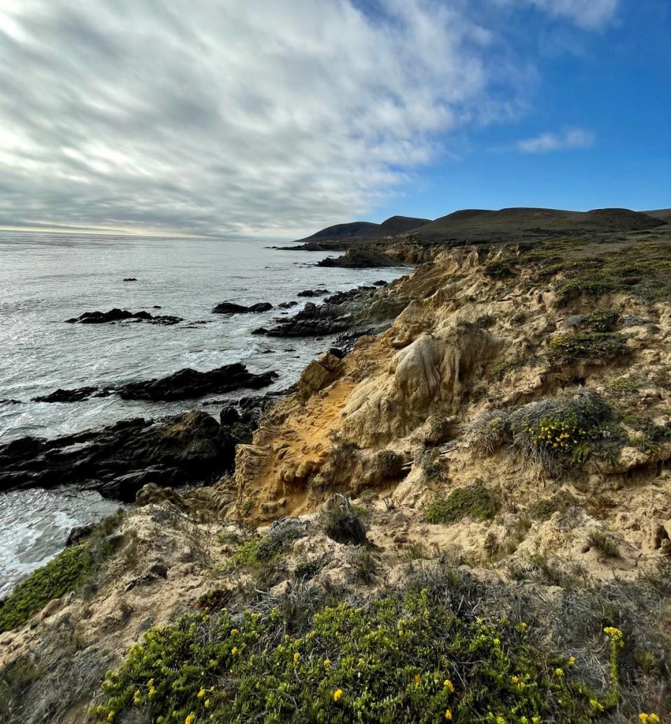
Los Osos marks the entrance to Montana de Oro State Park. This is arguably one of the best places to hike in the county with countless options for trails offering incredible views of the ocean cliffs.
An easy option in the park is the classic Bluff trail, which is about 4 miles roundtrip. Here, you can peek over the edges of the bluffs into the roaring Pacific Ocean below. You may even spot sea otters or seals diving for food.
For more of a challenge, take the 4.5-mile out-and-back trail up to Valencia Peak. Up a steady trail, you’ll constantly have incredible views of the ocean and be rewarded with a nice picnic spot at the top.
Another good option in the park is the Rattlesnake Flats trail via the Coon Creek trail.
Here, you’ll find a pleasant walk along a valley beside a trickling creek before the trail takes you halfway up the ridgeline for an incredible vista of the ocean.
Along the Coon Creek trail, you also have the option to continue hiking to Oats Peak, which is about seven miles out and back.
Cayucos
Whether you’re a local or a tourist driving up Highway 1, there are great trails in the Cayucos area.
Estero Bluffs State Park right off the highway features the 7-mile out-and-back Estero Bluffs trail with constant views of the ocean crashing along the rocky shoreline.
Cayucos Point is a popular stopping point about halfway in. From there you can see coastal birds feeding off the ocean and perhaps even glimpse whales in the ocean.
Closer to town, you can hike by the Whale Rock Reservoir. A 4.1-mile out-and-back trail begins off Old Creek Road and travels alongside the important water source in the county.
No swimming is allowed in this reservoir.
Further up Highway 1 is Harmony Headlands State Park, just off Highway 1 past Estero Bluffs.
Take the 4.3-mile out-and-back Headlands trail for a walk through stunning meadows, past coastal mountains and be greeted at the end with incredible views of the bluffs and Pacific Ocean.
Cambria
Though a small town, Cambria boasts dozens of hiking trails for beginners and experts alike.
In this area, you’ll hike under towering Monterey pine trees and oak trees and through meadows that brim with wildflowers in the springtime.
A classic option is the Moonstone Beach trail. The 2-mile out-and-back trail takes you on a boardwalk along the coast. You can start at the mouth of the Santa Rosa Creek, or in several spots along Moonstone Beach Drive.
A centerpoint is Fiscalini Ranch Preserve, which visitors can find a great network of trails that venture through the trees and into the open meadows along the coast. You may even spot some overwintering monarch butterflies, or spot whales breaching as sea birds dive for food.
Drive along Highway 1 farther north and you’ll find Hearst San Simeon State Park. The 3.3-mile San Simeon Trail to Washburn Campground loop offers wildlife with occasional coastal views.
Paso Robles
Want to take a break from wine tasting? Paso Robles offers plenty of options for lovers of the great outdoors.
The 3.9-mile out-and-back Salinas River walk will take you along the mostly-dry Salinas riverbed. Much of this trail is on a boardwalk or paved trail and you’ll see oak trees and dense brush in this natural escape from the city.
Another option is the 2.1-mile out-and-back Montebello Oaks Open Space trail. You’ll go from hiking under massive oak trees to open meadows with wildflowers in the springtime.
Venturing farther up north to the edge of the county you’ll find Lake Nacimiento. Hike along the 4.8-mile Shoreline trail for views of the lake and potential wildlife sightings.

Atascadero
At 1.3 miles long, the Atascadero Lake Park trail loop around the lake won’t take you long. You’ll find plenty of picnic spots under lots of trees with ducks waddling past.
For something a bit more challenging, head to Stadium Park to hike up Pine Mountain. The 1.7-mile Pine Mountain Loop will take you to the top for views of the city and surrounding mountains and a unique metal monolith at the top.
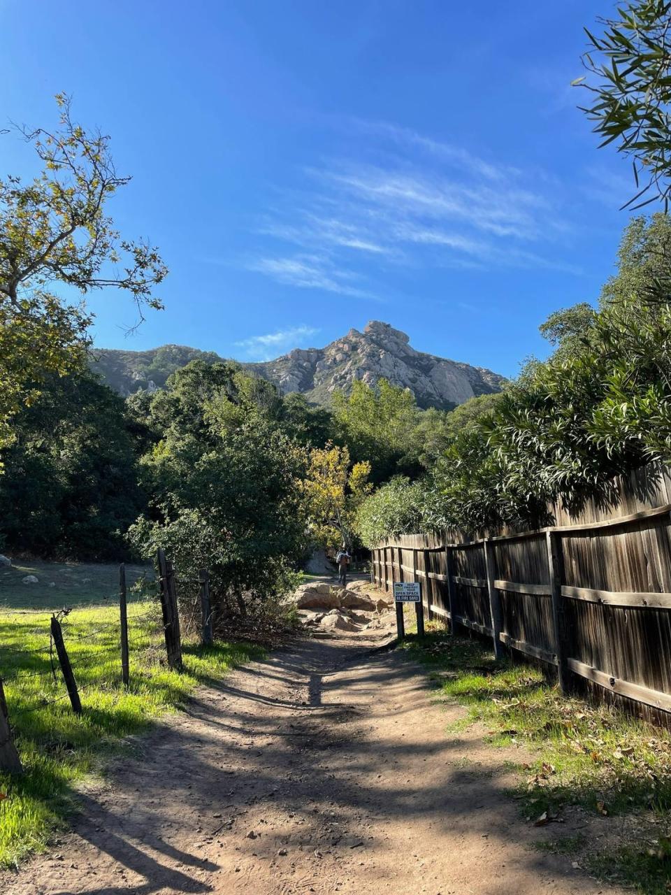
Head west on Highway 41 and into Los Padres National Forest to hike around Cerro Alto, which offers views of Morro Rock on clear days.
The 8.6-mile Boyscout trail to the top of Cerro Alto will take you through the densely wooded valley and up to the rocky summit.
Fair warning: You’ll need to pay $10 to park at the trailhead. This cost helps fund the maintenance of the trail and others within the national forest.

Safety tips for hikers
Heading out on the trail? Here are a few handy safety tips.
The weather in San Luis Obispo County can change quickly. You might want to carry a hat, sunscreen and extra socks in your backpack while hiking, as well as extra layers such as a jacket, long-sleeve shirt or long pants.
Do research before heading out on a new trail.
Online trail guides such as AllTrails or Gaia GPS are great for looking up trail reports, maps and pictures. These online platforms have options to download the information to your phone before you embark on your journey.
Tell a friend where you’re headed and how long you expect to be gone before leaving.
Even experienced hikers can come upon unexpected trouble while hiking. A basic first aid kit can be great for mending small cuts icing a rolled ankle, or treating burns and stings.
Bringing plenty of water is essential. You might also want to pack a few snacks, including granola bars, fruit snacks, nuts and other small food items.
It’s also important to be courteous, so don’t leave your trash on the trail and avoid hiking with headphones or music speakers.
If you see wildlife on the trails, do not disturb it or try to approach.
Several people have seen mountain lions while on hikes in San Luis Obispo County. If you spot one, make a lot of noise and try to look as big as possible by waving your arms around or gathering your hiking group close together.
Doug Carscaden, San Luis Obispo city’s ranger service supervisor, put it this way: “Be respectful of others, be respectful of the land, be respectful of wildlife and have a great time.”

