Heat dome holds strong over southern US after retreating from Midwest


Last week featured some of the hottest weather of the entire year across part of the north-central United States, but AccuWeather meteorologists say that relief is on the way for some, but not all, of the region through Monday, and temperatures in the Southeast will continue to throttle up.
Wednesday was one of the most extensive days of blistering, humid conditions during the entire heat wave over the Central states. In Chicago, the mercury ascended to 98 degrees Fahrenheit on Wednesday. However, the very next day the atmosphere topped that mark with a high of 100 F. The last time that there were triple-digit highs in the city was on July 6, 2012, according to the National Weather Service.
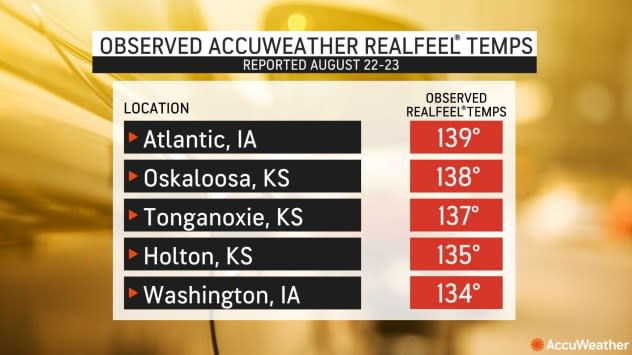
Maximum AccuWeather RealFeel® Temperatures soared to the 130s in a handful of states, with Atlantic, Iowa, topping out at 139 degrees, the top of the scale, described as "Extraordinarily Dangerous."
 |
AccuWeather RealFeel(R) Sun Temperatures on Tuesday and Wednesday, degrees F, were in the upper 130s in several states. |
Changes soon took place to knock down the heat in part of the central region, however.
As a cool front advanced southward and a disturbance high in the atmosphere dove across the Great Lakes and into the Northeast, relief from the exceptional heat that has gripped portions of the central Plains and Midwest will continue, AccuWeather Meteorologist La Troy Thornton said.
The Dallas/Fort Worth area has endured 47 days this summer through Sunday with highs of 100 F or greater, including blistering highs of 110 on Friday and Saturday that established new daily records while also marking the hottest days of the summer so far. Meanwhile, Bergstrom Airport in Austin, Texas, has hit the century mark 53 times.
Historical average daytime highs at both locations are extreme -- in the mid- to upper 90s during much of the summer. However, temperatures in these areas were still 3-5 degrees above the average mark since June 1.
Farther to the east this summer, some of the biggest temperature departures have occurred in Louisiana and Mississippi.
In New Orleans, the temperature crested at 102 degrees on Wednesday, which tied the all-time high for the city set on Aug. 22, 1980. Temperatures hit 100 on Thursday and Friday after another high of 102 on Saturday. Then, on Sunday New Orleans broke their all-time temperature record, reaching 105 for the first time in recorded history. The heat is expected to subside some today, falling into the mid-90s on Monday.
In Jackson, Mississippi, temperatures trended higher as the summer progressed from June to August. For the month of August so far, temperatures have averaged more than 6 degrees above the historical average with at least 20 days with highs of 100 or greater. A high in the low 90s is typical.
 |
The summer has been no picnic in terms of comfort for much of the Southeast states as well. Very high humidity, even by southern standards, has literally been a "sticky point," consistently pushing AccuWeather RealFeel® Temperatures to dangerous levels above 100 on many days from Florida and Georgia to the Carolinas and Alabama.
In the Southeast states, the greatest temperature departures from historical averages have been near the Gulf coast and the Florida Peninsula. Even long-term residents of Florida have noticed the hotter conditions, where temperatures have been 2-3 degrees above the historical average since June 1 and 3-4 degrees above average for August. Typical highs in much of Florida are in the low to mid-90s in the summer.
As aforementioned, another surge of heat is coming for some of the last unofficial days of summer for the Southeast.
"As the 'round-shaped' heat dome gets 'flattened,' extreme temperatures will be pushed into the Southeast states, where cities such as Atlanta could record the first triple-digit high temperature of the summer," Thornton said. The highest temperature so far this summer in Atlanta was 99, which occurred on Saturday. The last time that the temperature in Atlanta reached 100 degrees was Aug. 13, 2019.
Mobile, Alabama, which never surpassed 100 degrees in June or July and has struggled to break 101 degrees so far in August, reached a high of 106 on Saturday setting a preliminarily new all-time high for that city.
 |
People spending time at area theme parks in central Florida are strongly encouraged to stay hydrated in the dangerously hot and humid conditions.
Metro areas such as Oklahoma City, where high temperatures had remained at or above 100 since Aug. 19 before a high of 99 on Saturday, ended up with temperatures falling near the historical average on Sunday. During late August, a high near 90 is typical for them, and Oklahoma City reached a high of only 91.
In terms of rainfall, periodic downpours have been responsible for 75-125% of historical average rainfall from central Alabama and northern Georgia to the Carolinas. The rain has been helping to push humidity levels up.
Farther to the south and west, rainfall has been lean in many areas this summer. Along with a dry patch near the west coast of the Florida Peninsula, the dry conditions progressively worsen from east to west across the Gulf coast and into Texas, according to the latest United States Drought Monitor report issued on Aug. 22.
 |
For example, in Alexandria, Louisiana, rainfall during June and July was about 50% of the historical average with about 6.50 inches of rain. However, from Aug. 1-27, only 0.03 of an inch of rain has fallen, compared to an August historical average of 4.30 inches.
The dry conditions have raised the risk of wildfires in the region. With each day of extreme heat, the wildfire danger increases.
As far as relief from the dryness and heat, there is some hope that the same cool front will continue to wiggle southward prior to the end of the month and may reach the Gulf Coast and southern Atlantic states.
AccuWeather's Hurricane Experts are closely monitoring tropical activity from the western Caribbean to the eastern Gulf of Mexico as Tropical Storm Idalia will impact the region.
Tropical Storm Idalia was named on Sunday, and it is expected to take a track into the Gulf of Mexico over the coming days. Steering breezes will direct this feature, as a hurricane, toward the upper west coast of the Florida Peninsula sometime from late Tuesday night to Wednesday morning, but timing and location will depend on the development and intensity of the tropical system itself.
Regardless of status, the surge in tropical moisture will help to promote wetter weather across part of the Southeast, bringing much-needed, but perhaps also flooding, rain to some locations.
 |
Tropical systems are unlikely to reach the northwestern Gulf region through the end of the month.
Meanwhile, over the Atlantic, Franklin will continue to gain strength offshore of the United States, but may take a close swipe at Bermuda from Tuesday to Wednesday.
Want next-level safety, ad-free? Unlock advanced, hyperlocal severe weather alerts when you subscribe to Premium+ on the AccuWeather app. AccuWeather Alerts™ are prompted by our expert meteorologists who monitor and analyze dangerous weather risks 24/7 to keep you and your family safer.
