Heat incoming? Two ways El Niño could affect Canada’s summer
We might see an El Niño develop in the eastern Pacific Ocean this year—a complete reversal from nearly three straight years of La Niña conditions.
What does it mean for Canada’s weather?
This shifting pattern could have wide-ranging effects on Canada’s dominant pattern in the months ahead, but the speed at which conditions flip is key to what kind of impacts we’ll see here at home.
DON'T MISS: La Niña is finally over. What does it mean for Canada’s forecast?
Better-than-even chance of El Niño by summer
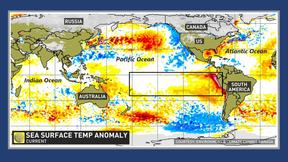
El Niño and La Niña both describe periods of prolonged water temperature anomalies in the eastern Pacific Ocean around the equator.
These anomalies can be as small as 0.5°C warmer than normal (El Niño) or cooler than normal (La Niña), but the trend has to last for about seven consecutive months in order to achieve that special milestone.
We’re coming out of a La Niña that lasted for nearly three years, a prolonged spell that’s influenced conditions across North America and several rollicking hurricane seasons over in the Atlantic basin.
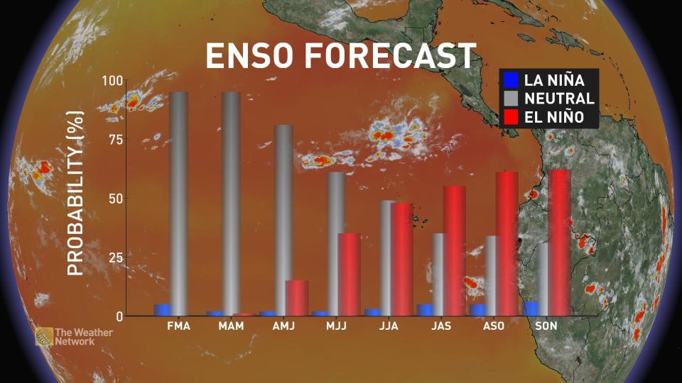
That pattern is finally coming to an end, forecasters say, and we may be on the cusp of lurching straight from La Niña into an El Niño.
The U.S. Climate Prediction Center (CPC) says that the odds of El Niño conditions setting in by this summer are greater than 50 percent, with a six-in-ten chance of an El Niño event in full bloom by the peak of hurricane season in late summer and early fall.
Such relatively modest shifts in sea surface temperatures don’t seem like much, but it doesn’t take much of a temperature difference in this part of the Pacific Ocean to have a significant impact on worldwide weather patterns.
While each event is different, forecasters can look at past El Niño events for clues about what temperature and precipitation trends we’ll see in Canada during this stretch of unusually warm water down in the Pacific.
If the forecasts hold up, we’re standing at the crossroads between two possibilities. The first is a leap straight from La Niña into El Niño, while the second is a slow and steady transition from one to the other.
A dramatic lurch could bring a cooler summer to many Canadians
If we crash straight into an El Niño fast and early this summer, it may portend a more comfortable season for many Canadians.
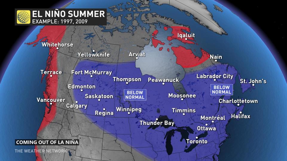
Previous summers that saw El Niño conditions begin not long after La Niña conditions ended were cooler than normal for much of the eastern half of the country. The summers of 1997 and 2009 were examples of this sudden switch.
MUST SEE: The curious case of a 'triple-dip' La Niña in a warming world
Those summers saw below-seasonal temperatures for just about everybody east of the Rockies, while folks along the immediate West Coast and in parts of the territories contended with above-seasonal temperatures.
A slow switch may lead to a steamy summer for much of Canada
However, there’s a chance we may not dive straight into an El Niño this summer. We may experience an extended period of “neutral” conditions, when water temperatures in the eastern Pacific hover right around where they should for the season.
If we see a prolonged period of neutral conditions that gradually turns into El Niño late this summer, then we could see a much different scenario play out across the country. This scenario would see the waning effects of La Niña stick around into the summer.
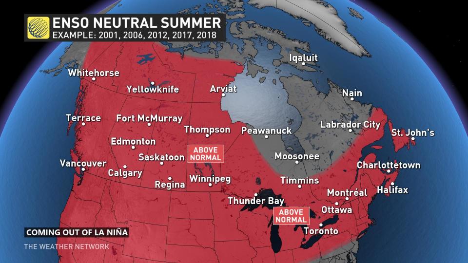
Previous years that had a similar pattern included 2012, 2017, and 2018—all seasons that saw above-seasonal temperatures across the entire country. This is the outcome you’re hoping to avoid if you’re rooting against the potential for a hot summer this year.
El Niño may affect the upcoming hurricane season
One of the most significant impacts El Niño and La Niña can have on our summertime weather happens down in the tropics.
These two patterns can heavily influence the Atlantic hurricane season through wind shear.
La Niña helps bolster hurricane activity by suppressing the destructive wind shear that tears storms apart. We saw this play out in full effect during the hyperactive seasons of 2020 and 2021.
WATCH: Experts release 2023 hurricane season forecast
El Niño increases the amount of destructive wind shear flowing east over the Atlantic, making it tougher for storms to form. If we lurch into a full-blown El Niño by this summer, it may reduce the number of storms we see form over the Atlantic this year.
However, fewer storms doesn’t mean lower danger.
The 2022 Atlantic hurricane season saw below-average activity, yet still produced widespread destruction with Hurricane Fiona and Hurricane Ian.
The summer of 1992 saw an exceptionally slow start to the Atlantic hurricane season in part due to an El Niño present through the first half of the summer. The first named storm didn’t form that year until late August. That storm was Hurricane Andrew.
Thumbnail image courtesy of NOAA.

