New heat mapping campaign could identify, solve extreme heat targeting OKC's most vulnerable
How much hotter are poorer, inner-city neighborhoods than leafy, wealthier pockets? Is climate change disproportionately impacting people in urban areas with fewer trees and less money to pay for air conditioning? What can be done to help residents in periods of extreme heat?
A new study proposed by the National Oceanic and Atmospheric Administration aims to help policymakers examine some of those questions by mapping the hottest parts of Oklahoma City, locations that are sometimes called "urban heat islands."
The campaign, which starts in May if approved by the Oklahoma City Council, will pair meteorologists from the federal agency with citizen scientists from the local metro area.
Meteorological consultants will compile the information into a report that could help local decision-makers, planners, and health organizations take action to reduce the health impacts of extreme heat, which often targets a city’s most vulnerable residents.
"The burden of heat is not shared equally in our urban areas," NOAA Administrator Rick Spinrad said in a statement announcing the study. "Gathering this type of environmental intelligence helps communities measure their hottest places so they can develop strategies to reduce the dangerous effects of heat. Community by community, we’re working to create a climate-ready nation that is resilient in a changing world."
What is an urban heat island?
An "urban heat island" is the terminology used for areas with few trees and more pavement, which allow for increased absorption of heat. These sites are often 15 to 20 degrees hotter than neighborhoods with more trees, more grass and less black asphalt.
Experts say extreme heat remains the most deadly weather-related event across the U.S. In recent years, drought and heat waves have drastically affected Oklahoma, and 2022 saw record-breaking triple-digit temperatures in Oklahoma City.
Nationwide studies show communities in the most heavily-affected areas during heat waves have seen increasingly negative effects of higher heat stroke rates in the population, poor air quality, increased financial burdens, unsuitable work and school conditions, limited access to water, and reduced crop production.
"We think that this can lead to some solutions by having some actual numbers to what we already know," said T.O. Bowman, program planner for the city’s Office of Sustainability. "If you're standing in the middle of an asphalt parking lot, you know it's going to be hotter there than it is standing in the middle of Scissortail Park. Having a number to put to that is going to be very helpful, because that will then tell us exactly what we're dealing with in the gulf of that disparity that people are experiencing."
Related: We created scorching 'heat islands' in America's biggest cities. Now they're becoming unlivable
How will the heat mapping campaign work?
Volunteer "citizen scientists" are expected to travel along designated routes throughout the city during the morning, afternoon, and evening on an especially hot day this summer, with heat sensors mounted on their vehicles. That equipment will record temperatures, humidity, air quality, timestamps, and locations.
"We'll have cooling spots and some training that will happen for volunteers, but I understand that they try to aim for about three people per route," Bowman said. "That will be a driver, a navigator, and a back-up, so just in case anything happens to either of the other two, there's somebody waiting in the wings to stand in for them."
According to the Office of Sustainability, 15 volunteers had already reached out to participate in the campaign since the announcement this month.
Bowman also said officials representing numerous organizations had expressed interest in partnering together on the project, including:
OKC Beautiful
Association of Central Oklahoma Governments
Oklahoma City-County Health Department
Southern Climate Impacts Planning Program
Oklahoma Forestry Services
EcoRise
Oklahoma Compost and Sustainability Association
Fertile Ground Cooperative
Oklahoma City Community Foundation
Department of Environmental Quality
The Oklahoma County OSU Extension Center
The Homeless Alliance
Representatives from each organization could soon comprise the mapping campaign's "steering committee," although Bowman said the total project area and any add-ons needed to be finalized first.
'A great atmosphere.' National Weather Center provides unique services to Oklahoma
What are the cities participating in the urban heat mapping campaign?
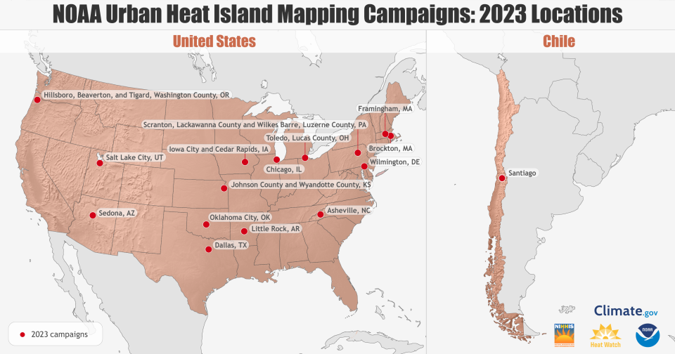
Along with Oklahoma City, communities in the U.S. chosen for the 2023 program include:
Chicago, Illinois
Salt Lake City, Utah
Dallas, Texas
Asheville, North Carolina
Framingham and Brockton, Massachusetts
Johnson County and Wyandotte County, Kansas
Wilmington, Delaware
Toledo, Ohio
Little Rock, Arkansas
Scranton and Wilkes-Barre, Pennsylvania
Sedona, Arizona
Iowa City and Cedar Rapids, Iowa
Washington County, Oregon, near Portland
Previous campaigns in other cities have also made their reports available online for review.
During last year's urban heat island campaigns, more than 780 "citizen scientists" worked with NOAA to collect over 1 million measurements in 15 different residential areas.
More: What the record-setting 2022 summer heat means for Oklahoma's future
What can the heat island mapping campaign do for Oklahoma City?
Cities from past campaigns used their heat mapping data to inform tree-planting strategies, evaluate the need and location of public transportation shelters with cooling relief, write heat action plans, and educate residents and policymakers alike with the latest research.
For Oklahoma City, Bowman said analyzing the data will prove crucial in how the city deals with increasingly scorching summer temperatures as they become the norm.
"This is another vehicle for us to bring a message about extreme heat and about changes that we know are coming," Bowman said. "We have about 9 days on average every year that reach 100 degrees or more, but we could see up to 30 of those. That's a solid month on an annual basis of 100-degree-plus weather, so we're talking Phoenix or Tucson (Arizona) temperatures at that point, and that would be Oklahoma City. And we need to be prepared, both with our infrastructure and with our public health response in how we support people whenever that happens."
ViewPoints: As we adapt to climate change, we must not forget to protect vulnerable communities in OKC
This article originally appeared on Oklahoman: New NOAA study aims to map hottest parts of Oklahoma City

