The heat wave should break Wednesday; thunderstorms, heavy rain is possible Tuesday
The heat wave should finally break after one more day of "oppressive heat and humidity" today, according to forecasters.
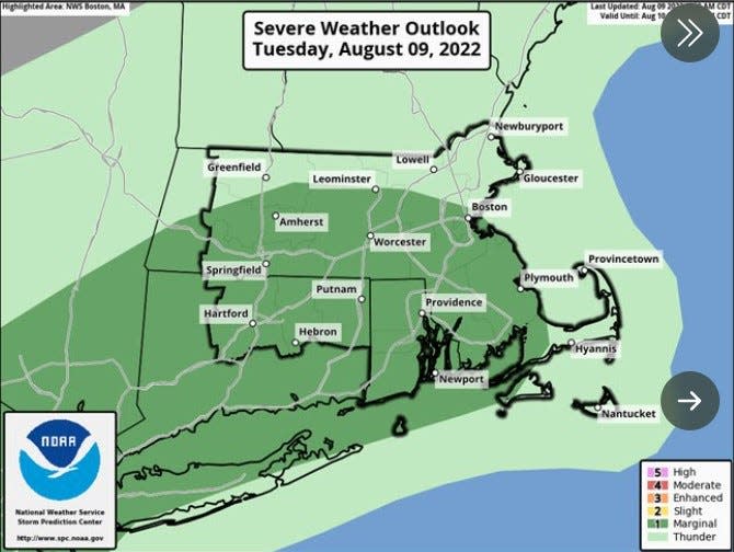
The temperature in Providence today should reach 94 degrees with heat index values as high as 105, the National Weather Service says. Showers and thunderstorms could accompany that heat. "Some of the storms could produce gusty winds and heavy rain," the Weather Service says.
A heat advisory is in effect until 8 p.m. "Drink plenty of fluids, stay in an air-conditioned room, stay out of the sun, and check up on relatives and neighbors. Young children and pets should never be left unattended in vehicles under any circumstances," the Weather Service says.
How hot is it?: Providence's treeless neighborhoods magnify summer heat
The temperature reached 95 in Providence Monday, tying a record for the date that was set in 1909.
If the temperature in Providence reache 90 or higher today, it will mark day six of the heat wave, defined as three or more consecutive days with temperatures at 90 or higher. It should also mark the last day of the heat wave. The Weather Service is forecasting a high of just 81 degrees on Wednesday and Thursday.
Throwing no shade: We created scorching 'heat islands' in East Coast cities. Now they're becoming unlivable
"A cold front brings the risk for isolated strong to severe storms this afternoon into evening, especially along and south of the Mass Pike," the Weather Service says. "The main threats are damaging winds and locally heavy downpours. Then a backdoor cold front brings in much cooler temperatures on Wednesday but humidity will remain elevated."
Tips to stay safe: Here comes the heat. Guidance on how Rhode Islanders can stay healthy and safe.
AccuWeather says a "southward dip in the jet stream will play a significant role in pulling cooler and less humid air" into the Northeast by Thursday and Friday.
A cold front could bring showers Tuesday through Thursday, and the humidity will likely linger until the front clears coastal waters Thursday night into Friday, the Weather Service says.
Expect a "pleasant stretch of weather from Friday through Monday, with comfortable humidity levels, seasonable temperatures and dry weather.
The arrival of the heat: Providence went 320 days without reaching 90 degrees. That's about to change
jperry@providencejournal.com
(401) 277-7614
On Twitter: @jgregoryperry
Be the first to know.
Sign up for our breaking news alerts
This article originally appeared on The Providence Journal: Heat wave should finally end after one more 'oppressive' day

