Heavy mountain snow is headed to Northern California. Which areas will be hit the hardest?
Northern California’s latest winter storm is forecast to bring a plethora of snow to the mountains, along with travel restrictions.
The National Weather Service announced a winter weather warning, in effect from 10 p.m. Tuesday to 10 p.m. Wednesday, for portions of the Sierra Nevada. A weaker winter storm advisory goes into effect from 10 p.m. Tuesday to 4 p.m. Wednesday for the coastal range, Shasta County mountains and Burney Basin areas.
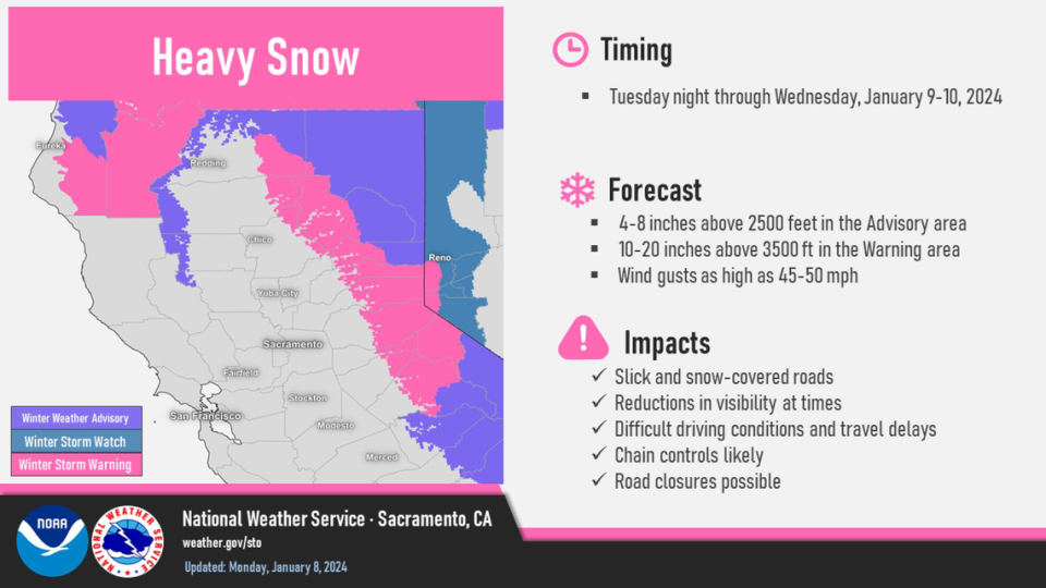
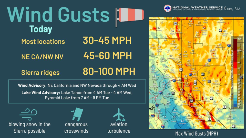
A winter storm warning also goes into effect from 4 a.m. Wednesday to 1 a.m. Thursday for the Lake Tahoe area including Stateline, Truckee, Tahoe City, South Lake Tahoe, Glenbrook, Markleeville, and Incline Village. Winds could reach up to 100 mph along Sierra ridges. The weather service also issued a lake wind advisory beginning Tuesday.
Meteorologist Katrina Hand with the weather service said the snow is expected to cause major disruptions along Highway 50 and Interstate 80 near Tahoe — travel delays, chain controls, reduced visibility and possible road closures — but it will be comparable to last weekend’s snowstorm.
“Travel could be very difficult to impossible,” the winter weather warning stated.
Are snow chains required when going to Tahoe? Here are California’s winter rules
The Truckee division of California Highway Patrol tweeted ahead of last weekend’s storm a video an apparent crash between a semi-truck and a sedan. Chain controls were at the maximum for commercial vehicles.
• I-80 is R2 in both directions from the Nevada State line to Eagle Lakes.
• Trucks are at maximum restrictions. pic.twitter.com/FPiyDc4kIU— CHP Truckee (@CHP_Truckee) January 6, 2024
According to the Tuesday weather service, elevations above 2,500 feet within the advisory area could receive between 4 and 8 inches of snow. Elevations above 3,500 feet within the warning area could see even more — 10 to 20 inches, coupled with wind gusts as high as 50 mph.
A warning suggests life-threatening conditions, the weather service stated, while an advisory indicates the weather will make travel inconvenient.
How long will the storm last?
Light rain forecast to fall in the Sacramento region this week. On Tuesday, rain in the foothills will morph into flurries. By nightfall, a bigger snowstorm will move into the Sierra.
Rain and near-freezing temperatures are in the forecast for Sacramento. Here’s when
Wednesday morning will bring the heaviest amounts of snow before the system begins to taper off in the afternoon. Lingering flurries could fall early Thursday morning before coming to a complete stop. There is some snow in the forecast for the Tahoe region headed into the weekend, beginning again on Friday.
️Heavy snow is expected in the mountains Tuesday night through Wednesday. Snow-covered roads, reduced visibility, travel delays, chain controls and road closures are all possible. Check the forecast/roads before you travel, especially to the mountains. #CAwx pic.twitter.com/KNAsySzLz2
— NWS Sacramento (@NWSSacramento) January 8, 2024
What do you want to know about life in Sacramento? Ask our service journalism team your top-of-mind questions in the module below or email servicejournalists@sacbee.com.

