High wind advisory: Gusts up to 50 mph possible in northern Ohio early Saturday
On the third day of meteorological spring Mother Nature brought wind and rain.
Like most of this past winter, Greater Akron and much of northern Ohio finds itself on the relatively warmer edge of yet another winter storm dropping heavy snow in the Upper Great Lakes.
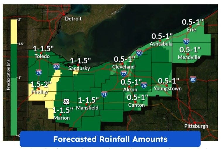
The National Weather Service says it will be a rainy Friday − as much as an inch could fall − but the real threat will be the high winds.
The weather service has issued a wind advisory for much of northern Ohio including Summit, Portage. Medina, Wayne and Ashland counties from 2 a.m. Saturday through 9 a.m. Saturday morning.
Some tree limbs may fall and power outages are possible.
It is expected to be chilly on Friday with highs in the 40s.
Some snow showers are possible Saturday morning with highs once again in the 40s.
Things warm up by Monday when temperatures are expected to reach the 60s.
Winter 2022-2023 in Ohio a warm look back
For weather nuts, meteorological spring arrived March 1.
For the rest of us who are wall calendar followers, spring arrives March 20.
Spring forward:When does daylight saving time start in 2023 in Ohio?
But for the folks at the National Weather Service, spring is already here.
And that means closing the book on meteorological winter.
It will be warmly remembered.
The weather service says it was the third warmest ever in Greater Akron with an average temperature of 36.7 degrees.
The average high was 44.2 degrees − 6.2 degrees above normal.
The average low was 29.1 degrees − 6.3 degrees above normal.
The total precipitation was 8.59 inches − some .34 inches above the norm.
Record warmth:Record warm day in Greater Akron; heavy rain and high winds expected on Friday
But this warm winter also meant less snow.
The snow total for Akron-Canton was 15.5 inches for the season − the 6th least snowiest ever.
The warmest day of winter was 72 degrees on Feb. 23 that also set a record high for that particular day.
The coldest day of winter 2022-2023 was 5 degrees below zero on Dec. 23.
Weather records for Akron go back to 1887.
What's the weather forecast?
Friday: A slight chance of rain and snow showers before 11 a.m., then rain showers. High near 44. Breezy, with an east wind 8 to 13 mph increasing to 15 to 20 mph in the afternoon. Winds could gust as high as 34 mph. Chance of precipitation is 100%. Little or no snow accumulation expected.
Friday night: Showers. Low around 33. Breezy, with an east wind 15 to 20 mph becoming west after midnight. Winds could gust as high as 34 mph. Chance of precipitation is 100%. New precipitation amounts between a half and three quarters of an inch possible.
Saturday: A chance of rain and snow showers before 7 a.m., then a chance of snow showers between 7 a.m. and 9 a.m. Mostly cloudy, with a high near 43. Breezy, with a northwest wind 16 to 21 mph decreasing to 10 to 15 mph in the afternoon. Winds could gust as high as 37 mph. Chance of precipitation is 30%. Little or no snow accumulation expected.
Saturday night: Mostly cloudy, with a low around 32. West wind around 7 mph.
Sunday: Partly sunny, with a high near 49. West wind around 7 mph.
Sunday night: Partly cloudy, with a low around 33.
Monday: A chance of showers after 1 p.m. Mostly cloudy, with a high near 61. Chance of precipitation is 30%.
Monday night: Showers likely, mainly before 1 a.m. Mostly cloudy, with a low around 39. Chance of precipitation is 60%.
Tuesday: Mostly cloudy, with a high near 46.
Tuesday night: Mostly cloudy, with a low around 28.
Wednesday: Partly sunny, with a high near 39.
Wednesday night: Mostly cloudy, with a low around 26.
Thursday: Mostly cloudy, with a high near 39.
This article originally appeared on Akron Beacon Journal: Heavy rain, high winds expected Friday as winter among warmest in Akron

