Heavy rain is on the way to South MS. How much will fall to help ease the drought?
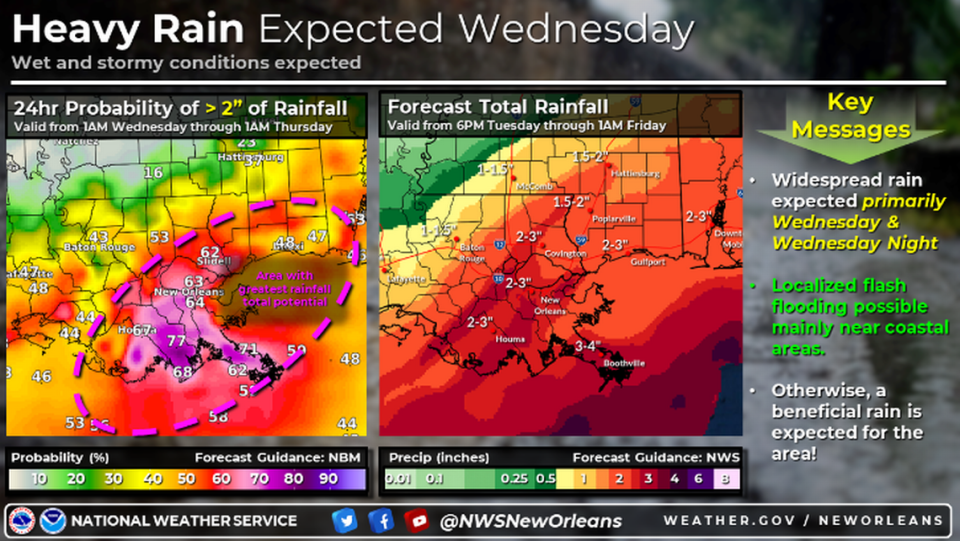
Up to three inches of “beneficial rainfall” is expected in South Mississippi this week, helping ease the drought, according to the National Weather Service in Slidell.
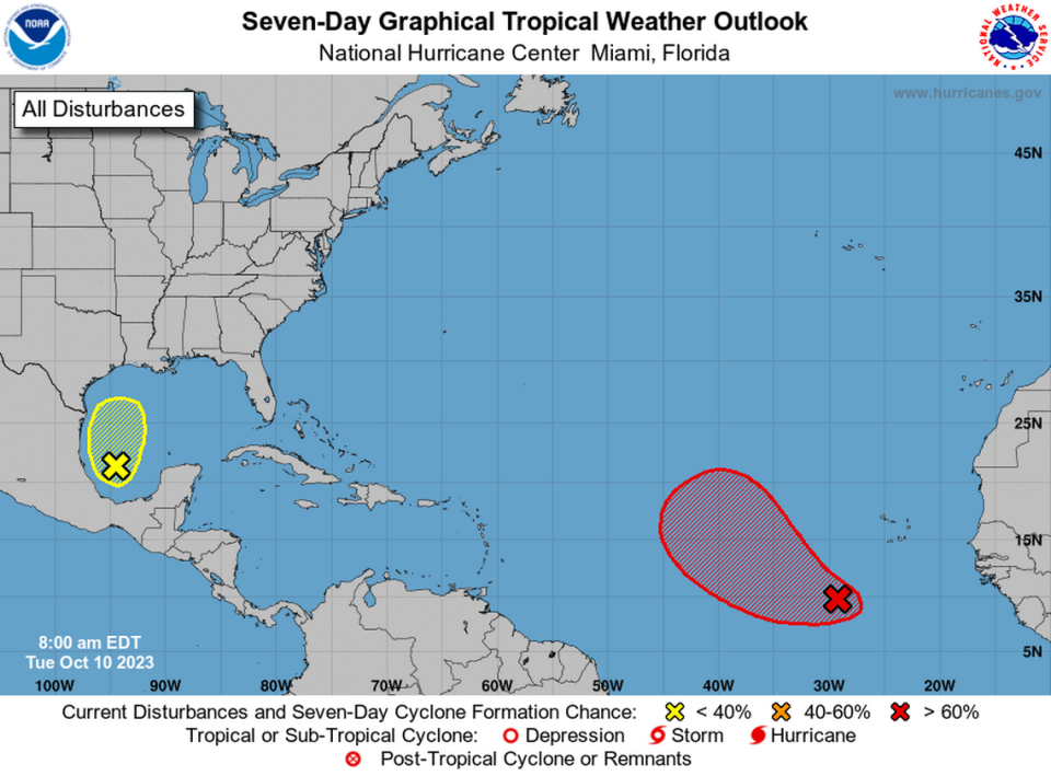
A system of low pressure in the Gulf of Mexico is expected to bring rain and gusty winds to parts of coastal Louisiana and Mississippi later this week, weather forecasters said Tuesday morning.
The system is producing disorganized showers and thunderstorms over the southwestern Gulf and is expected to move slowly north before it merges with a frontal system by Wednesday morning, National Hurricane Center forecasters said.
The system has a low chance of development and is not likely to become the Atlantic’s next named storm, hurricane forecasters said, but it is expected to cause some severe weather as it moves inland.
The rain is expected to start across the area early Wednesday, becoming more widespread in the afternoon and early overnight hours. The greatest rainfall totals will primarily be across coastal areas, with a minor risk of flash flooding.
Gusts of wind reaching up to 45 mph are expected Wednesday night. Coastal flooding, elevated tides and cross winds are also possible, forecasters said.
Disturbance near Cabo Verde
A separate disturbance in the Atlantic Ocean has a higher chance of development, the National Hurricane Center said Tuesday morning.
The broad area of low pressure southwest of Cabo Verde is expected to strengthen into a tropical depression midweek as it moves west-northwest or northwest across the eastern Atlantic, the NHC said. It has a 70% chance of forming in the next two days, forecasters said.
The current forecast track takes it away from South Mississippi. The system is still far from land, and the forecast is uncertain beyond the next few days.
The busiest time of hurricane season
We’ve well into what is historically the most active period of the Atlantic hurricane season, so consider this your reminder to get prepared and stay vigilant.
In the last 100 years, the tropics have been busiest from mid-August through October, with Sept. 10 being the peak of the season, according to federal forecasters. About 80% of the systems that have hit the Gulf Coast formed during this time, according to the National Weather Service in Slidell.
The 2023 hurricane season
The return of El Niño was initially expected to bring a wetter second half of the year to Louisiana and a reduced risk of hurricanes.
The National Oceanic and Atmospheric Association’s Climate Prediction Center announced March 9 that La Niña, which usually causes more hurricanes to form in the Atlantic, was officially over after an unusually long three years.
El Niño and its sister La Niña are part of the El Niño-Southern Oscillation cycle, a set of conditions over the Pacific Ocean that affects weather patterns across the world. In Louisiana, the biggest effects involve hurricane season in the Atlantic Ocean.
Regardless, this year’s first cyclone hit in January, long before the official start of hurricane season, and June alone saw three named storms. Now forecasters are predicting that 2023 will prove to be an above-average hurricane season, with 18 named storms.
The next storm to form will be named Sean. Here’s the full list of this year’s storm names.

