Heavy rainfall, flooding to threaten Florida Wednesday night, Thursday morning, NWS says
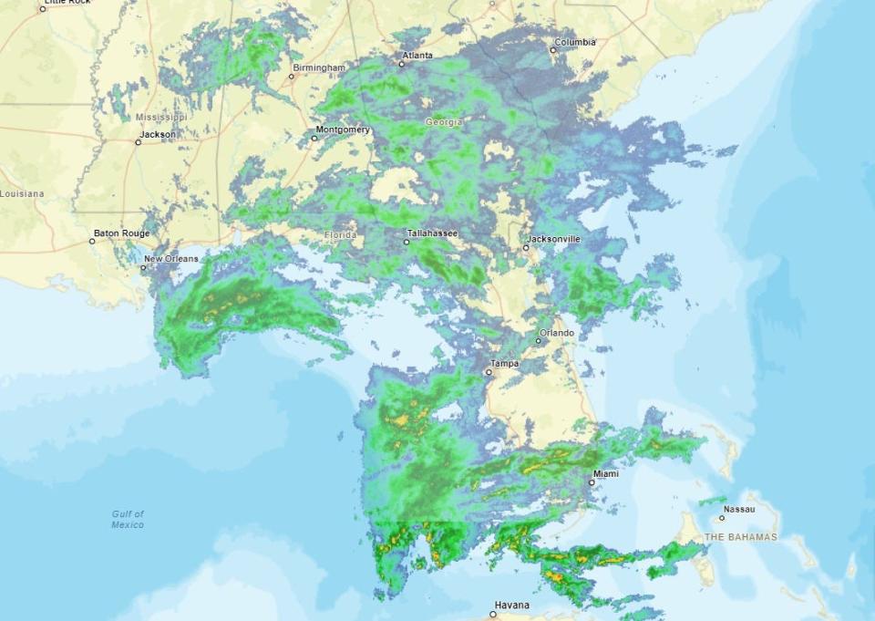
The slow-moving storm creeping across the Gulf of Mexico is expected to drench areas of Florida later today and tonight with concentrated showers and thunderstorms, and, combined with a new system developing off the southern coast, may threaten millions of people in the southern part of the state with heavy rainfall and flooding.
South Florida and most of the east coast of the state are under a flood watch through Thursday, with extremely heavy, persistent rainfall overnight that could approach or exceed 2 to 3 inches per hour, National Weather Service forecaster Andrew Orrison said. That could mean "significant urban flash flooding," he said.
"As this storm system approaches the Florida Peninsula later today and through tonight, a combination of strong energy associated with an upper-level trough and the pooling of tropical moisture along a quasi-stationary front draped near far southern Florida should set the stage for very heavy rainfall potential," Orrison said. "This will especially be the case for the highly urbanized I-95 corridor of southeast Florida from West Palm Beach and Fort Lauderdale down through Miami and Homestead."
AccuWeather Chief Meteorologist Jonathan Porter agreed, saying in a release, "Should persistent downpours with extreme rainfall rates above 1 inch per hour occur in urban areas, such as Miami and West Palm Beach, flash flooding with rapidly rising water can quickly escalate into a life-threatening situation in a matter of minutes, as urban environments have many impervious surfaces such as sidewalks and streets which promotes greater runoff."
Rainfall of 3 to 8 inches is expected, with some isolated areas approaching 10 inches by Thursday morning, according to the NWS. The weather service also warned of wind gusts of 25-35 mph with some coastal areas experiencing possible gusts over 40 mph. A high surf advisory was also issued due to high waves and the risk of dangerous rip currents.
Wed Nov 15 | Windy conditions and northward moving showers today. Advisories continue for winds, dangerous seas, surf, and rip currents. Water runup and minor beach erosion possible surrounding high tide near mid morning. Heavy rain potential for tonight, especially along coast. pic.twitter.com/BSie4AwhdW
— NWS Melbourne (@NWSMelbourne) November 15, 2023
By Thursday, the low-pressure area currently just offshore of the Florida Atlantic coast should begin to lift northward, Orrison said.
It "may still produce some additional heavy rains along the immediate east coast of Florida as onshore flow persists," Orrison said, "but the heaviest of the rains should gradually shift offshore which will allow for any additional flooding concerns to begin to gradually diminish."
Even though the spreading storms are not tropical, they attracted the attention Tuesday of the Weather Channel's harbinger of doom Jim Cantore.
If you like pounding surf and wind at the beach, this is the place to be for the next couple days. bring the rain jacket too :) https://t.co/ggLi4QcM36
— Jim Cantore (@JimCantore) November 14, 2023
Meanwhile, a low-pressure area in the Caribbean is still showing signs of forming into a tropical depression, or possibly a mix of tropical and non-tropical storms, to bring heavy rains up the nation's east coast Friday and Saturday.
Flood warning: Millions in southern Florida face flash flooding risks due to heavy rainfall, forecasters say
Is there a hurricane coming to Florida?
It won't be a hurricane, but just about the entire state can expect to see showers off and on through Thursday, according to the NWS. Heavier rainfall is expected with possible flooding for the east coast, the southern part of the state, and inland rivers.
A flood watch will be in effect from Wednesday afternoon through Thursday afternoon for east-central Florida from coastal Volusia County down to inland Martin County, with 1 to 3 inches of rain expected and locally higher amounts to around 6 inches. South Florida is under a flood watch through Thursday morning, with 3 to 8 inches of rainfall expected and locally higher amounts in excess of 10 inches, threatening flooding in urban and poor drainage areas. The Florida keys are under a coastal flood statement until 5 p.m. today.
"Excessive runoff may result in flooding of rivers, creeks, streams, and other low-lying and flood-prone locations," the NWS said. "Creeks and streams may rise out of their banks. Flooding may occur in poor drainage and urban areas. Low-water crossings may be flooded. Storm drains and ditches may become clogged with debris."
Where else and when could it flood in Florida
The NWS also has issued a flood warning through 1 a.m. Saturday for Lake and Volusia counties; a flood watch through 4 a.m. Friday for inland Miami-Dade, metro Broward and metro Palm Beach counties; a flood watch through 1 p.m. Thursday for south Miami-Dade; and a flood watch through 7 p.m. Thursday for coastal Broward, Palm Beach and Miami-Dade. There is a coastal flood advisory through 4 a.m. Friday for eastern Putnam, eastern Clay and inland St. Johns counties as well as coastal Duval, Flagler, Nassau and St. Johns counties.
A high surf advisory is in effect in northeast Florida through early Thursday morning, in south Florida and the Panhandle until Thursday morning, and east central Florida until 4 a.m. Friday with strong, rough waves between f and 9 feet tall in the surf zones in some areas. A high risk of dangerous rip currents is expected on the entire east coast through Friday, and in the Panhandle through Thursday morning.
Will it rain on Thanksgiving in Florida?
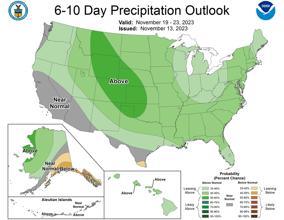
It's still a little early to predict specific temperatures and conditions, but according to NOAA's latest 6-10 day outlook there's a 33-40% chance of above-normal precipitation next week from roughly the I-4 corridor south, and an 40-50% chance of above-normal precipitation from central Florida up through the Panhandle.
Temperatures are expected to be in the 70s to low 80s with overnight temps in the 40s in North Florida and the 60s in the South.
What does AccuWeather predict for Thanksgiving weather?
For the holiday, AccuWeather is predicting temperatures in the high 60s and rain for North Florida and the Panhandle, the low 70s for Central Florida, the mid-to-high 70s and rain for Southwest Florida and the high 70s to low 80s for South Florida.
What does the Farmers Almanac predict for Thanksgiving weather in Florida?
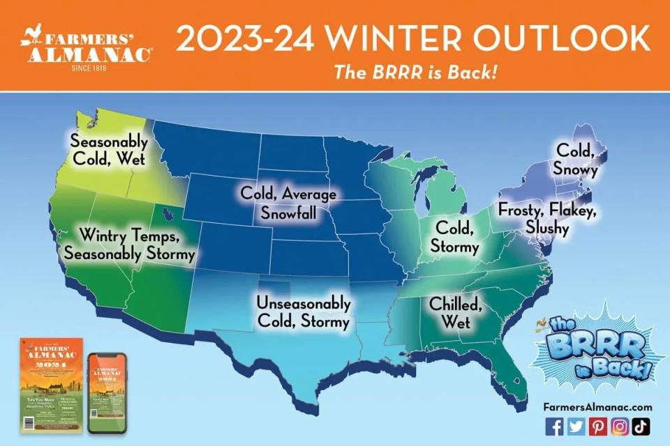
According to the Almanac, it'll be time to "cuddle up with some hot apple cider!" Conditions for the Southeast, including Tennessee, Virginia, West Virginia, North Carolina, South Carolina, Georgia, Alabama, Mississippi, and Florida, are expected to be fair but cold. "Cold" being relative for the Sunshine State, of course.
The Almanac has predicted a return to cooler weather in its 2023-2024 winter forecast, with a greater chance of rain for the southeast.
"The Southeast and Florida will see a wetter-than-normal winter, with average winter temperatures overall, but a few frosts may send many shivers to snowbirds trying to avoid the cold and snow back home," the Farmers' Almanac predicted.
The Old Farmers' Almanac, a competitor, predicts warm weather and scattered showers for Nov. 23-30.
What did the Farmers' Almanac predict for Thanksgiving weather around the country?
If you'll be traveling for the holidays, here's what you can expect to run into, according to the Farmers' Almanac:
Northeast & New England: New York, Vermont, New Hampshire, Maine, Massachusetts, Rhode Island, Connecticut, Pennsylvania, New Jersey, Delaware, Maryland, Washington D.C. should see "mostly fair but cold weather."
Great Lakes, Ohio Valley & Midwest: Ohio, Michigan, Indiana, Kentucky, Illinois, and Wisconsin may see rain and possibly snow beforehand but see a "mostly fair but cold Thanksgiving."
North Central: Missouri, Iowa, Minnesota, North Dakota, South Dakota, Nebraska, Kansas, Colorado, Wyoming, and Montana may get hit with light snow in the Rockies before the holiday, followed by a heavy snowfall in the Nebraska and Dakotas area.
South Central: Arkansas, Louisiana, Oklahoma, Texas, and New Mexico should see a "clear and cold" holiday, with some stormy weather from the west.
Northwest: Washington, Oregon, and Idaho may see "rain and wet snow."
Southwest: California, Nevada, Utah, and Arizona may be getting a "rainy Thanksgiving," the Almanac said.
This article originally appeared on The Daytona Beach News-Journal: Florida to see heavy rain, flash floods from multiple storm systems

