Heavy rainfall, tornado potential biggest threats to Treasure Coast from possible tropical storm
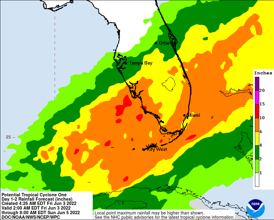
A slow-moving, potential tropical storm in the Gulf could bring “up to 12 inches” of isolated rainfall and tornado potential as forecasters said its path as of Friday shows it moving over Treasure Coast counties Saturday.
The National Weather Service Friday put Indian River, St. Lucie and Martin counties under a tropical storm warning, and the Treasure Coast and Brevard County under a flood watch into Sunday.
“It’s going to be nearly a 100 percent chance of rain,” said meteorologist Tim Sedlock, with the National Weather Service in Melbourne.
The amount of rain projected varies with the three Treasure Coast counties, but overall, there could be between 6 and 10 inches, according to the National Oceanic and Atmospheric Administration.
“Up to 12 (is) not out of the question,” Sedlock said.
Called at times a disturbance or a “large area of disorganized showers and thunderstorms,” the National Hurricane Center designated the low-pressure area a potential tropical cyclone Friday. By giving it that designation, the center can issue watches and warnings about the storm.
Pushing off the Yucatan Peninsula, Sedlock said it’s moving east over the southeastern Gulf of Mexico at three to four knots, or between roughly 3.5 and 4.6 mph.
The weather patterns are remnants of a Category 2 Hurricane Agatha that made landfall on the Pacific coast of Mexico May 30 near Puerto Angelo.
With 110 mph maximum winds, the tropical cyclone set a record as the “strongest May landfall on the Pacific coast of Mexico” since recordkeeping started in 1949, according to the NHC.
Forming in the Pacific, Hurricane Agatha preceded the June 1 start of the 2022 Atlantic hurricane season, which runs until Nov. 30. The eastern Pacific hurricane season started May 15 and also ends Nov. 30.
With a 90% likelihood of tropical storm development in a two-to-five-day timeframe, the National Hurricane Center projected the system would speed up and develop a “well-defined center” Friday to become Tropical Storm Alex and could possibly restrengthen after it moves east into the Atlantic late Saturday or Sunday.
So far, the agency stated its maximum sustained winds were near 40 mph with higher gusts.
“It’s just not well organized,” Sedlock said. “(It’s) a little tricky to get a good sense of the track.”
As of late Friday morning, he said it looked like it would move across Lake Okeechobee and over St. Lucie and Martin counties.
"(It will be a) minimal tropical storm if and when it does develop," Sedlock said. “Only time will tell."
More: Lots of rain could fall over Lake O this weekend. What does that mean for discharges?
More: Skin cancer prevention: Doctors recommend screening and sun safety as summer begins
More: Treasure Coast restaurants: What's opened, closed or moved recently?
Corey Arwood is a breaking news reporter for TCPalm. Follow Corey on Twitter @coreyarwood, or reach him by phone at 772-978-2246.
This article originally appeared on Treasure Coast Newspapers: Heavy rainfall, tornado potential biggest threats to Treasure Coast from possible tropical storm

