Heavy rains, strong winds, hail possible as more strong thunderstorms target Kansas City
Get ready to be soaked Kansas City as another round of strong thunderstorms is expected to sweep through the region on Wednesday night, according to the National Weather Service.
Before the storms’ arrival, the metro will see dry, partly sunny skies, allowing temperatures to climb into the mid-70s, a few degrees above average for this time of year in Kansas City. There is a chance for some isolated storms west of Interstate 35 in the afternoon.
Thunderstorms are expected to develop over Kansas and Nebraska during the afternoon, then track east in the evening, and continue overnight, the weather service said. Some of the storms could be strong, capable of producing hail, gusty winds, heavy rainfall and flooding.

The timing of the storms in the Kansas City area is after 7 p.m. and overnight. Up to half an inch of rain is expected in the Kansas City metro through 7 a.m. Thursday.
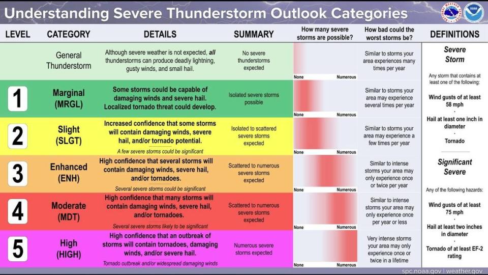
The weather service’s Storm Prediction Center has placed the Kansas City area under a marginal risk of severe weather, which indicates that severe storms could develop. Meanwhile, areas west of Kansas City are under a slight risk of severe weather.
Widespread showers and storms are possible Thursday, with hail, strong winds and heavy rains possible. Flooding will also be possible. Rain is expected throughout the day, up to 1.5 inches likely between 7 a.m. and 7 p.m.
Up to a quarter inch more rain is expected to fall overnight Thursday.
Stormy weekend likely
The metro area will finally see drier conditions on Friday, with mostly sunny skies and temperatures in the low 70s.
However, the dry weather will be short-lived. A cold front will move through the area, bringing additional showers and thunderstorms. Although these storms should not cause much of an issue, the weather service said the additional rain may not be welcomed.
The storms should exit the area Saturday morning, leaving behind partly sunny skies and temperatures near 70 degrees.
Sunday’s weather will begin mostly sunny, with temperatures climbing into the lower 70s. The chance of rain returns in the evening and continues into early Monday. Rainfall totals are expected to be meager.
Another more potent storm system is on its heels for Monday night, the weather service said.
“This will have to be monitored going forward as this would pose a significant severe threat,” the weather service said in its forecast discussion.
Weather watches and warnings
A live data feed from the National Weather Service containing official weather warnings, watches, and advisory statements. Tap warning areas for more details. Sources: NOAA, National Weather Service, NOAA GeoPlatform and Esri.

