Heavy smoke from Alisal fire hurts air quality in L.A., Orange counties as red flag warning issued
Heavy smoke billowing from the Alisal fire near Santa Barbara prompted an air quality advisory for Los Angeles and several other counties, as flames from the blaze surrounded the former vacation home of President Reagan.
Toxic plumes from the blaze — which has now burned roughly 16,800 acres — were expected to push southeast, elevating air pollution in L.A., Orange, Riverside and San Bernardino counties through at least Thursday afternoon, according to a special advisory issued by the South Coast Air Quality Management District.
SPECIAL AIR QUALITY ADVISORY: smoke from the #AlisalFire near Santa Barbara is expected to move into portions of the South Coast Air Basin and elevate air quality levels: https://t.co/Y158OoPtBX pic.twitter.com/VEqa4FneIY
— South Coast AQMD (@SouthCoastAQMD) October 13, 2021
Smoky conditions are expected along the southern Santa Barbara coast, as well as the coastal regions of Ventura and L.A. counties, according to the National Weather Service.
Areas where the smoke may waft could see their air quality index — a measurement of air pollution — reach levels "unhealthy for sensitive groups levels," the South Coast AQMD warned, advising residents in those regions to keep doors and windows shut and, if possible, run an air conditioner or air purifier.
Air quality levels were mostly "moderate" and "good" Thursday morning for the region hugging the coast between Goleta and Santa Ana. The city of Los Angeles had a rating of 54, a moderate level 1.4 times above the World Health Organization's annual air quality guideline value.
Expect smokey conditions from the #AlisalFire along the Santa Barbara south coast, as well as coastal Ventura and LA Counties, as this graphic of a smoke model shows in a forecast for Thursday afternoon. #cawx pic.twitter.com/ppoFPryTv8
— NWS Los Angeles (@NWSLosAngeles) October 13, 2021
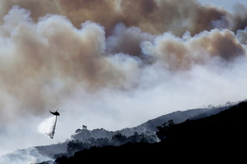
The fire that erupted Monday afternoon amid gusty winds continues to keep a stretch of the 101 Freeway closed in both directions and prompted new mandatory evacuations overnight, according to fire officials. The blaze is 5% contained and threatening about 120 homes, primarily in rural communities.
It's the first major conflagration to hit Southern California this year, and officials fear more flames will follow as seasonal Santa Ana and sundowner winds collide with historically dry fuels.
Weather officials on Thursday warned that the next few days will bring a chance of elevated fire weather, including a spike in temperatures, strong winds and bone-dry humidity. A red flag warning on the critical conditions will be in effect from 6 a.m. Friday through 8 p.m. Saturday for much of Los Angeles and Ventura counties.
Winds are forecast between 30 and 45 mph, with isolated gusts up to 55 mph. Peak gusts are expected Friday morning into the early afternoon. Humidity will likely plunge into the single digits or low teens, while temperatures surge between 80 and 90 degrees across coastal and valley areas, according to the National Weather Service.
Winds near the Alisal burn area were lighter than expected on Thursday afternoon, and crews made headway throughout the day on the blaze using aircraft, said Kristen Allison, a spokesperson for the fire. Allison expected containment to rise, but noted that the incoming red flag conditions could impact the fire area.
The fire weather warning arrives as flames from the Alisal fire encroach on Rancho del Cielo, the 688-acre ranch known as the “Western White House,” where Reagan and his wife, Nancy, played host to several world leaders. By Thursday, flames had surrounded the ranch, although there were no reports of damage to it, said Capt. Daniel Bertucelli, a spokesperson for the Santa Barbara County Fire Department.
"It remains threatened, but we have crews on scene," Bertucelli said, adding that several pieces of firefighting equipment had been stationed near the ranch since the fire broke out.
The blaze remains active on its western and northern ends, spurred by gusty northerly winds.
Along the eastern end, the area burning closest to the city of Goleta, the fire has moved into the burn scar of the 2016 Sherpa fire, which has slowed its growth, Bertucelli said. Assessment teams on Thursday were surveying potential destruction or damage to structures where the fire passed through.
Firefighters are prioritizing reopening of the 101 Freeway and nearby railway, which have been closed since the blaze started.
There is no projected reopening date for either, with "decisions made solely based off of fire behavior," Bertucelli said.
Offshore winds blowing in the Gaviota area are driving fire activity toward the freeway, causing blackout smoke conditions, he said.
"So we can't have motorists driving on the freeway," he added. "It's just not safe."
Also of concern is an ExxonMobil processing facility in nearby Las Flores Canyon, which has been out of commission since the 2015 Refugio oil spill. Infrared mapping appeared to show the fire burning into the canyon, but Exxon spokeswoman Julie King said Wednesday that no damage had been reported. The facility remains in a “safe, preserved state” and officials are watching the fire closely, she said.
The fire this week also surrounded Tajiguas Landfill, which Santa Barbara County officials noted is far more than a dump: In June, the county completed a two-year, $150-million project that transformed portions of the facility into a resource recovery center, replete with an anaerobic digester that converts methane from organic material into energy.
It’s one of about 35 anaerobic digestion projects in California, according to Santa Barbara County public works spokesman Lael Wageneck, and the energy helps power as many as 3,000 homes per year.
But on Tuesday, areas of the landfill smoldered and burned after a flare-up ignited in the biofilter’s uncovered concrete structure, which is filled with wood chips. The Alisal fire also damaged drainage, landfill gas collection systems and heavy equipment, Wageneck said, although a complete damage assessment remains ongoing. County officials have implemented a contingency plan that will send waste from the area to facilities in Ventura County on a short-term basis, he said.
Meanwhile, some environmental groups are watching the fire closely as it burns into chaparral ecosystems and around a rare plant species known as Refugio manzanita. The shrubs are endemic to Santa Barbara County and found only between 1,000- and 3,200-foot elevations in the Santa Ynez Mountains, according to Los Padres ForestWatch.
They are so valuable that the environmental groups, along with the California Chaparral Institute, fought a 2015 Forest Service proposal to create a fuel break along the crest of the Santa Ynez Mountains, fearing it would shred the Refugio manzanita and cause irrevocable damage to the fire-adapted landscape.
The Forest Service, which classifies the Refugio manzanita as a sensitive species because of its dwindling population, canceled that portion of the plan, said Andrew Madsen, a spokesman for the Los Padres National Forest, but continued with other fuel management projects in the area.
This story originally appeared in Los Angeles Times.

