Intense winds prompt power outages across B.C. heavy snow impact highways
Widespread warnings remain in effect across British Columbia as a powerful system brings heavy snow and the threat for damaging winds. The winter storm has cancelled ferry crossings and prompted avalanche warnings.
GET THE LATEST: Winter returns with a rare El Niño chill coming to B.C.
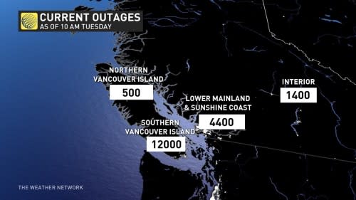
Power outages swept across B.C. as a windstorm peaks Tuesday along with persistent highway pass snowfall. Powerful winds left over 20,000 people without power Tuesday afternoon, with many seeing their power restored by the evening hours.
Tuesday into Wednesday: Dangerous travel as heavy snow falls over the highway passes
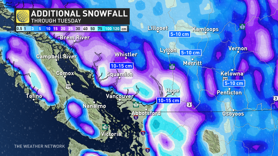
Snow will continue to fall above 600 m, with freezing levels remaining relatively low for the next few days. That means very heavy snow will pick up for the highway passes, with between 40-60 cm possible through the day on Wednesday.
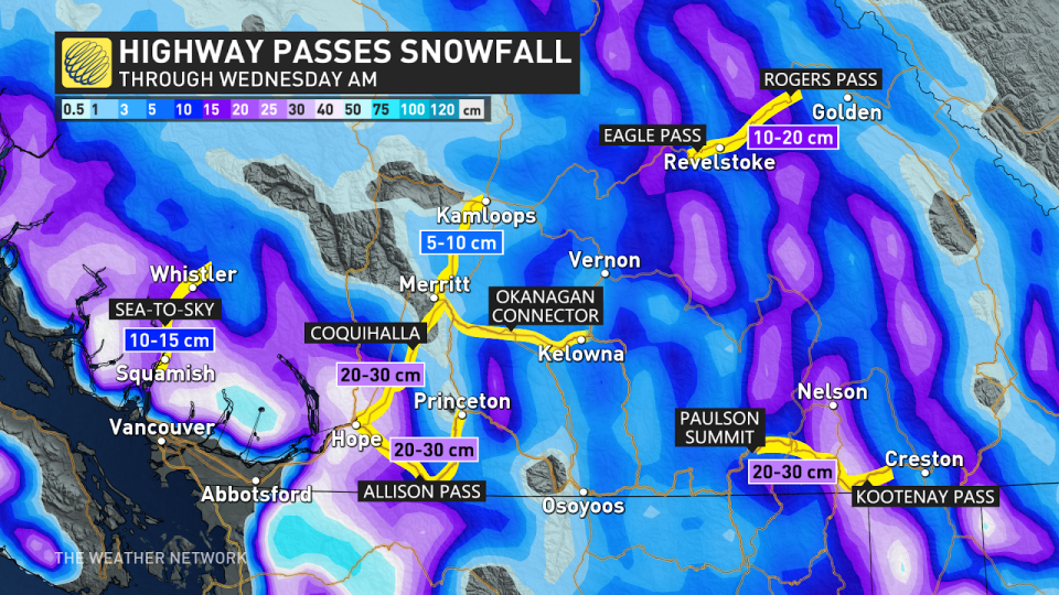
This will make for extremely tricky driving along Coquihalla Highway, and drivers are being urged to adapt to the quickly changing conditions. Visibility may be suddenly reduced at times in heavy snow.
There's a chance for accumulating snow across the Interior and the Okanagan as well, with 5-15 cm forecast, on top of the snow that already fell into Tuesday morning. Snowfall and winter storm warnings remain in effect.
DON'T MISS: Winter to finally show up in January as El Niño bested by polar vortex
Avalanche Canada is of "very dangerous" avalanche conditions at higher elevations across southwestern B.C. where heavy snowfall and extreme winds are building reactive storm slabs. Travel in avalanche terrain is not recommended, officials say.
Damaging wind threat with climbing outages likely
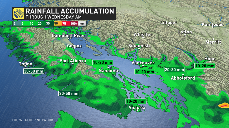
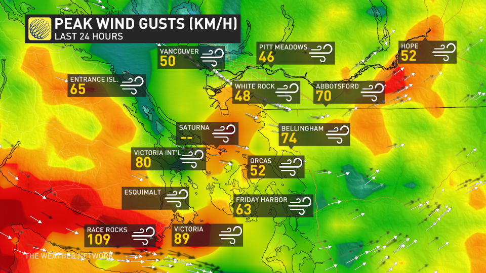
Rain and gusty winds will continue to impact inland sections of the Lower Mainland and south Vancouver Island as the cold front passes through on Tuesday. Gusts over 100km/h have already been reported in Race Rocks, and Victoria saw wind gusts close to 90km/h on Tuesday.
Afternoon wind gusts are expected to be the strongest as a front funnels in winds from the northwest, right through the Juan de Fuca.
Perfect alignment of the low level jet through the strait of Juan De Fuca. Race Rocks will be screaming later Tuesday. There's also a compelling case for some lightning to develop. #BCStorm pic.twitter.com/DVYP2U2z5g
Perfect alignment of the low level jet through the strait of Juan De Fuca. Race Rocks will be screaming later Tuesday. There’s also a compelling case for some lightning to develop. Tyler Hamilton on Twitter: "Perfect alignment of the low level jet through the strait of Juan De Fuca. Race Rocks will be screaming later Tuesday. There's also a compelling case for some lightning to develop. #BCStorm pic.twitter.com/DVYP2U2z5g / Twitter" Tyler Hamilton on Twitter: "Perfect alignment of the low level jet through the strait of Juan De Fuca. Race Rocks will be screaming later Tuesday. There's also a compelling case for some lightning to develop. #BCStorm pic.twitter.com/DVYP2U2z5g / Twitter"
— Tyler Hamilton (@50ShadesofVan) Tyler Hamilton on Twitter: "Perfect alignment of the low level jet through the strait of Juan De Fuca. Race Rocks will be screaming later Tuesday. There's also a compelling case for some lightning to develop. #BCStorm pic.twitter.com/DVYP2U2z5g / Twitter"
Ferry cancellations and climbing power outages will be felt through Tuesday until winds ease overnight. There's even the threat for lightning during Tuesday, as well.
Concerning cold will ooze across western Canada, with an arctic outflow event closing out the week in B.C.
Stay with The Weather Network for more forecast information and updates as we monitor your weather across B.C.

