Heavy surf pounds Bermuda as Hurricane Lee continues to churn
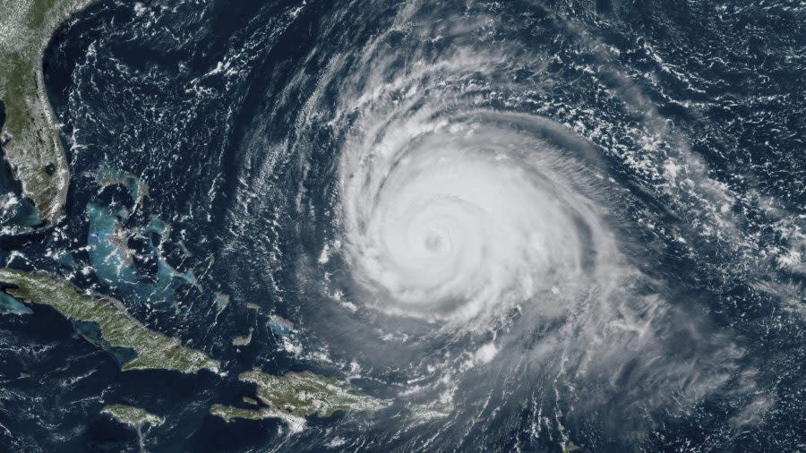
SAN JUAN, Puerto Rico (WFLA) — The outer bands of Hurricane Lee began to lash Bermuda late Thursday as big surf pounded the island, with the Category 2 storm expected to make landfall on the coast of New England or Atlantic Canada over the weekend.
The storm was located about 295miles south-southwest of Bermuda. It had winds of up to 100 miles per hour and was moving north-northwest at 9 mph.
National Hurricane Center tracking Lee, Margot and a disturbance with a 90% chance of formation
Lee was expected to pass just west of Bermuda, prompting forecasters to issue a tropical storm warning for the island.
”I cannot stress enough that we must all take this storm seriously,” David Burch, acting national security minister, said in a press conference.

Bermuda’s government announced it would shutter its airport at midday Thursday and reopen it Friday. Banks, city parks and ferry service also were scheduled to shut down Thursday. Public schools would shutter Thursday and Friday.
“We don’t want 4,000 little people wandering around the country in tropical storm winds,” Burch said.
Lee is expected to grow in size and keep traveling north as it slowly loses strength in cooler waters. It is forecast to approach the coast of New England and Atlantic Canada on Friday and Saturday and remain a “large and dangerous hurricane,” according to the National Hurricane Center.
A hurricane watch was issued from Stonington, Maine to the U.S.-Canadian border. A tropical storm watch was issued for a large swath of coastal New England from Watch Hill, Rhode Island to Stonington, Maine, including Block Island, Martha’s Vineyard and Nantucket. A storm surge watch was issued for Cape Cod Bay and Nantucket.
“Due to Lee’s large size, hazards will extend well away from the center, and there will be little to no significance on exactly where the center reaches the coast,” the center said.
Hurricane-force winds extended up to 105 miles from Lee’s center, and tropical-storm-force winds extended up to 290 miles, the center reported. It warned of wind, rain and coastal flooding for parts of New England and Atlantic Canada.
The storm is approaching as New England struggled on Wednesday with flooding from unusually heavy rainfall unrelated to the hurricane that prompted the governor of Massachusetts to declare a state of emergency.
Forecasters warned of dangerous surf and rip currents in Lesser Antilles, the British and U.S. Virgin Islands, Puerto Rico, Hispaniola, the Turks and Caicos Islands, the Bahamas, Bermuda and the U.S. East Coast. The conditions were starting to reach Atlantic Canada.
“I understand our community has been through a lot with back-to-back storms,” Burch said, referring to Idalia, which spun past the island on Saturday as a post-tropical cyclone and has since dissipated. “I want to acknowledge the fatigue and concern many of you may be feeling right now.”
Hurricane Margot
Hurricane Margot is forecast to meander within weak steering currents on Friday and make a small clockwise loop over the weekend.
The storm’s winds are near 75 mph, with higher gusts. It’s located about 745 miles west of the Azores.
It is the 13th named storm of the Atlantic hurricane seasons and the fifth hurricane to form. The season runs from June 1 to Nov. 30 and peaked on Sunday.
Disturbance in Atlantic
The NHC is monitoring a disturbance that is likely to become a tropical depression in a few days.
An area of showers and thunderstorms near the Cabo Verde Islands is gradually becoming better organized.
Forecasters give the system an 80 percent chance of development over the next two days and a 90 percent chance of development over the next seven days.
The National Oceanic and Atmospheric Administration has forecast 14 to 21 named storms this season. Six to 11 of those are expected to strengthen into hurricane, and of those, two to five could develop into Category 3 storms or higher.
The Associated Press contributed to this report.
For the latest news, weather, sports, and streaming video, head to WesternSlopeNow.com.

