Here's How Aliens Might See Earth
Cornell researchers have released a working concept of what Earth may look like from other exoplanets.
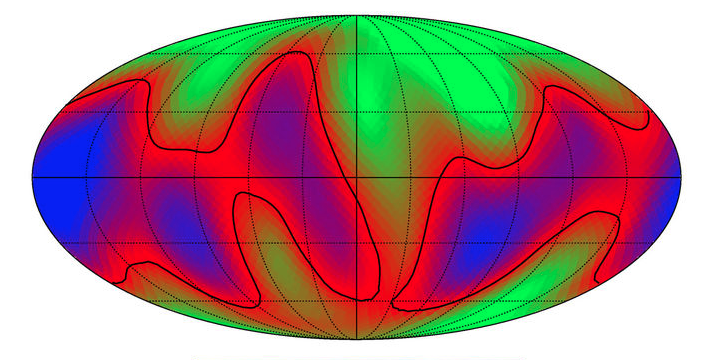
The two-dimensional alien map in the image above depicts Earth as an exoplanet.
To make the map, the researchers captured about 10,000 images of Earth from NASA's Deep Space Climate Observatory satellite.
Humans are narcissists when it comes to space. Earth is the center of the universe because, well, we live on it.
While astronauts have seen the blue planet first-hand from the vacuum of space, we still have no idea how other potential lifeforms view our little blueberry of a home.
However, researchers from Cornell have released a working concept of what Earth may look like from other exoplanets, or planets that exist outside of our solar system and orbit around stars other than our sun. In this paper, they've constructed what they call "a two-dimensional alien map," imagining that Earth is the exoplanet. That's the map in the image above.
To find exoplanets that may be able to support human life, astronomers peer through telescopes that barely show them a single dot of light. To learn more about these spots of light, the Cornell team decided to reverse the problem by taking images of an already inhabitable planet, Earth, and drawing up an image of something an alien astronomer may see light-years away.
They began by capturing about 10,000 images of Earth from NASA's Deep Space Climate Observatory satellite. It sits at a gravitational balance point between Earth and the sun, meaning that the satellite only sees the daytime side of the planet. The astronomers captured the images every one or two hours at 10 specific wavelengths throughout 2016 and 2017.
To recreate an alien point-of-view, researchers downsized all of those images into a single brightness reading for each of the 10 wavelengths that they recorded, resulting in 10 dots. When those are plotted over time, they create light curves that illustrate what an alien observer may see if they were watching Earth from afar for two years.
Once Cornell researchers determined which curves corresponded to land or clouds by comparing them to the original images, they were able to build the 2D contour map seen above.
The black lines on the map show median values for land and, in effect, serve as approximations of where coastlines are. You can see a rough outline of Africa at the center and the Americas on the left, for example.
This tactic could prove fruitful in the future if similar images are taken of exoplanets outside our solar system, helping astronomers map out oceans, icecaps, and clouds that are all necessary for a habitable world.
"This study serves as a baseline for reconstructing the surface features of Earth-like exoplanets in the future," the authors write.
Source: Cornell University
You Might Also Like

