UPDATE: 'More concern' for severe weather this evening, overnight in Tri-State
The National Weather Service says two rounds of thunderstorms could roll through the Tri-State Tuesday evening and overnight, and some of them are likely to be severe.
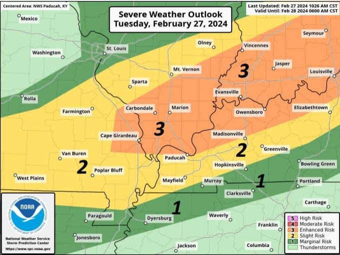
In a midday briefing, officials with the weather service's Paducah, Kentucky, office, which monitors conditions in Evansville and Henderson, noted that the region had been upgraded to an "enhanced risk" zone. An "enhanced risk" means that numerous severe storms are possible, and that some of the storms could be long-lived, with a few intense storms possible.
There had previously only been a "slight risk" for area, but was changed midday as new models suggested more intense thunderstorms.
Timing of severe weather in Evansville/Henderson
Sean Poulus, a National Weather Service meteorologist, said that the first round of storms will move through the northern half of the Tri-State − including Evansville and Henderson − between 7 p.m. and 11 p.m.
A cold front will move through the same area between 11 p.m. and 3 a.m., bringing more a potential for more severe weather.
Warm weather, strong winds during the day
Strong southerly winds are expected throughout the Tri-State today, gusting at times to 40 mph. They'll continue into the evening ahead of a cold front that is moving toward the Ohio Valley.
A wind advisory is in effect until 3 a.m. Wednesday. Forecasters warn that the winds could blow around unsecured objects and cause a few power outages. Travel could be impacted, especially for high-profile vehicles such as semis.
The peak wind gusts are expected in the afternoon and early evening hours across the region.
There is a small (less than 15 percent) chance of rain during the day on Tuesday, and it will be a cloudy day. It also will be warm. The high temperature is expected to reach 77 degrees, which would tie the record for Feb. 27, last set in 1996.
Much colder after the storms
How's this for a temperature drop? The National Weather Service expects it to be 70 degrees in Evansville at 11 p.m. Tuesday. By 8 a.m. Wednesday, it will be around 30 degrees. That's a 40-degree drop in a nine-hour span as winds turn to the northwest.
Those winds will remain gusty for much of the day ednesday, taking wind chills into the teens at times.
A warm-up begins Thursday with a high temperature of 46. It'll be 51 on Friday, 65 on Saturday and 73 on Sunday.
Rain returns to the forecast Monday, though highs will still be in the lower 70s.
This article originally appeared on Evansville Courier & Press: Will it storm today in Evansville and Henderson?

