Here's who got the most snow in Northern Colorado over the weekend
Fort Collins woke up to a thin blanket of snow on Saturday morning, while parts of Weld County were looking at a layer more like your overstuffed down comforter.
Data provided by weather watchers to the Community Collaborative Rain Hail and Snow Network, or CoCoRAHS, showed Fort Collins received anywhere from half an inch to 2.5 inches of snow.
But over in Weld County, there were reports of up to 13.5 inches of snow around Greeley and Evans, according to reports to CoCoRAHS and the National Weather Service.
There, the snow fell intensely in a short period Friday night. Snowfall reports were as high as 12 inches by 1:30 a.m.
Saturday's forecast indicated there was a chance for a few more flakes to fall in the Fort Collins area, but not more than an inch, according to the National Weather Service.
A morning post from the NWS Boulder on X.com said the snow would move south and east of Denver and north of Fort Morgan to the Nebraska panhandle.
The forecast through Wednesday
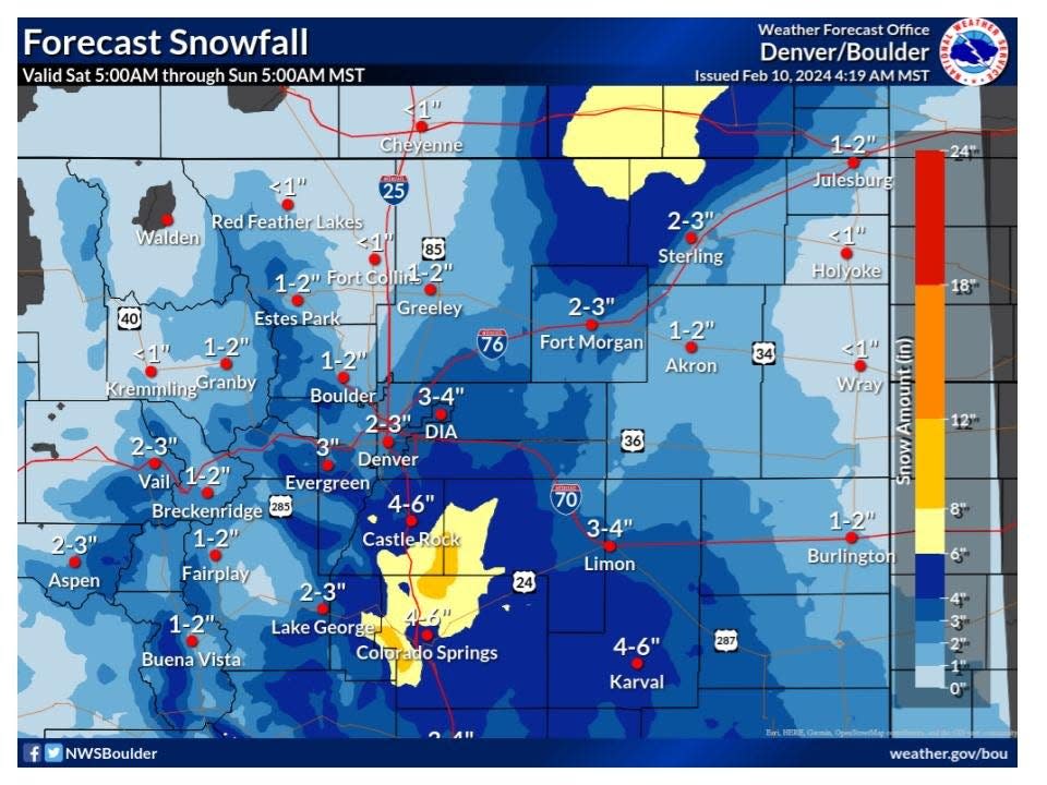
Saturday: A 50% chance of snow. Cloudy, with a high near 33. Winds could gust as high as 16 mph. Total daytime snow accumulation of less than a half inch possible.
Saturday night: A 40% chance of snow before midnight. Cloudy, then gradually becoming partly cloudy, with a low around 14. Winds could gust as high as 16 mph. New snow accumulation of less than a half inch possible.
Sunday: Sunny, with a high near 41.
Sunday night: Partly cloudy, with a low around 19.
Early in the work week, you can expect sunny skies with highs in the upper 40s and lows in the lower 20s, according to the NWS forecast.
Reported snow totals
Reports to the Community Collaborative Rain, Hail and Snow Network on Saturday morning:
Fort Collins: 0.5 to 2.5 inches
Loveland: 1.3 to 3.3 inches
Denver: 1.5 to 2 inches
Boulder: Less than an inch
DIA: 2.2 inches
Broomfield: 3.3 inches
Thornton: 3.6 inches
Lakewood area: 3.8 to 7.5 inches
Evergreen area: 4.8 to 7.5 inches
Wheat Ridge: 6.5 to 7.5
Golden area: 8.5 inches
Eaton: 8.8 inches
Greeley: 9 to 13.5 inches
This is Greeley's biggest snowstorm since Oct. 2009, per UNC co-op data.
Greeley saw 12" of snow in less than six hours between 8pm-1:30am!#9wx #COwx pic.twitter.com/ZkkeDU72ht— Chris Bianchi (@BianchiWeather) February 10, 2024
This article originally appeared on Fort Collins Coloradoan: Fort Collins gets Colorado snow, but Weld County gets lots of it

