Here's where tornadoes struck in Indiana during the March 31 storm
UPDATE: On Monday, the National Weather Service announced on Twitter that the tornado in Colfax had been adjusted to an EF2; and the Whiteland tornado to an EF3.
After further assessment on a few damage points, we've adjusted the EF1 tornado in Colfax to now be an EF2 with max wind speeds of 120 mph. The Whiteland tornado is now an EF3 with max winds of 140 mph. #INwx
— NWS Indianapolis (@NWSIndianapolis) April 3, 2023
More than a dozen tornadoes touched down to cause deaths and property damage across the state on Friday, March 31. The National Weather Service is still compiling its list of tornado reports.
Here is a list of those reported, which was at 17 as of 8 p.m. April 2. All information is provided by the National Weather Service and is considered preliminary.
Indiana weather: More tornadoes possible in Central Indiana as storms move in April 5
Badger Grove in White County
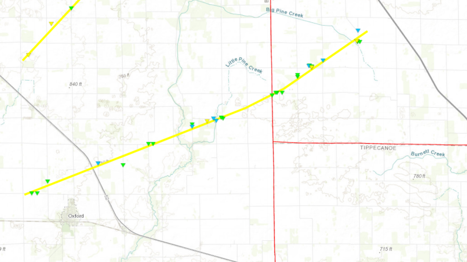
Time: 9:33 p.m. to 9:47 p.m.
EF rating: EF-2
Peak winds: 115 mph
Path length: 15.18 miles
Max width: 400 yards
Deaths/injuries: 0/0
Summary: Primarily downed trees, power poles, and damaged farm outbuildings, however there were several homes damaged, 2 significantly. The tornado began in Benton County, IN and tracked into White County, IN with the ending of the tornado 4 miles northwest of Badger Grove, IN.
Indiana weather forecast: Severe storms, including possible tornado threat, expected Tuesday in Central Indiana
Smithson in White County
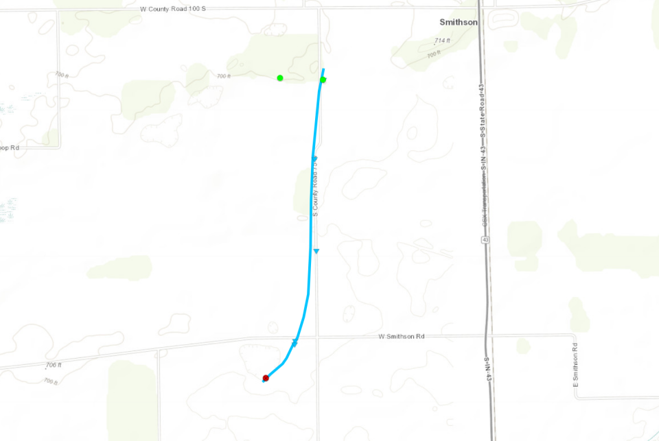
Time: 9:55 p.m. to 9:58 p.m.
EF rating: EF-0
Peak winds: 85 mph
Path length: 1.29 miles
Max width: 125 yards
Deaths/injuries: 0/0
Summary: A tornado touched down in an open field south of West Smithson Road and west of South CR 75W. A wind turbine blade was bent over and another snapped off as it moved quickly NNE causing significant damage to a pole barn and throwing two empty silos into a field north of Smithson Road. The tornado paralleled County Road 75 causing minor damage before lifting south of County Road 100 S. Maximum winds are estimated at 80 to 85 mph with a width of 125 yards. A wind speed rating cannot be assigned to the turbine blade, but the speed could be higher than the estimated range.
Royal Center in Cass County
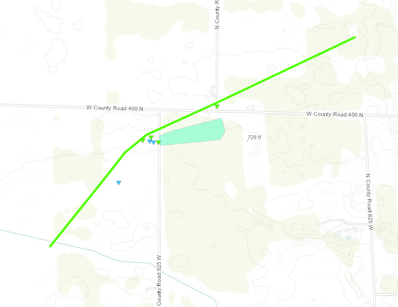
Time: 10:13 p.m. to 10:16 p.m.
EF rating: EF-1
Peak winds: 100 mph
Path length: 1.73 miles
Max width: 300 yards
Deaths/injuries: 0/0
Summary: An NWS storm survey confirmed a tornado touched down in an open field south of W CR 400 N, between N CR 1000W and 925W. It quickly tracked northeast, flipping 8 spans of a center pivot irrigation system once. It also destroyed 2 large pole barns at a residence near 400N and 925W. Several trees were snapped and corn fodder from the field was pulled into the yard and extended northeast from there. The back garage portion of a home was damaged. Power poles were also snapped in the area. The tornado made a turn to the right and began to weaken, striking a home at the intersection of W CR 400 N and N CR 900 N where the roof on the southwest side of the home was lifted, several smaller trees were also uprooted and a fuel tank was rolled into the field to the northeast. Debris was carried for a few more miles to the northeast. The track of the tornado may have continued further northeast but it weakened significantly after the noted damaged areas.
Sullivan in Sullivan County
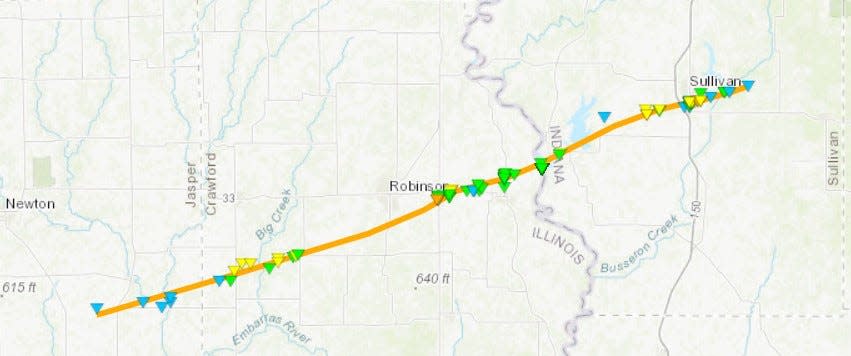
Time: 10:21 p.m.
EF Rating: Preliminary EF-3
Peak winds: 155 mph
Path length: 8.94 miles
Max width: TBD
Deaths: 3; injuries: 8
Summary: The survey team determined the tornado crossed the Wabash River and entered Sullivan County east northeast of Merom. Near Merom, the tornado severely damaged three homes and destroyed a modular home, which was thrown at least 200 yards to destruction. Two occupants of this home were killed. Furthermore, a large trailer and several cars were thrown tens of yards from their resting location. Many trees were sheared approximately 20 to 30 feet off the ground. The tornado continued across the southern parts of the City of Sullivan. Homes and structures were severely damaged or destroyed. The tornado continued to locations southeast of Sullivan, again destroying at least three homes, including one modular home, which was thrown at least 150 yards. One occupant of this home was killed, while the other was injured. Again, many trees were sheared 20 to 30 feet off the ground. Farther east the tornado began to weaken and continued into a wooded area, damaging numerous trees before lifting off the ground. Much damage in the area reached the EF-2 scale level (111-135 mph) with several locations where winds reached the EF3 scale level (136-165 mph).
Sullivan County aftermath: Mother and son die after tornado picked up house, slammed it to the ground
Near Colfax in Clinton County
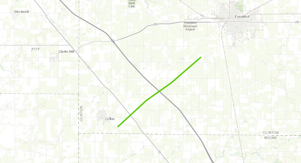
Time: 10:45 p.m.
EF rating: EF-2
Peak winds: 120 mph
Path length: 6.79 miles
Max width: 100 yards
Deaths: 0; Injuries: 1
Summary: The tornado began initially southeast of Colfax and impacted a large homestead with a barn and toppled a large radio tower. The tornado then moved through portions of rural southwestern Clinton County causing damage to several farmsteads. A few barns between US-52 and I-65 were completely destroyed. The tornado only caused minor damage for a short period of time before doing additional significant damage southwest of Frankfort.
McCormick’s Creek in Owen and Monroe counties
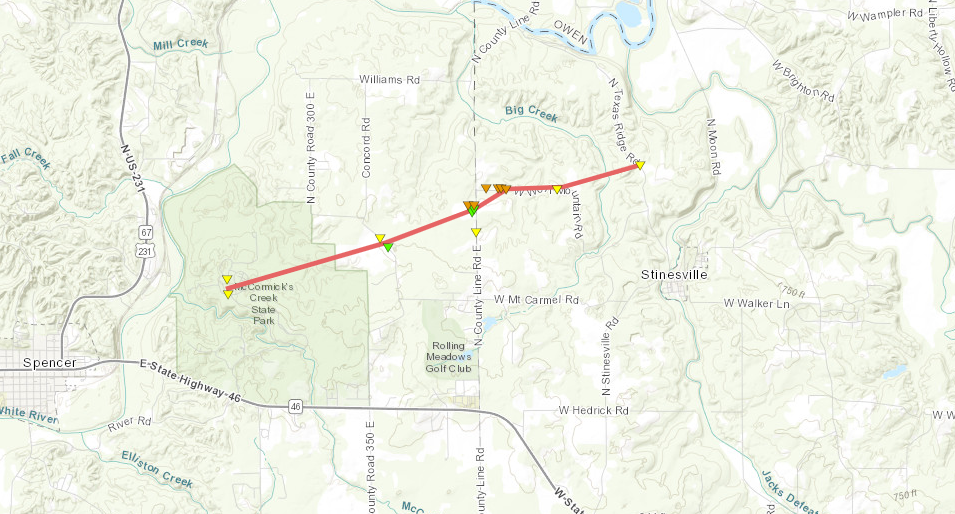
Time: 11:01 p.m.
EF rating: EF-3
Peak winds: 138 mph
Path length: 4.01 miles
Max width: 400 yards
Deaths: 2; Injuries: 2
Summary: The tornado began in McCormick's Creek State Park, and then continued northeast into extreme NE Owen and NW Monroe counties. While here, many hardwood trees were snapped and some debarking was observed. In this area, a few homes were badly damaged or destroyed. The tornado then continued producing additional roof and tree damage for another mile. Fatalities were in McCormick's Creek State Park. Max width was observed near County Line Road between Owen and Monroe counties.
Two killed: Rossville couple killed at McCormick’s Creek State Park, raising Indiana death toll to 5
South of Russiaville in Howard County
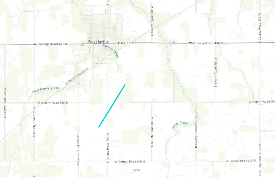
Time: 11:11 p.m.
EF rating: EF-0
Peak winds: 80 mph
Path length: 0.86 miles
Max width: 10 yards
Deaths/injuries: 0/0
Summary: A tornado touched down in a field with a few trees. The tornado then impacted a home causing tree and barn damage. One treetop was pulled back toward the home to the southwest. The tornado then quickly lifted in a farm field nearby.
Near Russiaville in Howard County
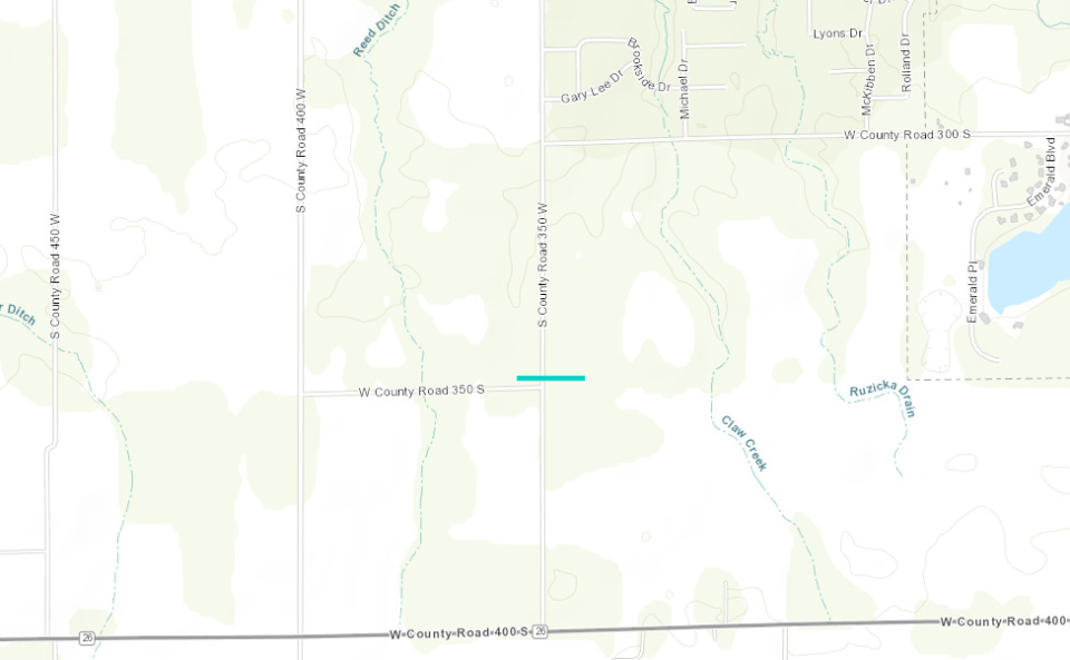
Time: 11:15 p.m.
EF rating: EF-0
Peak winds: 80 mph
Path length: 0.14
Max width: 10 yards
Deaths/injuries: 0/0
Summary: Damage to an outbuilding west of the first damaged homestead. The aforementioned homestead had shingle damage and a playground set thrown northeastward. Trees near the playground in the backyard fell toward the east-southeast. Further damage occurred east of 350W to an attached garage along with a few small sheds. At this site, a car was moved/turned 45 degrees, a large piece of plywood was stuck between remaining tree branches, and wooden splinters were observed driven into siding.
Near Greentown in Howard County
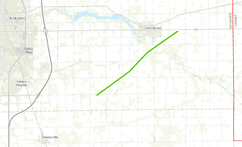
Time: 11:20 p.m.
EF rating: EF-1
Peak winds: 110 mph
Path length: 6.41 miles
Max width: 25 yards
Deaths: 0; Injuries: 1
Summary: The tornado began in a rural field south of a homestead with two barns, a home and a mobile home. One small barn was completely destroyed along with the mobile home, which caused a serious injury. The home and larger barn had lesser damage. This tornado continued to do tree, barn and home damage to farmsteads to the northeast. The tornado continued into a larger neighborhood near County Road 100S, where it mainly did roof and tree damage to tree rows.
Near Martinsville in Morgan County
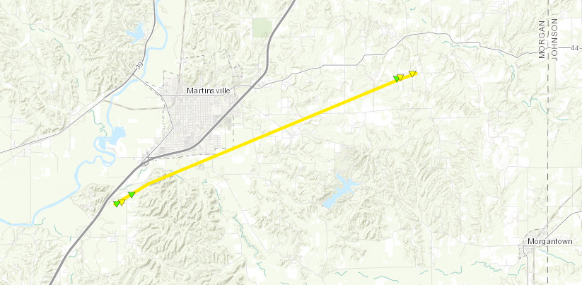
Time: 11:21 p.m.
EF rating: EF-2
Peak winds: 130 mph
Path length: 8.6 miles
Max width: 200 yards
Deaths/injuries: 0/0
Summary: A subdivision near Highway 37 had numerous homes with considerable roof damage, and an empty grain bin was lofted and displaced. The top of the grain bin was torn off. Heading northeast there was sporadic tree damage. Next structural damage was observed along Rolling Hills Drive. A pontoon boat was lofted across the lake. This pontoon boat was lofted over another house reaching about 1/4 mile in distance from its original location to the resting point.
Near Bargersville in Johnson County
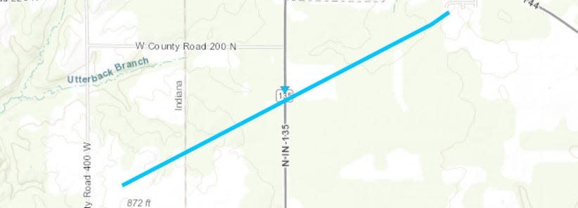
Time: 11:27 p.m.
EF rating: EF-0
Peak winds: 85 mph
Path length: 1.93 miles
Max width: 25 yards
Deaths/injuries: 0/0
Summary: Sporadic tree damage was noted in the town of Providence, which were mainly straight-line winds. The tornado began to form to the N/NE of Providence where slightly more intense tree damage was noted. The tornado continued to move E/NE and crossed State Road 135 between W Rd 100 N and W Rd 200 N. Multiple power lines were damaged and laying across 135. Metal roofing of a barn just east of 135 was peeled back suggesting winds upwards of 85 mph. The tornado continued moving E/NE toward IN-144 but lifted just before reaching IN-144. Sporadic tree damage was noted to the south of IN-144.
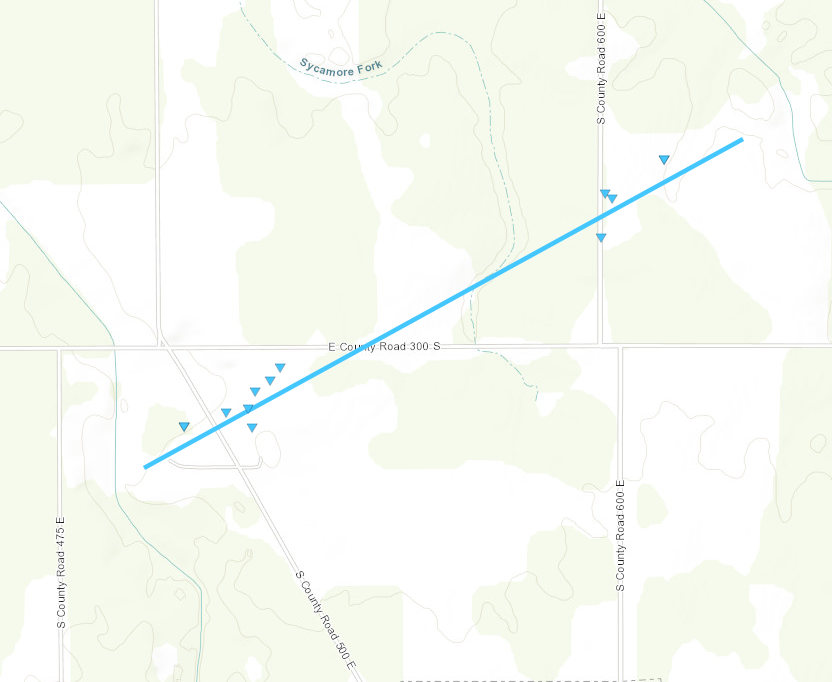
Near Whiteland in Johnson County
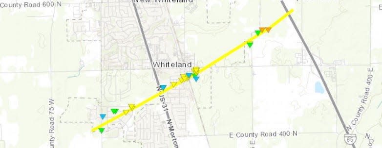
Time: 11:33 p.m.
EF rating: EF-3
Peak winds: 140 mph
Path length: 3.54 miles
Max width: 316 yards
Deaths/injuries: 0/0
Summary: The storm continued moving northeast and a tornado redeveloped in an open field just to the west of the Park Forest neighborhood. The tornado moved through the neighborhood where EF-0 to EF-1 damage was noted initially. The tornado intensified as it moved through the neighborhood and produced low-end EF2 damage. A cell tower near Whiteland Sewer Department just to the NE of the neighborhood sustained damage as the tornado continued moving northeast toward US Highway 31. Once the tornado crossed Highway 31 it moved through a neighborhood near Briar Hill Drive. High-end EF-1 to mid-range EF-2 damage occurred from Pinedale Drive to Forum Drive. The tornado continued to strengthen as it moved northeast, producing mid-range EF-2 damage near Forum Drive. Multiple homes sustained major roof damage. A few homes had most exterior walls collapse and one poorly constructed home had only one wall left standing. High-end EF-2 damage was observed as it crossed the railroad track and hit a neighborhood near Paris Lane and E Pearl Street. Numerous homes sustained roof damage. A poorly constructed home along E Pearl Street was destroyed with only a concrete slab left. This home was very poorly anchored and could explain the complete removal of the home. The tornado produced damage to a home along Whiteland Road before crossing an open field. It maintained intensity before hitting a few more homes along Graham Road. Many trees were uprooted or snapped with significant roof damage and a collapsed garage. A warehouse further northeast along Graham Drive sustained preliminary high-end EF-2 damage. Portions of the warehouse were completely gone and blown onto I-65. The tornado quickly lifted just east of I-65.
Swayzee in Grant County
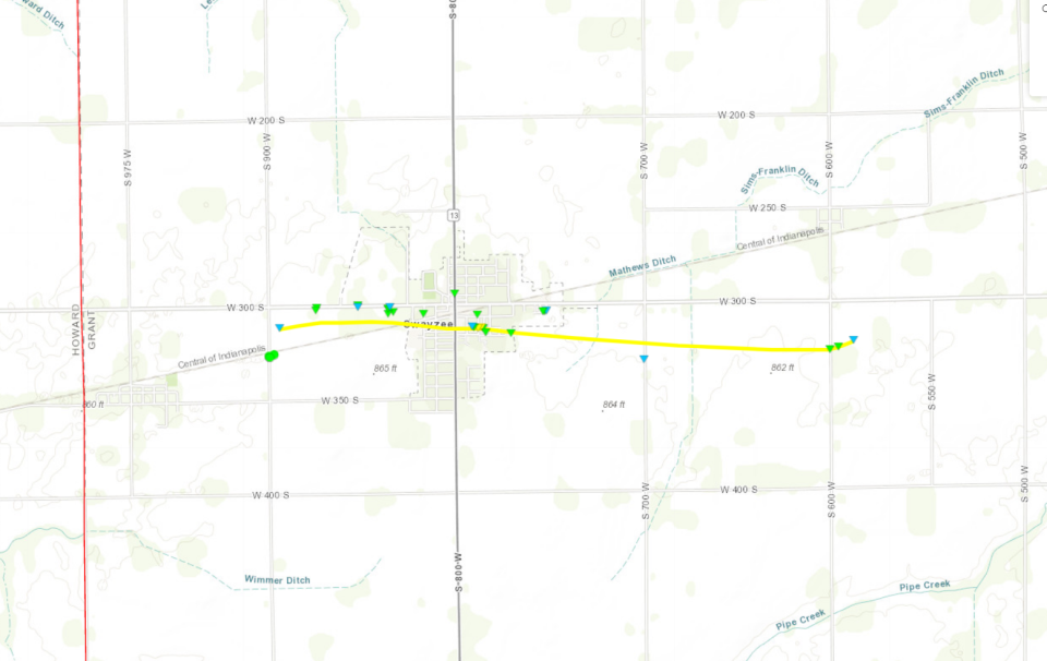
Time: 11:33-11:38 a.m.
EF rating: EF-2
Peak winds: 120 mph
Path length: 3.1 miles
Max width: 150 yards
Injuries/deaths: 0/0
Summary: Several homes and buildings sustained minor to moderate damage, including roof damage to several businesses and a school. Trees and power poles were snapped or uprooted.
Gas City in Grant County
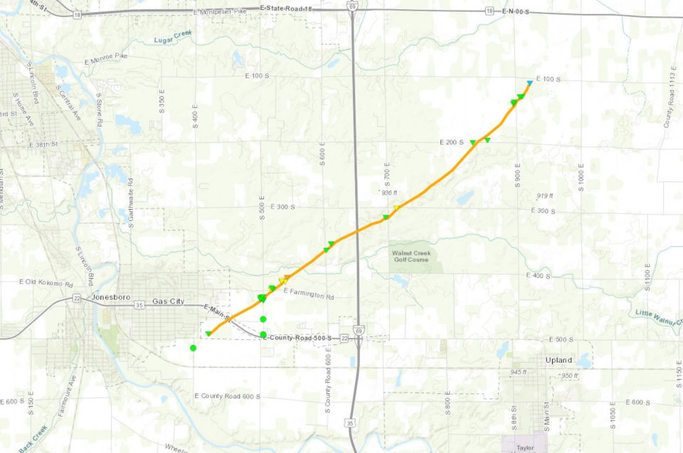
Time: 11:42-11:47 a.m.
EF rating: EF-3
Peak winds: 140 mph
Path length: 6.35 miles
Max width: 200 yards
Injuries/deaths: 0/0
Summary: Homes sustained minor to moderate damage, with extensive tree damage noted in many areas. An area off Blackthorn Drive was hardest hit, with several homes destroyed.
New Haven in Allen County
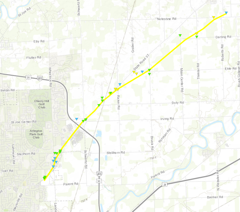
Time: 11:36 p.m. to 11:43 p.m.
EF rating: EF-2
Peak winds: 120 mph
Path length: 7.86 miles
Max width: 400 yards
Deaths/injuries: 0/0
Summary: The tornado developed over the northeast side of Fort Wayne near the intersection of Maysville Road and Cardinal Lane. It quickly raced northeast toward the town of Harlan. Many homes and farms had minor to major damage. Extensive tree damage and powerline damage occurred especially along and south of IN-37 where the most significant damage was observed, especially along Notestine Road. Max width 400 yards and max wind speed estimated to be 120 MPH.
Near Harlan in Allen County
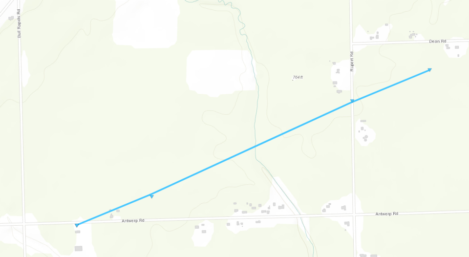
Time: 11:44 p.m. to 11:45 p.m.
EF rating: EF-0
Peak winds: 75 mph
Path length: 1.14 miles
Max width: 75 yards
Deaths/injuries: 0/0
Summary: A brief, weak, and short-lived EF-0 tornado formed in response to a microburst that occurred to the south. The tornado formed just south of Antwerp Road between Bull Rapids Road and Rupert Road. The tornado continued northeast. Debris was observed in adjacent fields north of Antwerp Rd and the survey team also observed some trees snapped in the distance out in the middle of the field. Minor damage was observed to buildings along Antwerp Road and Dean Road. Trees in the vicinity were snapped and uprooted. There was also damage to a home on Rupert Rd near Dean Rd, including roof and siding damage. The tornado dissipated in afield south of Dean Rd. Max width was 75 yards and max wind speed was estimated to be 75 MPH.
Near Salamonia in Jay County
Time: 12:19-12:22 a.m.
EF rating: EF-0
Peak winds: 85 mph
Path length: 1.54 miles
Max width: 175 yards
Injuries/deaths: 0/0
Summary: Debris caused damaged to three barns and moved or partially carried grain bins.
Near Portland in Jay County
Time: 12:20-12:23 a.m.
EF rating: EF-0
Peak winds: 80 mph
Path length: 2.44 miles
Max width: 100 yards
Injuries/deaths: 0/0
Summary: Two barns had wall and roof damage, and trees and power poles were broken.
Contact IndyStar reporter Cheryl V. Jackson at cheryl.jackson@indystar.com or 317-444-6264. Follow her on Twitter:@cherylvjackson.
This article originally appeared on Indianapolis Star: Here's where tornadoes struck in Indiana

