
Hermine lurks off U.S. East Coast, could regain hurricane strength
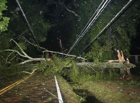
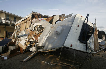
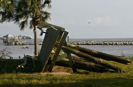
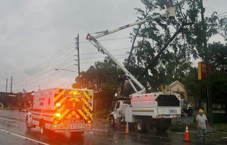


By Daniel Trotta and Chris Prentice NEW YORK (Reuters) - Atlantic storm Hermine lurked off the middle of the U.S. East Coast late on Sunday, threatening to regain hurricane strength but so far sparing the region the brunt of its wind, rain and tidal surge. Forecasters warned the storm could produce deadly surf and ordered swimmers and boaters to stay out of treacherous waters during the Labor Day holiday weekend, when many Americans celebrate the end of summer. Hermine, which came ashore in Florida as a hurricane on Friday, had churned up the southeastern seaboard as a tropical storm before being reclassified on Saturday as a post-tropical cyclone. Robbie Berg of the National Hurricane Center said it was not expected to make landfall again. A tropical storm warning remained in effect Sunday night from the Delaware and New Jersey shores north to New York's Long Island and beyond to Martha's Vineyard and Nantucket Island off Massachusetts. Berg said potential storm-surge inundation levels of no more than 1 to 3 feet (30 cm to 1 meter) were expected in coastal areas. Reflecting the waning storm threat in New Jersey, Governor Chris Christie ordered Island Beach Sate Park reopened for Monday, while warning that lingering rip currents and rough surf might still render the ocean unsafe for swimmers. New York City appeared largely out of harm's way, with forecasters giving Manhattan just a 1-in-3 chance of being hit by tropical storm-force winds as Hermine creeps up the East Coast, Berg said. Hermine's center was located about 370 miles east of Ocean City, Maryland, as of 8 p.m. EDT, according to the hurricane center. It was expected to "meander slowly" off the mid-Atlantic region, remaining at least 300 miles (480 km) from shore, before gradually beginning to weaken by Monday night, then drifting farther east and away from land around mid-week, the agency said. WANING STORM THREAT BEYOND COAST The storm, which claimed at least two lives, in Florida and North Carolina, was still packing maximum sustained surface winds of nearly 70 mph (113 kph) on Sunday night. Forecasters said Hermine could intensify slightly, with winds reaching hurricane strength again before Hermine starts to diminish. But for now its strongest winds were extending outward by about 230 miles, failing to reach U.S. shores, the NHC said. The widespread power outages and flooding that battered Florida, Georgia and the Carolinas had likewise yet to materialize farther north, where alarming news reports scared tourists away from the beach on Sunday. Those who stayed awoke to sunshine but stronger-than-usual winds and choppy seas. "It was a little overhyped by the media," said Andrew Thulin, assistant general manager of Daddy O Hotel Restaurant in Long Beach Township, New Jersey. "It killed the weekend for everybody down here. I talk to all my other colleagues in our business and everybody was like, 'Are we going to send the Weather Channel a bill?'" Farther south in Cape May, New Jersey, tourists fled during rainstorms on Saturday only to have the weather improve. "The temperature is great. It's beautiful out, the birds are out," said Kathleen Wilkinson, a Philadelphia lawyer with a vacation home in Cape May. "Knowing the storm is 100 miles out at sea is comforting." Officials who were mindful of the devastation caused by Superstorm Sandy in 2012 took every precaution. In other parts of the state people reported coastal roads were flooded and beaches swallowed up by the surging sea. Hermine became the first hurricane to make landfall in Florida in 11 years when it swept ashore on Friday near the Gulf Coast town of St. Marks with winds of 80 mph (129 kph), knocking out power for 300,000 Florida homes and businesses. Within five hours, it was downgraded to a tropical storm but still packed a wallop. It left North Carolina with more power outages, flooding, downed trees and power lines, while rain and tides brought flooding along Virginia's coast. The storm was reclassified on Saturday as a post-tropical cyclone as it merged with a conventional weather front. Hermine produced relatively few showers on land Sunday but was forecast to bring up to 2 inches of rain to southern New England on Monday. Commercial air travel was largely unaffected, with airlines reporting only a handful of flight cancellations. (Additional reporting by Steve Gorman from Los Angeles; Editing by Phil Berlowitz and Bill Trott)
