From high to low, Florida weather temperatures continue roller coaster ride for residents
It's not your imagination and no, you're not getting used to the cold. Florida temperatures have been climbing and we could see much warmer temperatures into the weekend. Some areas could even see record highs.
But don't pack those jackets away yet.
By early next week, another cold front will send temperatures plummeting.
Here's the five-day weather forecast from the Florida Division of Emergency Management, along with an early peek into what's coming next week.
Active weather alerts issued across Florida
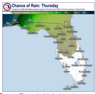
Florida weather forecast for Jan. 24, 25
An area of high pressure along the western Atlantic Ocean will continue to bring warmer temperatures and moisture across the state.
Storms: Scattered to numerous showers can be expected to develop and move northward along the Panhandle and portions of the western Big Bend Wednesday (35-65% chance of rain) and Thursday (50-85% chance of rain). An isolated strong or severe thunderstorm or two could drift into the far western Panhandle Wednesday night.
A cold front moving east from the lower Plains could bring isolated thunderstorms to the western Panhandle, especially on Thursday, and then spread into Northeast Florida.
The Storm Prediction Center is predicting a marginal risk (level 1 of 5) for severe weather along the western Panhandle through Panama City as isolated strong to severe thunderstorms could develop throughout the day on Thursday, but mostly during the late evening and overnight hours.
Isolated strong to severe thunderstorms will be capable of producing lightning, damaging wind gusts (45-60 mph) and heavy downpours. An isolated tornado or two cannot be ruled out.
Conditions across the rest of the state are expected to be mostly dry, but a few light showers may be possible during the afternoon along the immediate East Coast Thursday.
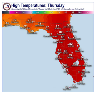
Temperatures: High temperatures on Wednesday and Thursday will be above normal for this time of year, and there is a chance for some record-breaking high temperatures for Tallahassee.
High temperatures in the low to middle 70s can be expected across the Panhandle with elevated cloud cover and rain chances, while the rest of North Florida can expect high temperatures in the upper 70s and near 80 degrees. Across the Peninsula, high temperatures in the low 80s can be expected by the afternoon. Low temperatures will be in the 60s throughout the state, with South Florida and the Keys seeing low temperatures in the low 70s.
Florida weather forecast for Jan. 26, 27
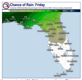
Storms: Expect a cold front to push east across the Panhandle and into Northeast Florida Friday, bringing scattered to numerous showers and isolated thunderstorms. There is a chance for some isolated strong to severe thunderstorms later in evening hours on Friday across the Panhandle.
Stronger thunderstorms Saturday may be capable of producing lightning, damaging wind gusts (45-60 mph) and heavy downpours along the Panhandle. An isolated tornado or two cannot be ruled out.
A second cold front is forecast to move east along the Panhandle and Big Bend Saturday, again bringing changes for rain across Northeast and North Florida Saturday night.
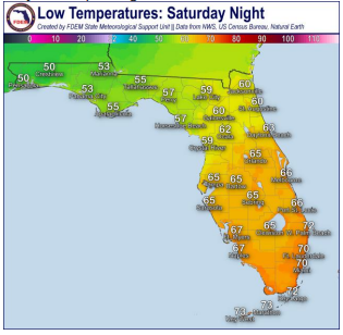
Temperatures: High temperatures on Friday and Saturday will reach the low to middle 70s across the Panhandle and eastern Big Bend, while the western Big Bend and Northeast Florida will reach the upper 70s and low 80s. Central and South Florida can expect high temperatures in the low 80s and approaching the middle 80s.
Record high temperatures may be possible across portions of interior Central Florida later in the week and into the weekend. Low temperatures on Friday will remain above normal for this time of year in the 60s and low 70s.
As the cold front moves through late Saturday, low temperatures across the Panhandle will fall into the low to middle 50s. Ahead of the cold front, low temperatures across Northeast Florida will remain in the low 60s. Central and South Florida can expect low temperatures in the middle to upper 60s, with low temperatures in the low 70s along Southeast Florida and the Keys.
Colder temperatures ahead for Florida during last week of January
Long-range forecasts call for the following temperatures early next week:
Pensacola
Monday: Low 40; high 59
Tuesday: Low 37; high 58
Wednesday: Low 41; high 60
Tallahassee
Monday: Low 44; high 60
Tuesday: Low 38; high 60
Wednesday: Low 39; high 63
Jacksonville
Monday: Low 46; high 61
Tuesday: Low 40; high 60
Wednesday: Low 38; high 61
Daytona Beach
Monday: Low 46; high 58
Tuesday: Low 44; high 61
Wednesday: Low 44; high 61
Melbourne
Monday: Low 48 ; high 61
Tuesday: Low 45; high 65
Wednesday: Low 47; high 66
Port St. Lucie
Monday: Low 49; high 63
Tuesday: Low 46; high 67
Wednesday: Low 47; high 69
West Palm Beach
Monday: Low 50; high 64
Tuesday: Low 47; high 68
Wednesday: Low 50; high 70
Naples
Monday: Low 51; high 64
Tuesday: Low 46; high 65
Wednesday: Low 47; high 68
Fort Myers
Monday: Low 50; high 64
Tuesday: Low 45; high 66
Wednesday: Low 46; high 68
Sarasota
Monday: Low 51; high 61
Tuesday: Low 47; high 63
Wednesday: Low 47; high 66
This article originally appeared on Treasure Coast Newspapers: Florida weather forecast: 5-day outlook record highs, then cold front
