High winds to bring hazardous conditions to El Paso: National Weather Service
Blowing dust could reduce visibility, creating hazardous conditions for drivers in El Paso on Feb. 27.
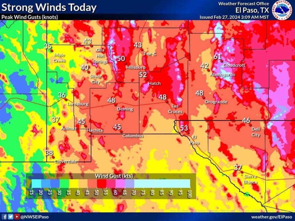
Winds could reach 35 to 45 miles per hour with gusts of up to 70 miles per hour, triggering a high wind warning and wind advisory in the area until 11 p.m., according to the National Weather Service.
Strong winds could also impact drivers, especially those in high-profile vehicles. Visibility could be reduced to between two and four miles, especially from noon to 6 p.m. When driving in dust storms, The National Weather Service advises drivers to slow down, turn on headlights and use the center line of the road as a guide.
Tuesday’s winds may also cause outside property to be damaged; loose objects should be secured.
⚠️Strong Winds and Blowing Dust Expected This Afternoon⚠️
Gusts up to 50-60 mph is likely this afternoon, along with blowing dust reducing visibility along the International Border. Secure outdoor objects and use caution if driving today! #nmwx #txwx #WeatherReady pic.twitter.com/iftrZta4sJ— NWS El Paso (@NWSElPaso) February 27, 2024
Possible rain on Wednesday
El Pasoans will see cloudy skies and cooler temperatures with the chance for afternoon rain in El Paso on Wednesday, Feb. 28.
Roads could become slick overnight, as scattered rain showers and isolated thunderstorms could move into the area, according to the National Weather Service.
Light snow is also possible in the mountain areas in Western New Mexico.
El Pasoans should also begin securing outdoor property; more windy conditions could be on the way this weekend.
Tuesday’s gusts reached a high of 62 miles per hour in the Franklin Mountains and 47 mph at the El Paso International Airport, according to the National Weather Service.
Quite the change tomorrow. Rain chances increase southwest to northeast tomorrow afternoon, peaking during the overnight hours. 0.10-0.25" for the lowlands, with a few locations seeing up to 0.50". 1-3", isolated 5", of snow for the mts, mainly above 7500'. #nmwx #txwx pic.twitter.com/fQeODEL4Wl
— NWS El Paso (@NWSElPaso) February 28, 2024
More: Who's on the ballot? Meet the candidates running in the El Paso 2024 primary election
El Paso International Airport weather status
Info provided by the Federal Aviation Administration's Air Traffic Control System Command Center.
Due to WEATHER / WIND, departure traffic destined for General Edward Lawrence Logan International Airport, Boston, MA (BOS) is currently experiencing delays averaging 1 hour and 3 minutes.
Due to WEATHER / WIND, departure traffic destined for Ronald Reagan Washington National Airport, Washington, DC (DCA) is currently experiencing delays averaging 37 minutes.
Due to WEATHER / WIND, departure traffic destined for Newark International Airport, Newark, NJ (EWR) is currently experiencing delays averaging 1 hour and 8 minutes.
Due to WEATHER / WIND, departure traffic destined for La Guardia Airport, New York, NY (LGA) is currently experiencing delays averaging 27 minutes.
Landfill closes due to high wind conditions
The landfill at 2300 Darrington Road and all Citizen Collection Stations will close at 2 p.m. due to high wind conditions, the city of El Paso posted on X, formerly Twitter.
If weather permits, the landfill and station will resume normal hours, city officials said.
This article originally appeared on El Paso Times: High winds threaten El Paso, hazardous driving conditions expected

