SDDOT reopens I-90 after blizzard-like conditions
Update at 10 a.m. Tuesday: Interstate 90 has been reopened, according to the South Dakota Department of Transportation.
Update as of 8:15 a.m. Tuesday: Parts of I-90 remain closed this morning, following blizzard-like conditions in central South Dakota.
Light precipitation is expected throughout the day, with a winter weather advisory in effect for areas west of the James River.
No time has been given on when the highway may reopen.
Roads in the Sioux Falls area remain slick, but clear, according to sd511.org.
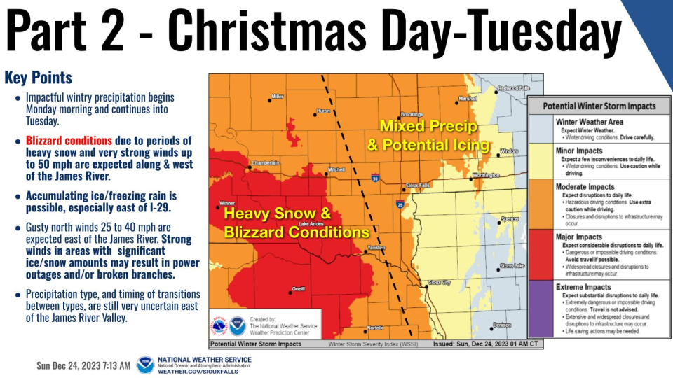
Update at 4:15 p.m. Christmas: The winter storm, affecting much of central South Dakota, has forced the state to close parts of Interstate 90 eastbound and westbound Monday, according to the Department of Transportation.
The system has brought accumulating snow, freezing rain and strong winds, creating blizzard-like conditions and near-zero visibility. The conditions are anticipated through the night, the department stated in a press release.
The closures include:
Interstate 90 (westbound and eastbound) will be closed from Mitchell (exit 332) to Wall (exit 110) at 4:30 p.m. CT/3:30 p.m. MT.
Interstate 90 (eastbound) from Rapid City (exit 67) to Wall (exit 110) is expected to close later at 9 p.m. CT/8 p.m. MT Monday.
Interstate 90 (westbound) from Wall (exit 110) is anticipated to remain open unless weather and road conditions change.
No Travel Advisories (NTA) are also expected to be placed on secondary highways throughout South Dakota due to high winds, icy on roadways, blowing snow, and low visibilities associated with this winter storm system.
"Motorists should not use secondary highways to avoid Interstate closures," the release states. "Significantly reduced visibilities and blizzard-like conditions will make travel very dangerous during this storm system."
Update at 2:45 p.m. Christmas: Areas to the west of Mitchell are now under a not travel advisory, according to the state's road condition tracker at sd511.org.
That includes I-90, between Chamberlain and Mitchell, and Chamberlain and Murdo, according to the tracker. Meanwhile, areas surrounding Sioux Falls are seeing slippery and icey road conditions.
A wintery mix of precipitation is expected to continue until 3 p.m., when precipitation will change to either rain or freezing rain.
"Total daytime ice accumulation of around a 0.1 of an inch possible," the NWS website states. "Total daytime snow accumulation of around 2 inches."
That mix will continue into the evening with a slight chance of rain and freezing rain between 1 and 5 a.m. After 5 a.m., there's a slight chance for rain, snow and sleet, but hardly any accumulation is expected, the NWS website states.
Power outages reported earlier in the day have since been resolved, according to Xcel Energy's website.
Update as of 10 a.m. Christmas: Snow is expected to fall 1 to 2 inches an hour throughout the day as conditions begin to rapidly deteriorate west of Interstate 29, according to the NWS.
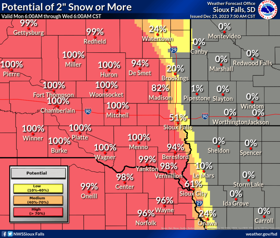
"To put in perspective the forecast challenge today along I-29, the chance for 2" or more of snow in northeast Minnehaha county is about 5%, southwest Minnehaha, 80%," NWS stated on X, formerly known as Twitter.
Here’s a one-minute update on the Christmas Storm. pic.twitter.com/EyIhvBFN8d
— NWS Sioux Falls (@NWSSiouxFalls) December 25, 2023
No power outages have been reported yet for Sioux Falls, but more than 1,100 people are without power to the west, in the Canistota, Bridgewater and Emory areas, according to Xcel Energy's power outage map.
Roads across southeast South Dakota and west are either ice-covered or slippery, according to SD511.org.
Update as of 6 p.m. Christmas Eve: All of Lincoln County and Minnehaha County will be under a winter weather advisory from 6 a.m. Monday to 6 a.m. Tuesday, according to NWS.
Total snow accumulations of 2 to 6 inches and ice accumulations of 1/10 to 2/10 of an inch are expected, the advisory states. Winds gusting as high as 40 mph are possible.
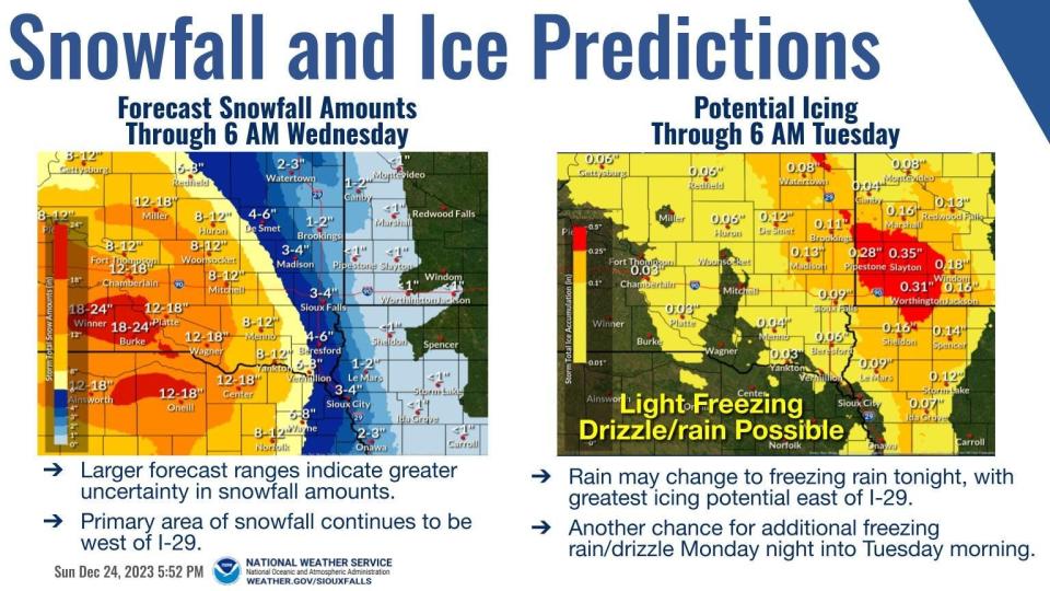
Areas to the west are either under a winter storm warning or blizzard warning, with 8 to 12 inches of snowfall or more expected in some areas, the NWS stated.
Roads out to the west and to the north are already experiencing scattered ice and slippery conditions, according to the state's road condition tracker.
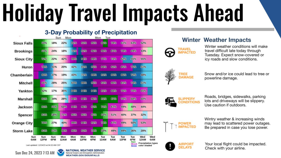
The NWS is urging travelers to avoid getting on the roads if possible. If driving is necessary, remember to slow down, drive with your lights on and pull over if conditions worsen.
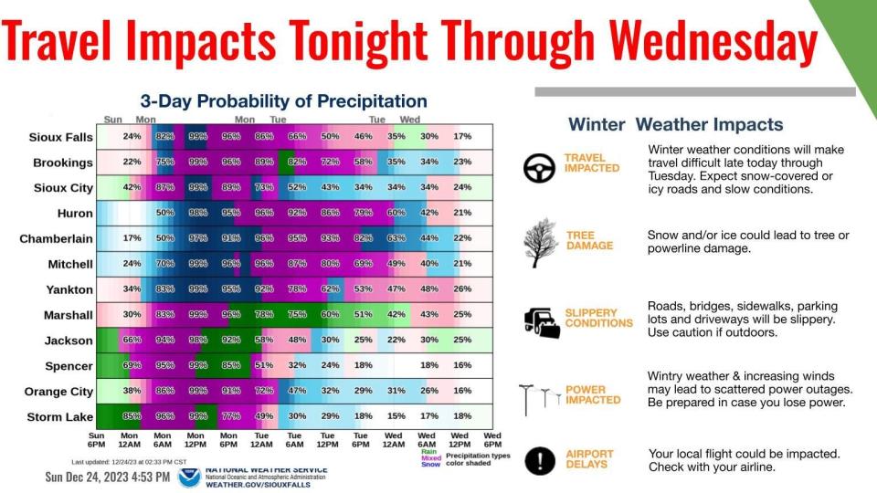
Power outages, tree damage and airport delays may occur.
To check travel conditions near you, visit www.sd511.org.
Update 9:45 a.m. Christmas Eve: Blizzard warnings have been issued in areas west of Sioux Falls, making Christmas Day travel "very difficult to impossible," as this winter system moves through, according to the NWS.
The warnings are for the following areas currently and last from 6 a.m. Monday to 6 a.m. Tuesday:
Beadle
Gregory
Jerauld
Sanborn
Brule
Aurora
Davison
Hanson
Charles Mix
Douglas
Hutchinson
Bon Homme
Yankton
Total accumulations for those areas could be anywhere from 7 to 15 inches of snow, wind gusts up to 50 mph and ice accumulation up to 1/10 of an inch, the warning states.
"Travel could be very difficult to impossible. Areas of blowing snow could reduce visibility to near-zero at times," the warning states. "The hazardous conditions could impact the morning or evening commute into Tuesday. Gusty winds could bring down tree branches."
The highest uncertainty still remains around the Sioux Falls area for how much snowfall will actually accumulate. Right now, the area ishas a 67% chance of seeing 2 inches or more between 6 a.m. Monday and 6 a.m. Tuesday, NWS states. No warnings or watches have been issued for the area at this time.
For the latest on driving conditions, visit sd511.org.
Update as of 9:15 a.m. Saturday: The storm system will come in two phases, according to the NWS.
The first round will be mostly rain, with a light dusting of snow by 6 a.m. Christmas Day. Then round two could bring snowfall that could be 2 inches to 6 inches or more in some areas, affecting holiday travel plans, according to the NWS.
As of Saturday morning, Sioux Falls was expected to see less than an inch of snow by Sunday morning, but there's almost a 60% chance of seeing 2 inches or more by Christmas day into Tuesday, according to the NWS.
Currently, there's a less than 5% chance of there being 6 inches of snow or more for the Sioux Falls area during that same time.
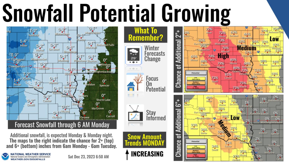
Rain will start transitioning to a wintery mix at about 6 p.m. Sunday for Sioux Falls and then to snow from 6 a.m. to noon Monday, according to NWS. After noon, the precipitation is expected to return to a wintery mix, but much of this is still dependent on temperatures through the holiday. Exact tracking and timing of the system is still evolving, the NWS stated.
For the latest on travel conditions, visit South Dakota 511, or sd511.org.
___________________________________________________________________________________________________________
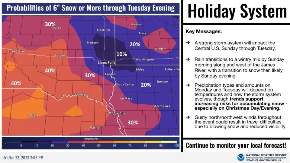
Update as of 7 p.m. Friday: The NWS has given a better idea of when three-days worth of precipitation could start to hit our area.
According to its latest weather briefing from Friday afternoon, Sioux Falls will see mostly rain from 6 p.m. Saturday until after noon Sunday, when the moisture turns to a wintery mix. That wintery mix will linger into Monday until about 6 a.m., when the area could see a transition to snow for the remainder of much of the day, the NWS briefing states.
Snow and rain amounts are expected to be less than an inch through Sunday, but prediction confidence for the amount of snow or rain expected Monday and Tuesday is relatively low, NWS states.
"Precipitation types and amounts on Monday and Tuesday will depend on temperatures and how the storm system evolves. Trends continue to support increasing risks for accumulating snow - especially on Christmas Day/Evening," the briefing states. "Northerly gusts up to 40 MPH will be possible on Monday and Tuesday, which could result in blowing snow and periods of reduced visibility."
The next major update is expected at 5 a.m. Saturday.

Update as of 3:15: p.m. Friday: The National Weather Service of Sioux Falls states precipitation amounts are starting to tick up ahead of the anticipated holiday weekend storm.
"Trends continue to support increasing risks for accumulating snow on Christmas, which coupled with breezy winds could result in difficult travel," the service stated on X, formerly Twitter, on Friday afternoon.
A graphic with the updated showed there was a 10% chance of 6 inches of snow or more through Tuesday in and around Sioux Falls, after the storm arrives in the area late Saturday night. Lincoln County has a 20% chance of seeing that amount, and the further out southwest you go, the higher the precentage is, the graphic shows.
Earlier story: Southeastern South Dakota may see some wintery precipitation this Christmas afterall.
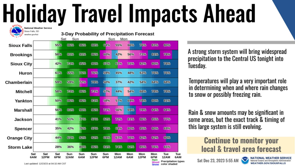
A strong storm system is bringing rain from Sunday to Tuesday to much of the central United States, according to the National Weather Service. And the Sioux Falls area will not be missed.
But exactly how much of that winter precipitation will move in remains unclear. Temperatures will play a key role as the storm system starts to arrive late Saturday, according to the NWS website.
"The system will bring rain, snow and strong winds with it for Christmas time," the website states.

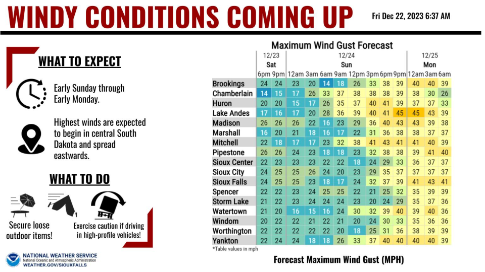
When will high winds hit?
The NWS website states the strongest winds are expected to start in central South Dakota and move eastward early Sunday through early Monday.
"Gusts up to 40-45 mph are expected," the website states. "Gusts will slowly wane through the morning hours on Monday. The strong winds will coincide with falling snow, making for the possibility of minor travel difficulties."
Sioux Falls is expected to see those wind gutsts mostly between midnight and 6 a.m. Monday, which could make Santa's sleigh ride a little bumpy along the way. But conditions won't stop him.
"He does have a lot of magic, so he should be able to weather any type of winds out there," NWS meteorologist Samantha Trellinger said. "He should be able to get to the kids just fine."
In the meantime, residents will want to secure loose items outside, the NWS website states.
When will precipitation arrive, and how much?
Trellinger said the storm system is still too far out to predict how much rain or snow we may have, but the area is expected to see more widespread rain Saturday and Sunday. Then, that rain will transition to snow Sunday afternoon into Christmas Day, she said.
But meteorologists won't have hard numbers on potential snowfall or rainfall amounts until later Friday afternoon or Saturday, she said.
For the latest, refresh this page as updates develop or follow the Argus Leader @argusleader on X, formerly Twitter, as we track the storm through the holiday. Here's a look at the forecast ahead as of 10:30 a.m. Friday, according to the NWS website:
What's ahead?
Tonight: Patchy fog between 11 p.m and 3 a.m. Widespread dense freezing fog after 3 a.m. Otherwise, mostly cloudy, with a low around 30. North northwest wind around 5 mph becoming calm.
Saturday: Patchy fog between 10 a.m and 11a.m. Widespread dense freezing fog, mainly before 7 a.m. Otherwise, partly sunny, with a high near 50. South southeast wind 5 to 15 mph, with gusts as high as 25 mph.
Saturday night: Rain, mainly after midnight. Low around 46. South southeast wind around 15 mph, with gusts as high as 25 mph. Chance of precipitation is 80%.
Sunday: Rain. Temperature falling to around 39 by 5 p.m. Breezy, with a southeast wind 10 to 15 mph becoming north 15 to 20 mph in the afternoon. Winds could gust as high as 30 mph. Chance of precipitation is 100%.
Sunday night: A chance of rain and snow before 9 p.m, then a chance of rain, snow, and freezing rain. Cloudy, with a low around 28. Windy, with a north wind 20 to 30 mph, with gusts as high as 40 mph. Chance of precipitation is 50%.
Christmas Day: A chance of rain, snow, and freezing rain before noon, then rain and snow likely. Mostly cloudy, with a high near 39. Breezy. Chance of precipitation is 60%.
Monday night: Rain and snow. Low around 30. Blustery. Chance of precipitation is 80%.
Tuesday: Rain and snow likely, mainly before noon. Mostly cloudy, with a high near 40. Breezy. Chance of precipitation is 60%.
Tuesday might: A chance of rain and snow before midnight. Mostly cloudy, with a low around 27. Chance of precipitation is 30%.
Wednesday: Partly sunny, with a high near 40.
Wednesday night: Partly cloudy, with a low around 22.
This article originally appeared on Sioux Falls Argus Leader: Sioux Falls Christmas weather: SDDOT reopens I-90 after blizzard-like conditions

