Potential Tropical Cyclone 22 forms following a bout of high winds and rain for Palm Beach County
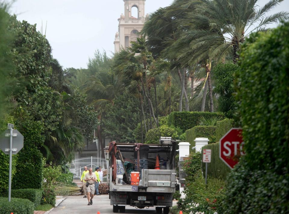
South Florida was battered this week by a robust churn of low pressure that fueled tropical storm-strength wind gusts, doused some areas with as much as a foot of rain and cut electricity to tens of thousands of homes and businesses.
Palm Beach County was spared the brunt of the bad weather Wednesday and Thurday with wind gusts to 56 mph measured in West Palm Beach and rainfall amounts that topped out over a two-day period at 6.19 inches in Delray Beach.
But in Miami-Dade and Broward counties, which were closer to the system that formed over the middle and upper-Keys, one atmospheric scientist said the impacts at his home near Biscayne Park were a “close second” to 2017’s Hurricane Irma.
“Power is off and on, Internet is out, watermain breaks, etc. This was a very significant event,” said University of Miami Senior Research Associate Brian McNoldy in a social media post early Thursday.
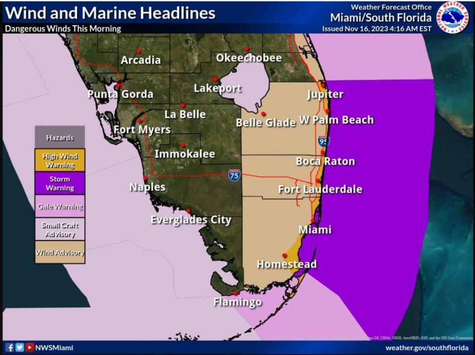
Wind gusts at elevated maritime stations in Miami-Dade County included 75 mph in PortMiami's Government Cut and 73 mph at Port Everglades. Dania Pier in Broward County recorded a gust of 70 mph. Tropical storm-force winds start at a sustained 39 mph. Hurricane-force winds begin at a sustained 74 mph.
Are schools closed in Palm Beach County due to high winds?
Palm Beach County schools remained open Thursday. The Broward County School District closed schools and district offices.
Through noon Thursday, about 21,300 Florida Power and Light customers were without electricity in Palm Beach County. FPL services nearly 783,000 homes and business in the county.
McNoldy called the storm “almost Vince,” referring to the next name on the 2023 hurricane list, and some residents, especially in the Keys, asked on social media why it wasn’t considered a tropical depression or storm.
Well that was interesting #flwx pic.twitter.com/Mt8w5wD1md
— Stu Ostro (@StuOstro) November 16, 2023
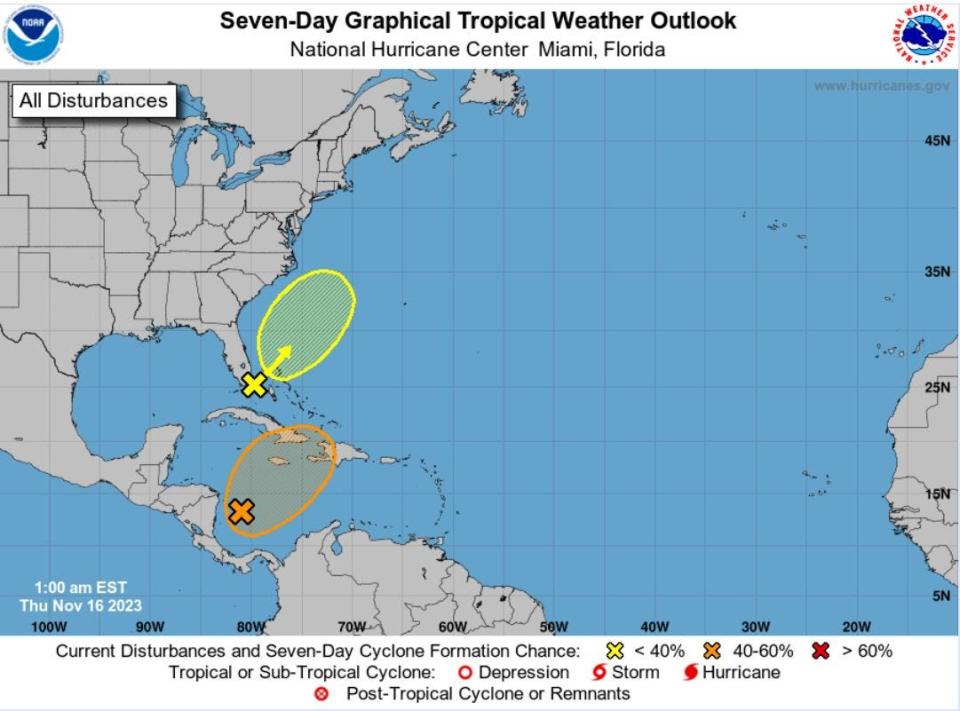
The National Hurricane Center had identified the area of low pressure as having a 10% chance of tropical development.
But while the system’s wind speeds and rainfall resembled the fruits of a tropical cyclone, its physics did not.
Sammy Hadi, a meteorologist with the National Weather Service in Miami, said the system was fueled by temperature differences between warm and cold air along a stalled frontal boundary and a boost from a spat of brisk upper-level winds called a jet streak.
Tropical cyclones form in areas that have weak temperature gradients, powering themselves instead with heat from the ocean.
“This low pressure was connected to a frontal boundary and there was a gradient between warm and cold air,” Hadi said. “It was more like a non-tropical system.”
Regardless of the designation, Hadi said it caused a “wild night across the area.”
In a 48-hour period ending Thursday morning, rain measurements included 13.3 inches in Lauderdale-by-the-Sea in Broward and 10 inches in Miami-Dade's Biscayne Park.
Palm Beach County’s two-day rain totals from the National Weather Service included 6.19 inches in Delray Beach, 4.86 inches in Golden Lakes, 4.74 inches in Boca Raton, 3.63 inches in Greenacres, 3.5 inches in Loxahatchee and 3.36 inches in Jupiter.
The rain totals in Fort Lauderdale added to an already 101 inches that had fallen at Fort Lauderdale/Hollywood International Airport this year. That’s about 46 inches above normal.
Through Wednesday, Palm Beach International Airport in West Palm Beach had measured 68 inches of rain for the year, which is about 11 inches higher than normal.
Hadi said dry air is filtering in behind the area of low pressure, which by mid-day Thursday had moved off the coast. Minor coastal flooding during high tides and spotty showers are possible through Friday.
Friday is forecast to be partly sunny with a high of 83 degrees in West Palm Beach. Saturday should have sunny skies and 81 degrees with an overnight low of 67.
“As we get into the weekend, it looks like a period of relative quiet,” Hadi said. “In general, it will be much better weather-wise."
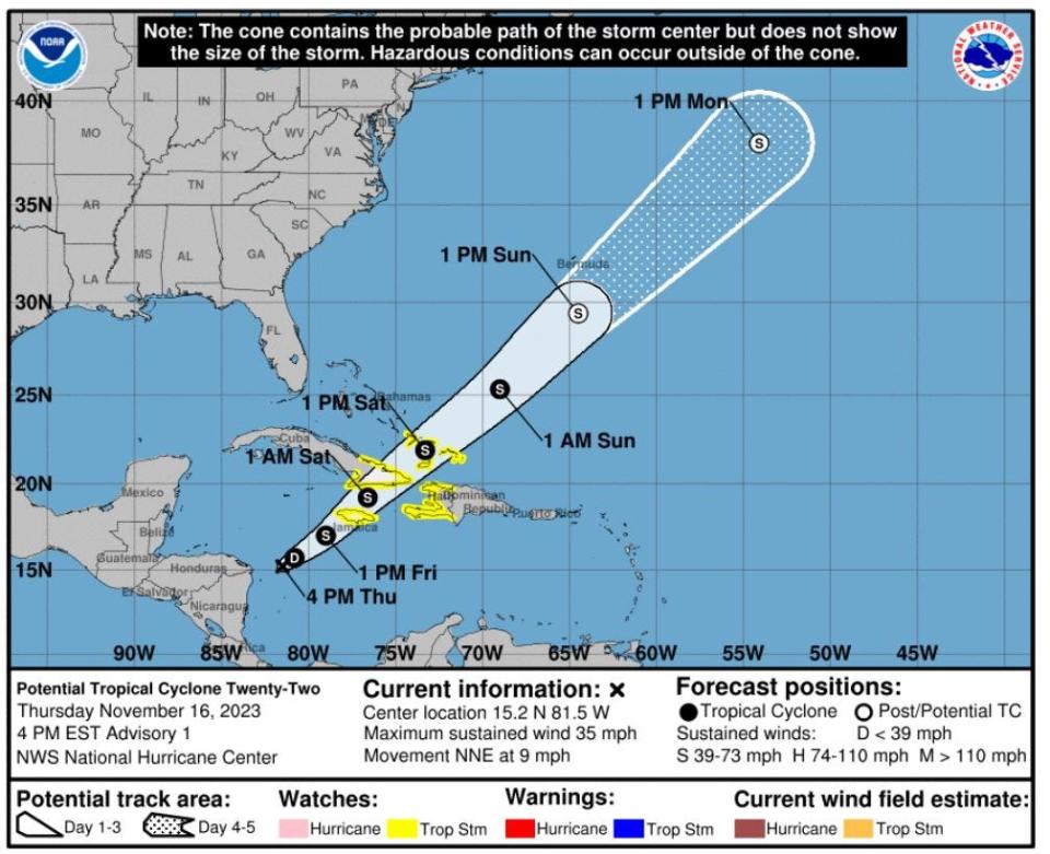
But the tropics isn't quite finished brewing up systems just yet. Late afternoon Thursday, the National Hurricane Center identified Potential Tropical Cyclone 22 about 365 miles west of Kingston, Jamaica. The system is expected to become a tropical storm, but is not forecast to impact Florida.
If it reaches tropical storm strength, it would be named Vince.
Kimberly Miller is a veteran journalist for The Palm Beach Post, part of the USA Today Network of Florida. She covers real estate and how growth affects South Florida's environment. Subscribe to The Dirt for a weekly real estate roundup. If you have news tips, please send them to kmiller@pbpost.com. Help support our local journalism, subscribe toda
This article originally appeared on Palm Beach Post: West Palm Beach weather forecast: High winds; flood watch canceled

