Risk of power outages continue overnight for coastal B.C. due to high winds
Wind warnings are in effect through Boxing Day for parts of British Columbia as a hefty storm rolls into the West Coast.
Gusty winds could easily exceed 100 km/h in spots, leading to the likelihood of power outages during the holiday on Monday.
Across the South Coast, winds near Comox and Victoria may gust close to 90 km/h, as higher resolution models suggest.
Some locations could also see an extended period with over 80 km/h wind gusts.
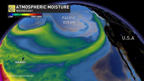
The storm will also draw an atmospheric river into the coast, allowing periods of heavy rain to wash over the region through the middle of the week.
DON’T MISS: Experts confirm huge B.C. blaze spawned a fire-generated tornado
Environment and Climate Change Canada (ECCC) issued wind warnings for northern Vancouver Island, Haida Gwaii, and portions of the Central and North Coast ahead of Monday’s storm.
“Loose objects may be tossed by the wind and cause injury or damage,” ECCC said in its warning. “High winds may result in power outages and fallen tree branches.”
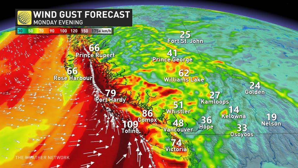
We could see winds gusting up to 80 km/h across Metro Vancouver, peaking Monday evening and continuing into the overnight hours.
Ensure you have emergency supplies like physical flashlights ready in case the power goes out. Avoid driving during the worst conditions if possible. Take note of large trees or tree limbs that loom over your home, staying away from those areas during the highest winds. Trees falling into homes and vehicles are the largest cause of injury in a windstorm.
A surge of subtropical moisture will follow this system inland, fuelling heavy rains and soaring freezing levels across the region.
STORM PREP: Staying safe during a power outage
Vancouver Island and Greater Victoria
Although it will be windy all Christmas Day across Greater Victoria, the winds will peak Monday evening especially for eastern sections of Greater Victoria, including Oak Bay, Mount Douglas, and Sidney, where regions highlighted in red will likely gust close to 90 km/h.
Further up Vancouver Island, very strong winds are forecast for the Comox Valley and western Vancouver Island, where wind gusts will top out at 90 km/h, or even locally higher across western Vancouver Island. Nanaimo is more protected, so wind gusts will be below 60 km/h for Nanaimo, Ladysmith, and Duncan.
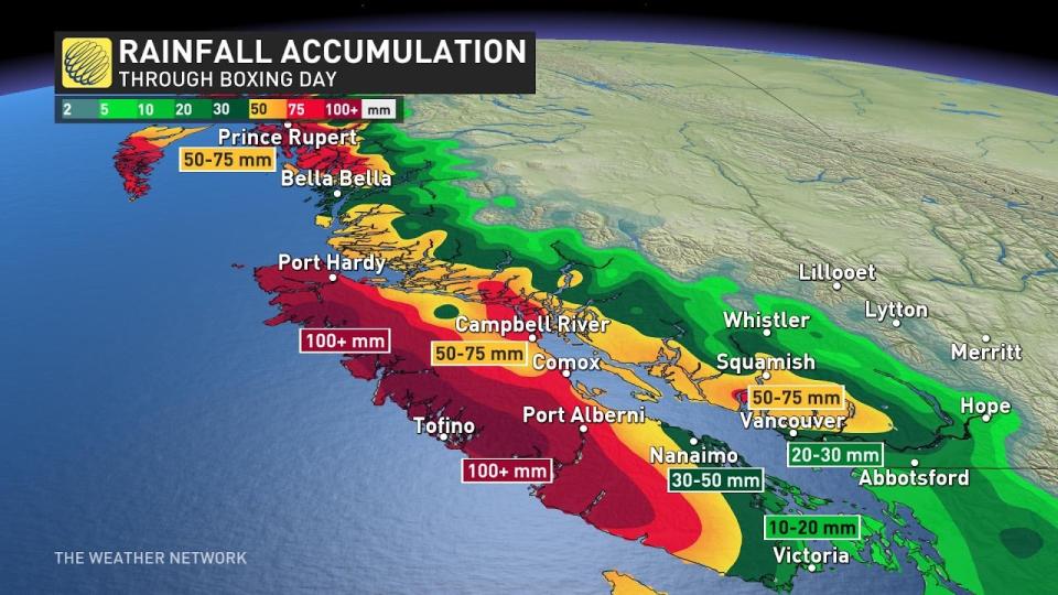
The Island will take the brunt of the rainfall. We could easily see more than 100 mm of rain through Boxing Day across the western shores, where terrain enhances rainfall rates.
Totals of 50-75 mm are possible up toward Comox and Campbell River, while Metro Victoria will fall in its usual rain shadow with totals around 10-20 mm.
WATCH: Vancouver Island coast to end Christmas Day with damaging winds
Lower Mainland
As the frontal system crosses the Lower Mainland, intense southerly winds are forecast to sweep across sections of the Lower Mainland.
Particular locations near the beaches and south of the Fraser River have the highest likelihood of gusts over 80 km/h, so be prepared for some power outages.
Rainfall totals will range from 30 to 75 mm across the Lower Mainland, with the highest totals expected around Metro Vancouver.
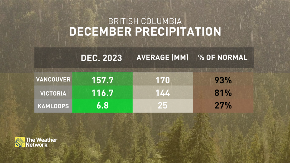
This rain is a big deal for Vancouver proper, where we’re on the cusp of December’s rainfall tipping into above-average territory.
An average December measures about 170 mm of rain. We’ve seen 157.7 mm at the airport so far this month. If the forecast trends hold, this will only be the second month in 2023 Vancouver managed to see above-average precipitation.
MUST SEE: How to prevent food from getting spoiled during a power outage
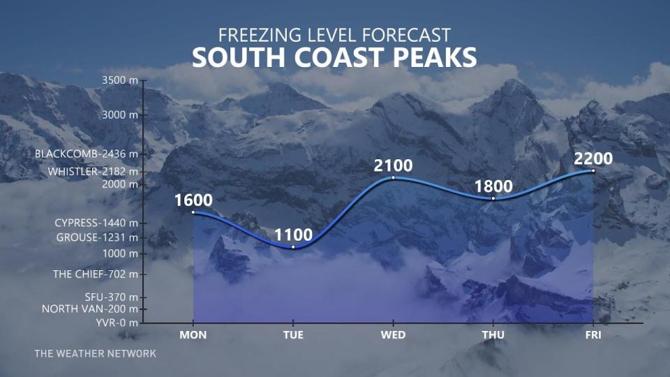
The arrival of subtropical moisture means that freezing levels will rise on Christmas Day. We’ll see the freezing level jump to around 1600 m over the Lower Mainland before sinking back a bit for Boxing Day on Tuesday.
Another moisture-laden system is likely to arrive on the West Coast by Wednesday, bringing additional rainfall and freezing levels as high as 2200 m, which is bad news for ski resorts looking for relief heading into the beginning of 2024.
Thumbnail courtesy of Ryan Voutilainen via X.
Stay with The Weather Network for the latest on your forecast across British Columbia.

