Hike along the Narrow River at former Girl Scout camp in North Kingstown: Walking RI
NORTH KINGSTOWN — A few flat fieldstones and short railroad ties form a set of steps that lead to a thin, sandy beach where thousands of Girl Scouts once beat the heat with a cool dip in the Narrow River.
That short, deteriorating stairway is about all that’s left of Camp Narrow River.
The summer camp opened in 1988 and closed around 2006. The Girl Scouts of Southeastern New England sold the property in 2015 to the Nature Conservancy, which now manages the area, called King Preserve, that includes a network of interconnected trails.
The paths in the 161-acre sanctuary cross footbridges over wetlands and streams, pass through a tunnel of spruce trees and run along the banks of the river where the girls once swam.
Walking RI: Drought bares hiking trails often under water near Brushy Brook in Exeter
Walking RI: Hike the 'Big Hill' in Cumberland, where skiing was once a favorite winter pastime in RI
Who is King Preserve named for?
The King Preserve is named for Dave King (1928-2014), the first executive director of the Champlin Foundation, which helped finance the Nature Conservancy’s purchase.
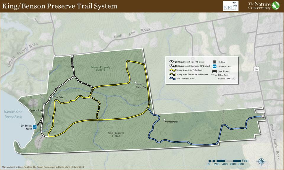
I set out to explore the Scout camp, which previously had been farmland, after studying a color-coded trail map at a trailhead kiosk off Boston Neck Road.
The blue-blazed path, named Julia’s Trail for King’s dog that accompanied him on his walks, started out flat and headed west under a hardwood forest of oaks and maples. Thick roots crossed the dirt path at times as it began a long, gradual descent toward the river.
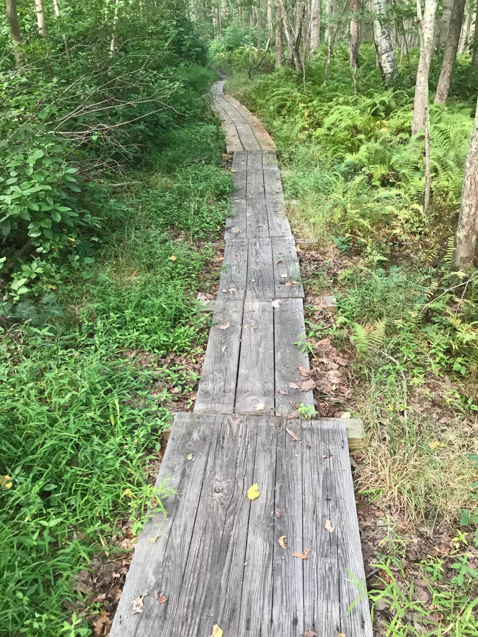
At a turn, a side spur headed south toward Casey’s Farm, but I stayed on the blue-blazed trail as it crossed a series of wooden bog bridges over lowlands, which in late August were bone-dry from the summer’s severe drought. A depression in the land just off the trail looked like a dry vernal pool that hopefully will fill with water and new life in the spring.
Walking RI: Discover a hidden gem of forest, ponds and wetlands in Little Compton
Walking RI: Spectacular bay views and Colonial and tribal history at Mount Hope Farm
When I came to a T-intersection, I went left on the yellow-blazed trail and walked along what looked like a raised berm for a cart path before getting my first glimpse of the river through the trees.
At the end of the yellow-blazed path, with the river straight ahead, I turned left onto a road and passed several clearings that once had tent platforms for the Scout camp. The Nature Conservancy staff removed the platforms to deter camping and used the wood for some of the bog bridges on the trails.
The road ended at a stone wall with a sign marking private property. I respected that and retraced my steps, passed the yellow-blazed trail on the right and followed the road over a gravel and dirt embankment. A 4-foot-wide culvert built by the Girl Scouts ran through the base of the berm. It was constructed to carry water from an unnamed brook to the river without washing out to the road.
Walking RI: Discover why hikers and anglers love the 'wild and scenic' Beaver River
Walking RI: Want to practice some rock climbing? Head to Connors Farm in Smithfield
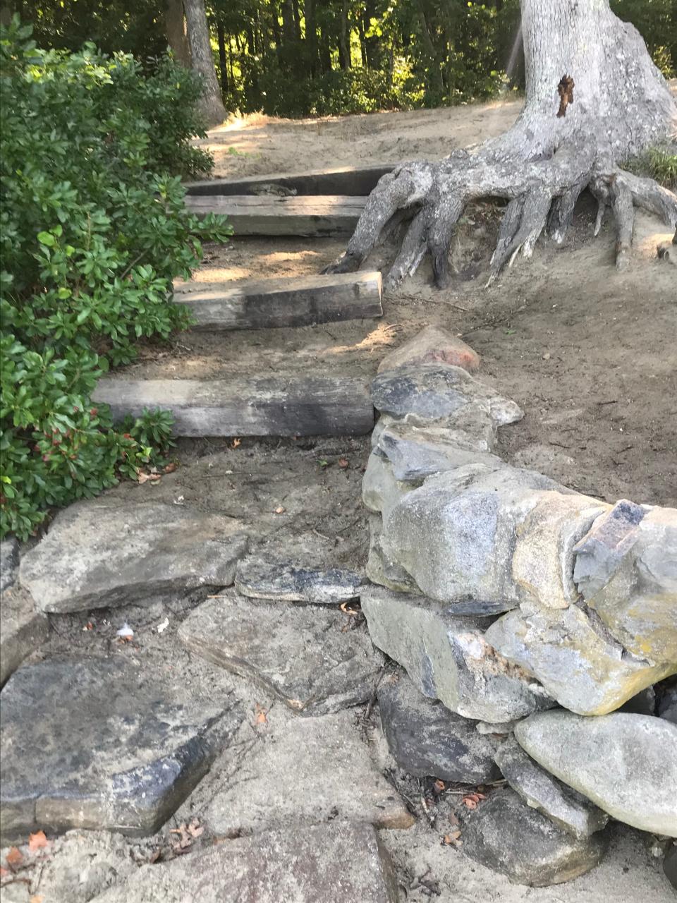
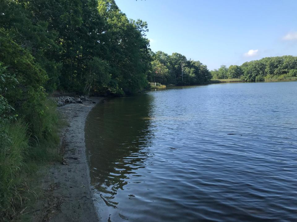
After studying the construction, I returned to the road and, a short distance later, took a side spur on the left that ran down to the river. That’s where I found a set of short railroad ties on the riverbank just above the stone steps leading to the beach. There also was a low stone wall built to stabilize the bank and perhaps stop the river from washing away the beach.
The Girl Scouts who swam here had a gorgeous view of the tree-lined shore across the upper basin of the Narrow River. To the south, a cove is covered with tall reeds, eel grass and cattails. Dozens of paw prints on the beach indicated that it’s a popular destination for dog walkers.
The quiet shoreline, with a soft breeze blowing in my face from the west, was disturbed by the occasional sound of a car engine on Route 1 across the water.
Walking RI: Leave the noise behind at a wooded retreat in Richmond
Walking RI: Follow in the footsteps of Trappist monks in Cumberland
Narrow River is actually a tidal estuary, where freshwater and saltwater mingle
The Narrow River is also known as the Pettaquamscutt River, a Native American term that could mean round rock, place near round rock or place that goes into cool water. The river is actually a fjord-like tidal estuary that narrows and widens in several places for about seven miles as it runs from Gilbert Stuart Stream to the ocean.
Tides push the saltwater up the river as far as the dam at the Gilbert Stuart Museum and it mixes with freshwater from Gilbert Stuart Stream and other inland sources.
I tasted the brackish water, which supports remnant wild oysters.
The estuary is an important stopover in the spring for long-distance migrant birds looking for food, water and shelter in the surrounding woods. A hiker I met on the beach told me an eagle sometimes soars over the area. And ospreys dive for herrings that run in the river in the spring.
Walking RI: Tillinghast Pond's trails are part of something special and well worth a visit
Walking RI: Mingle with birds, beavers, mink and more at Exeter's Fisherville Brook refuge
Part of an environmental buffer from nearby developments
The King Preserve, Casey Farm and Benson Preserve to the north create a 700-acre contiguous buffer against adjacent development by absorbing nutrients and other pollutants that might be carried into the estuary by stormwater runoff.
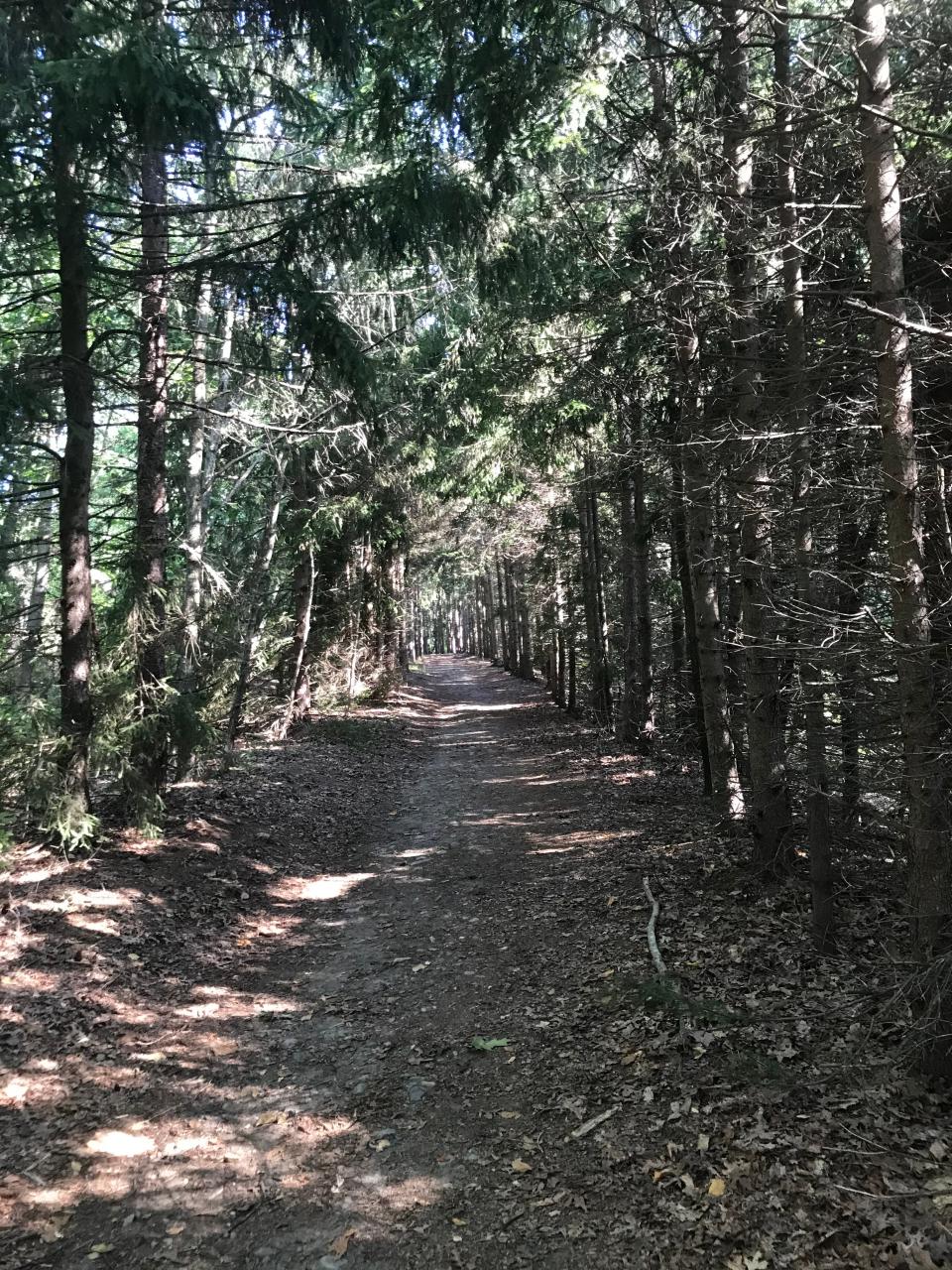
After resting for a few minutes, I continued north on the white-blazed trail that ran parallel to the river and through a long tunnel of towering Norwegian spruce trees. I reached a gate and markings for private property with a field and a cabin on the left that overlooks the river and may have once been a Girl Scout lodge.
Retracing my steps, I took a left on the Pettaquamscutt Trail, which wound north through heavy brush and over bridges before reaching a sitting bench below a series of stones that form a streambed and waterfall in wet weather.
There’s also a sign for Alison Wong Noto, a Nature Conservancy supporter who died in 2018.
Walking RI: Family-friendly hiking at a former Girl Scout camp in Westerly
Walking RI: Looking for a great birdwatching spot? Try this former Navy site in North Kingstown
I continued on the path into the Benson Preserve, a 43-acre property purchased from the estate of Elsie Benson and managed by the Narrow River Land Trust.. After reaching a trailhead on Snuff Mill Road, I turned, retraced my steps, found the yellow-blazed trail and took it southwest. Just as I got another peek at the river again, the trail turned east and then north on a connector path through dry uplands. The stone walls marked land that was once cleared for a pasture.
I turned east on the yellow-blazed trail, then north on a connector trail and then east again before stopping to inspect a set of high stone walls that created enclosures. The map named the area the Hazard Sheep Pens, perhaps for the family of Irving and Thelma Hazard, who once owned nearby land.
Walking RI: A step-by-step guide to beautiful Stepstone Falls
Walking RI: Best place for a hike and osprey spotting? Try the Great Swamp in South Kingstown
The trail eventually joined the blue-blazed path that I had walked in on. I took it east and returned to where I'd parked. Overall, I walked 4.5 miles over about 2¼ hours.
Any of the loop trails in the King Preserve makes for a good walk of any length you choose. But make sure you don’t miss the Girl Scout Beach on the Narrow River. It’s a nice place to stop, rest, enjoy the view and think a bit about the history.
Trail Tip
With the start of hunting season on Sept. 15, all users of state management areas and most preserves are required to wear 200-square inches of fluorescent orange.

John Kostrzewa, a former assistant managing editor/business at The Providence Journal, welcomes email at johnekostrzewa@gmail.com.
.
This article originally appeared on The Providence Journal: Hike along the Narrow River at King Preserve: Walking RI

