Hike the 'Big Hill' in Cumberland, where skiing was once a favorite winter pastime in RI
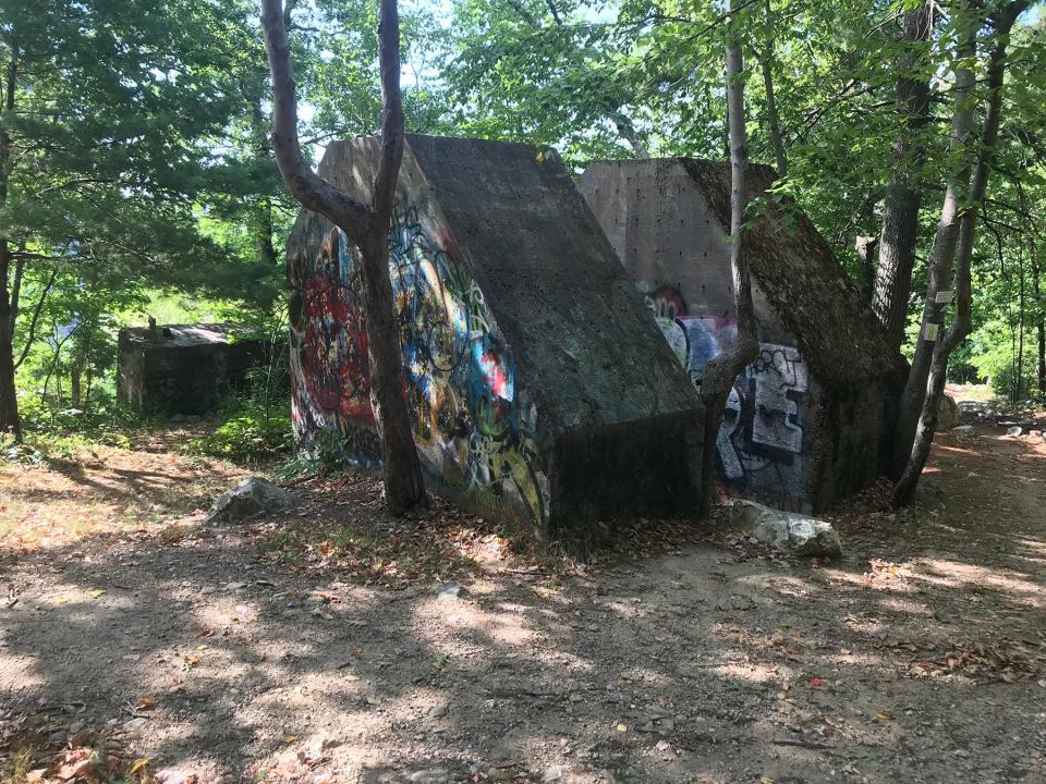
CUMBERLAND — Two giant concrete blocks, spray-painted with colorful graffiti, may seem out of place now on the wooded summit of Diamond Hill. But they once anchored the lifts that carried skiers to the top of what locals call “The Big Hill.”
The ski area’s rope tows, chair lifts and T-bars have been gone for decades, though, as have most of the other remains of the once-popular recreation area.
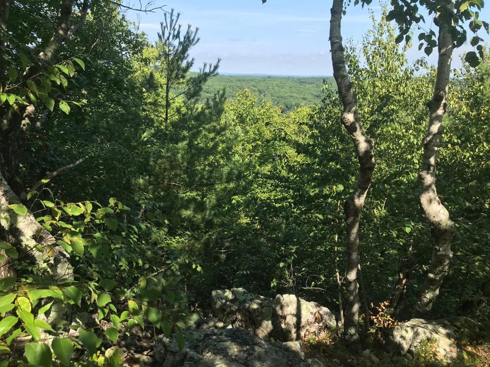
But standing on the high cliffs near the anchors, it’s not hard to imagine thousands of Rhode Islanders gliding down the slopes and enjoying some winter fun.
The 481-foot Diamond Hill actually had two ski areas.
Walking RI: Discover a hidden gem of forest, ponds and wetlands in Little Compton
Walking RI: Spectacular bay views and Colonial and tribal history at Mount Hope Farm
On the eastern slope, Ski Valley attracted enthusiasts with a toboggan chute and several skiing trails. After it closed, the area was developed with condominiums.
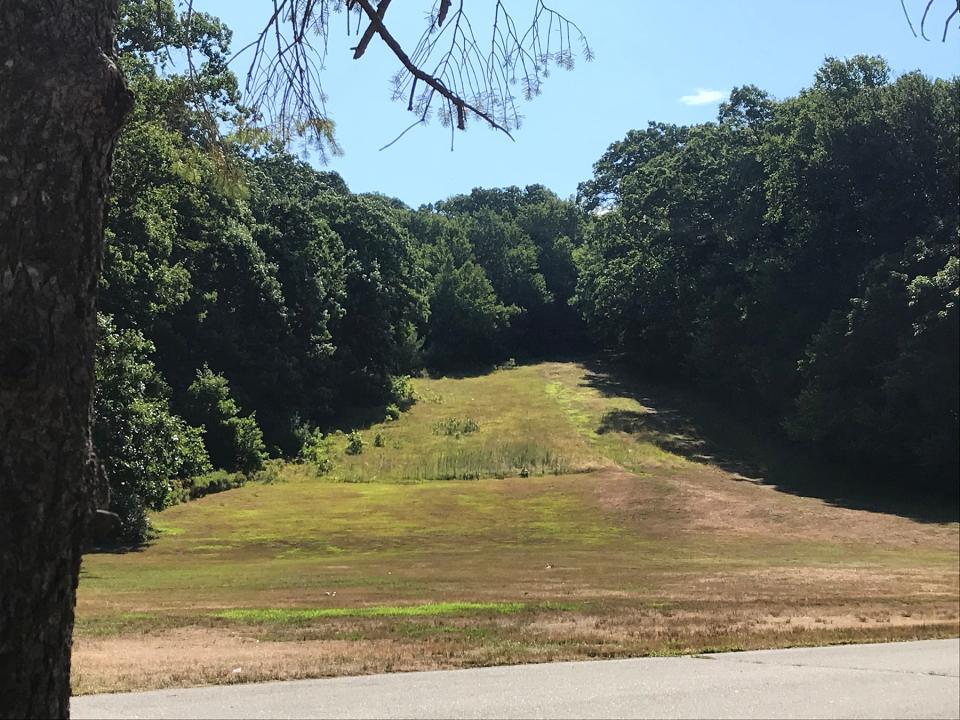
On the northwestern slope of Diamond Hill, skiers could pick from one of several runs cut through thick trees to ski down a 350-foot vertical decline. The land is now a town park with miles of hiking trails up and down the hillside and a grassy field at the bottom where the town’s annual CumberlandFest carnival and fair is held in August.
What's the easiest route to climb the hill?
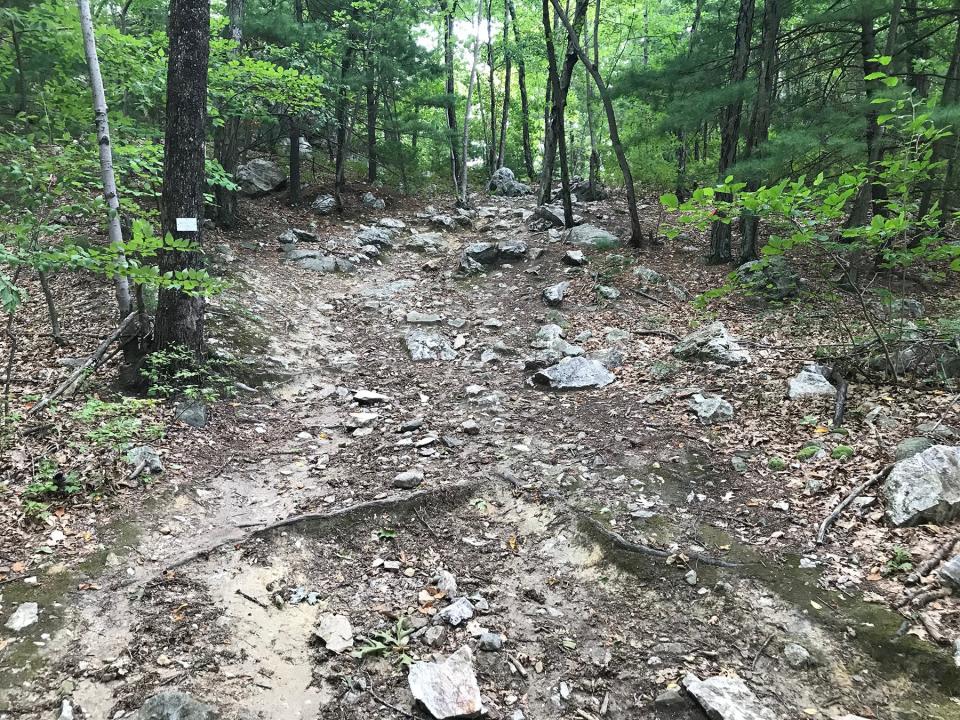
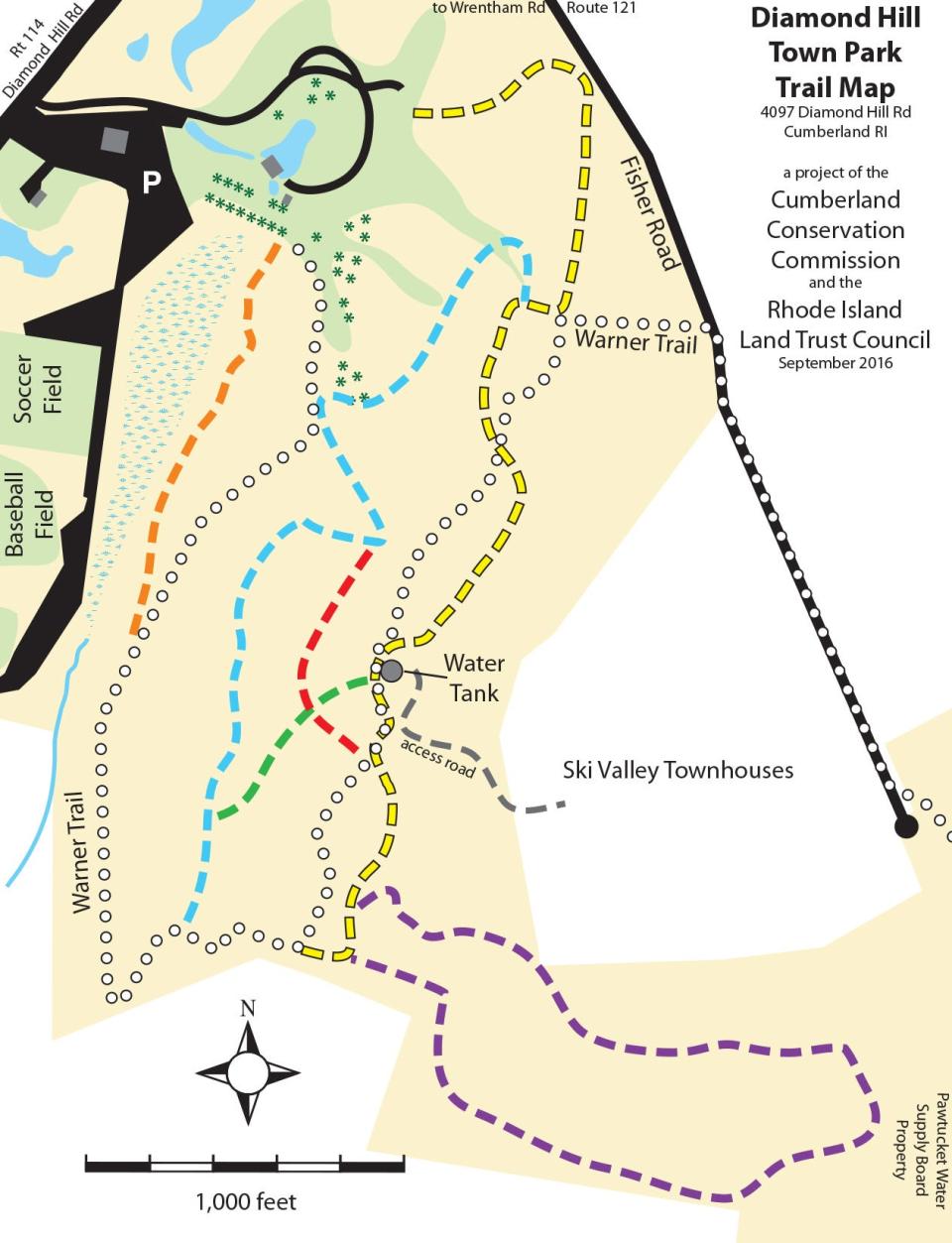
I set out to find what’s left of the old ski areas from the parking lot off Diamond Hill Road. I stopped at a kiosk and took a cellphone picture of a map of the color-coded trails, because I had read that the maze of paths can be confusing. I decided to walk a perimeter route rather than climb straight up the hill.
Walking RI: Discover why hikers and anglers love the 'wild and scenic' Beaver River
Walking RI: Want to practice some rock climbing? Head to Connors Farm in Smithfield
Following a line of trees, I walked east and part way up a grassy slope that was once the end of a ski run. On the right, I spotted a white marker for the Warner Trail, which took me under pine trees. The gravel path cut across the hillside, and I noticed some silver discs nailed high on some trees that must have been earlier trail markers.
The path passed a rusty chain-link fence before turning south. On the right and at the bottom of the hill is an old railroad bed that runs along Sylvys Brook, which flows south from Miscoe Lake, past Diamond Hill and eventually into Ash Swamp Brook and then Arnold Mills Reservoir. The brook is named for a daughter of John Whipple’s family who lived near Diamond Hill in the 1830s.
The trail crossed over a rusty water pipe that may have once carried water from the brook up the hillside to snow-making machines.
Walking RI: Leave the noise behind at a wooded retreat in Richmond
More: Follow in the footsteps of Trappist monks in Cumberland
To the left of the trail was a steep, rocky hillside with several side paths that led to the top of Diamond Hill. But I stayed on the trail marked with white arrows as it veered sharply to the left and continued part way up the hill on what looked like an old road.
At a junction, a purple-blazed trail opened on the right and I took the loop downhill through shrubs and under trees. The path passed by the backyards of several houses before turning back uphill and returning after about three-quarters of a mile to the white-blazed trail.
Walking RI: Tillinghast Pond's trails are part of something special and well worth a visit
Walking RI: 5 great hikes with ocean views
How Diamond Hill got its name
I followed it up an incline, passing massive outcroppings and fields of rocks with veins of white quartz and mica that glistened in the sun. Early Colonial settlers spotted the sparkling stone ledges and gave Diamond Hill its name.
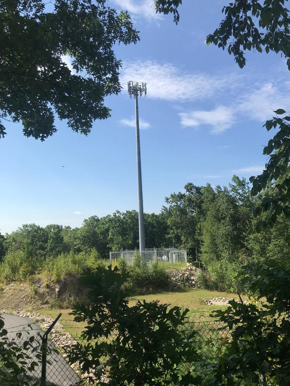
After a short distance, the trail flattened and came to an 80-foot gray communications tower protected by a high chain-link fence topped with barbed wire. Next to the tower was a round water tank that services townhouses to the east.
Walking RI: Trolley line left its mark at Lincoln's Lime Rock Preserve
Walking RI: Mingle with birds, beavers, mink and more at Exeter's Fisherville Brook refuge
Hikers report that on crystal-clear days, you can look northeast and see Mount Wachusett and the Boston skyline. But I couldn’t see much through the trees.
Just behind the water tower, on the high point of the land, are several sets of concrete anchors for the ski lifts. There also was a short path west to the edge of a cliff where smaller concrete blocks are located, which must have carried the cable up the hill and then to the anchors. I rested on a sitting bench, drank some water and thought about the area’s history.
Walking RI: The haunting legacy of Tiverton's Fort Barton Woods
Walking RI: Ninigret National Wildlife Refuge harbors naval, tribal history
The Diamond Hill Granite Company opened a quarry, where they mined granite and copper just northwest of the hill, starting in 1877. After a series of owners, Philip Allen, C. Faulkner Kendall and Henry Munroe Rogers donated about 235 acres on and around the hill to the state in 1935.
Ski runs, trails built by Depression-era Civilian Conservation Corps
The first ski runs, toboggan slides, cross-country trails, sledding routes and ski jump were built in 1936 and 1937 by the Civilian Conservation Corps, the federal program set up by President Franklin Roosevelt to provide jobs to unemployed young men and veterans during the Depression. The workers from the CCC’s Primrose Camp also built roads and a pavilion and blocked part of Sylvys Brook to create a stone-lined pond for skating and fishing.
Walking RI: Family-friendly hiking at a former Girl Scout camp in Westerly
Walking RI: Looking for a great birdwatching spot? Try this former Navy site in North Kingstown
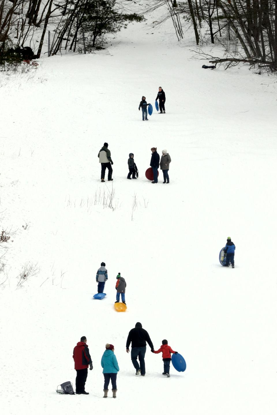
When the Diamond Hill Ski Area opened on a Sunday afternoon in January 1938, a huge crowd of about 17,400 jammed the roads and covered the hillside to watch members of local ski clubs compete in ski jumping, cross-country, slalom and downhill events. There were also demonstrations on how to ski, which many people tried for the first time.
Back then, a rope tow was the only way to reach the top of Diamond Hill. When Ski Valley first opened, skiers at first had to hike up the hill to ski down.
In the mid-1960s, the state leased Diamond Hill and Ski Valley to private operators, including members of the Egan family. They installed a T-bar and later the double chair lifts and the conc anchors I found. New trails were cut and snowmaking was expanded.
Walking RI: Best place for a hike and osprey spotting? Try the Great Swamp in South Kingstown
Walking RI: A step-by-step guide to beautiful Stepstone Falls
Diamond Hill, just 14 miles from Providence, became a popular spot for couples on their first date and novices learning to ski. Children enjoyed a cup of hot chocolate in the warming hut and teenagers did some night skiing after school.
Changing habits, snowless winters: The decline of Diamond Hill's ski areas
But by the mid-1970s, some of the ski areas were losing money, and some of the lifts and equipment were sold to operators at Mount Watatic in Massachusetts and Temple Mountain in New Hampshire.
After a few more tough years, Diamond Hill closed in 1982. Ski Valley lasted until 1985.
During a hike earlier this year in Exeter to Pine Top, another local ski area, I learned that skiing boomed in New England in the 1960s and that several small venues in Rhode Island were big hits, including Yawgoog Valley in Exeter, Diamond Hill in Cumberland, Ski Valley in Cumberland, and Neutaconkanut Hill in Providence.
Walking RI: Nature reclaims former ski site Pine Top in West Greenwich
Walking RI: Retracing Thoreau's 1854 hike through Providence
Walking RI: Rediscover Providence's Roger Williams Park on a serene hike around its ponds
Rhode Islanders liked the beginners’ slopes to learn to ski, the short drive to inexpensive outdoor recreation (an all-day, adult lift ticket cost $3.50 in the 1960s at Diamond Hill) and the places to hang out and have a good time.
But the areas’ popularity faded in the 1970s, when an energy crisis made gasoline, if you could find any, expensive, and families faced tough economic times. Also, people’s interests changed, and then there were several bad snow years in a row. Most operators sold off their equipment and closed.
Only Yawgoog remains.
In 1997, Cumberland acquired Diamond Hill from the state and started to develop what’s now a 373-acre town park.
After exploring the summit and finding no other remnants from the ski area, I took the yellow-blazed path north. At one point, the path crossed the white-blazed Warner Trail, which runs east about 30 miles to Sharon, Massachusetts.
Walking RI: Take in the fragile beauty of Warren's Touisset Marsh during a coastal hike
Walking RI: Time-traveling along the Queen River in Exeter
The wide, yellow-blazed path then ran downhill, with Fisher Road visible to the right, until it exited the woods at a huge field that once may have been the end of a ski run. The town park spread out in front of me, including a picnic area, athletic fields, a stone- lined reservoir, fishing pond and band pavilion.
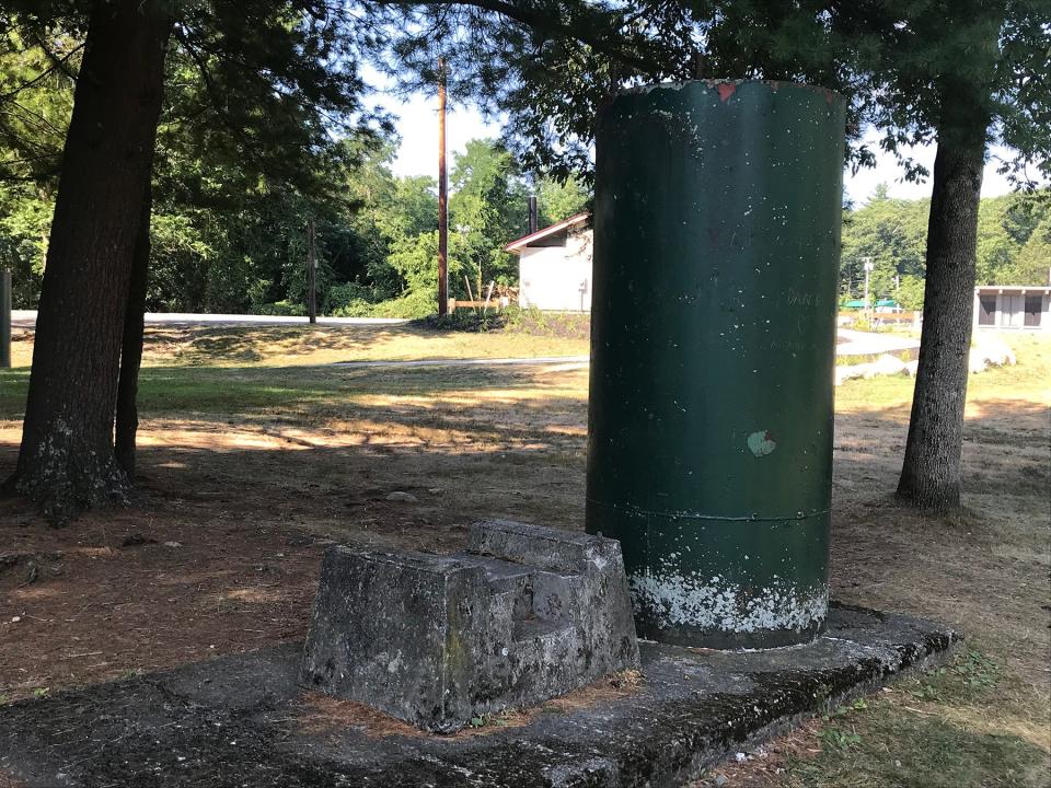
I wandered back through the park and ended up back where I'd started at the kiosk. I discovered I'd missed two large, cylindrical anchors, painted green, on conc bases that must have been used for the base of the lifts. From there, I finished the 3.8-mile hike in about two hours.
Walking RI: At Trustom Pond in South Kingstown, silence is golden
Walking RI: Coastal views and prime bird-watching at Tiverton's Emilie Ruecker preserve
On the way back to the parking lot, I talked for a few minutes with a couple of town workers who were breaking down the seating left from CumberlandFest.
They didn’t know much about the history of the ski area but said they recalled a few of their grandparents’ stories from back in the day, when “The Big Hill” was the place to be on a winter afternoon.
Trail Tip
The Cumberland Conservation Commission has set these guidelines for Diamond Hill:
• Stay on the marked trails.
• Hunting, fishing and collecting are prohibited.
• ATVs and other motorized vehicles are not allowed.
• Respect the private property that abuts the public park.
John Kostrzewa, a former assistant managing editor/business at The Providence Journal, welcomes email at johnekostrzewa@gmail.com.
If you go ...
Access: From Route 295, take Route 114 north for 4 miles to reach the park on the right at 407 Diamond Hill Rd.
Parking: Available in a large lot.
Dogs: Allowed, but must be on a leash.
Difficulty: Moderate on rocky uphill trails.
This article originally appeared on The Providence Journal: Former RI ski site Diamond Hill Park can be a rugged hiking workout

