Hike through unique Ice Age terrain at Dr. John Champlin Glacier Park: Walking RI
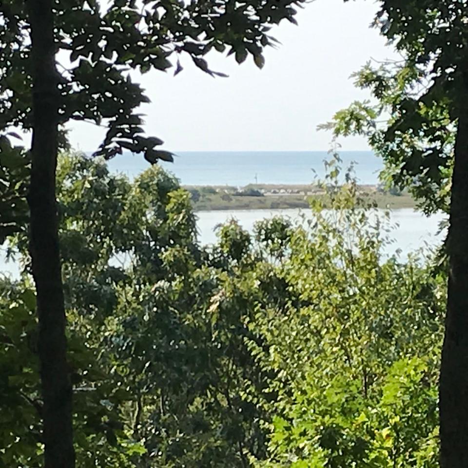
WESTERLY — From Charlie’s Overlook, hikers can peer through the trees to see Winnapaug Pond, the Misquamicut barrier beach, the Atlantic Ocean and — on a crystal-clear day — Block Island.
Named for Charles F. Hickox Jr., the late geologist, outdoorsman and educator, the high point is on a long, rocky ridge, called a moraine, at the southern tip of the Dr. John Champlin Glacier Park. The preserve’s other geologic features include a unique set of kames, kettle ponds and erratics that explain how the land was shaped by massive ice sheets that swept across Rhode Island tens of thousands of years ago.
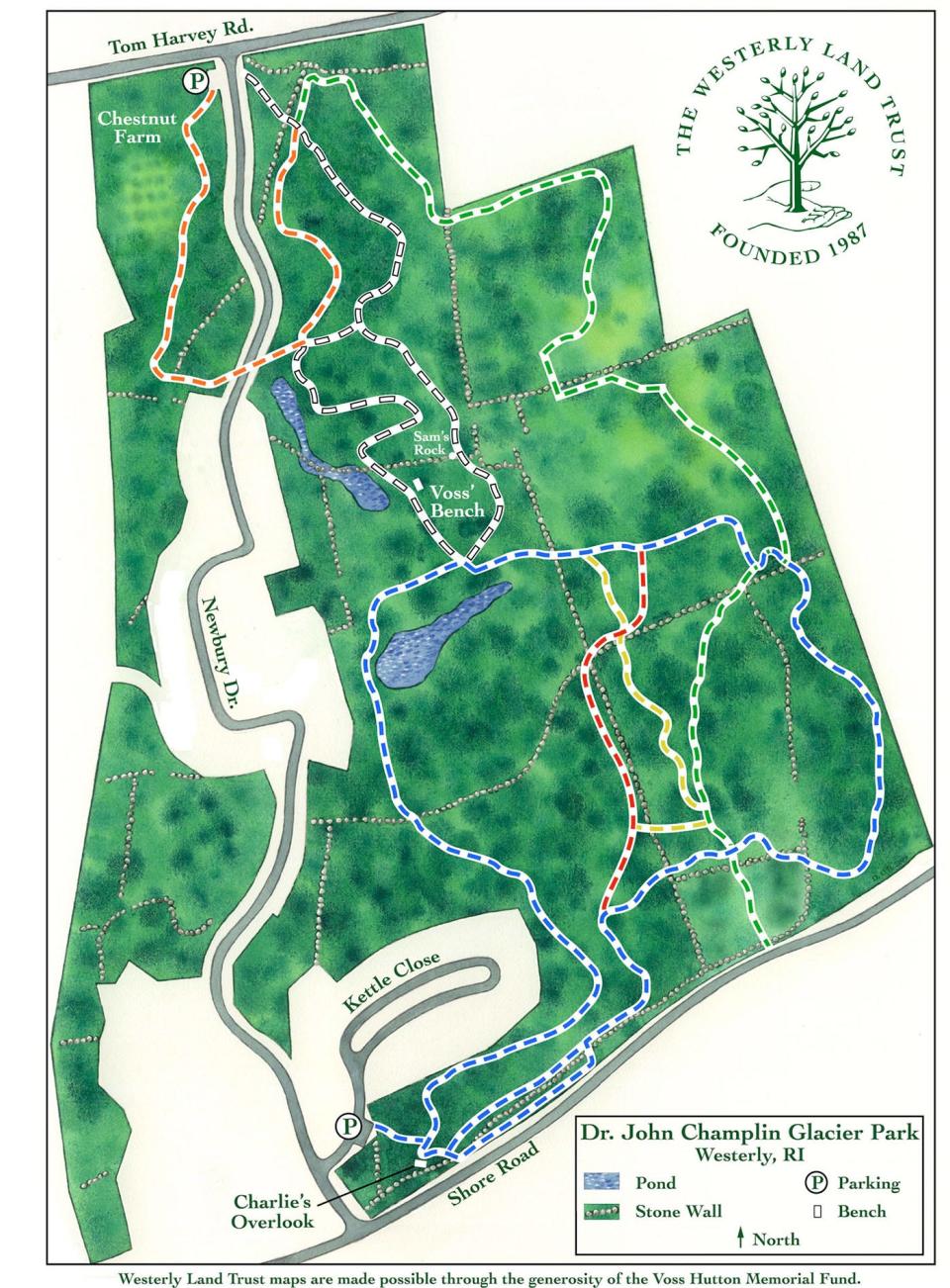
The 134-acre park, and five miles of trails, are named for Champlin, a well-known local doctor and businessman who died in 1938. His estate transferred the land in 2004 to the Westerly Land Trust, which manages the property.
Walking RI: Up for a hiking challenge? Tackle this section of the North South Trail in Exeter
Walking RI: What's missing from Tiverton's Basket Swamp? A key tree for Native peoples
I decided to explore the preserve, and learn more about the glacial geography, by setting out on the orange-blazed trail at a trailhead off Tom Harvey Road. I walked south on a wide, flat path through an area called Chestnut Farm, where more than 50 blight-resistant chestnut tree saplings were planted in 2007. The trail wound through a mixed hardwood forest with fields on the right before turning east along the edge of a development called Winnapaug Cottages. The trail then crossed Newbury Drive before reentering the woods.
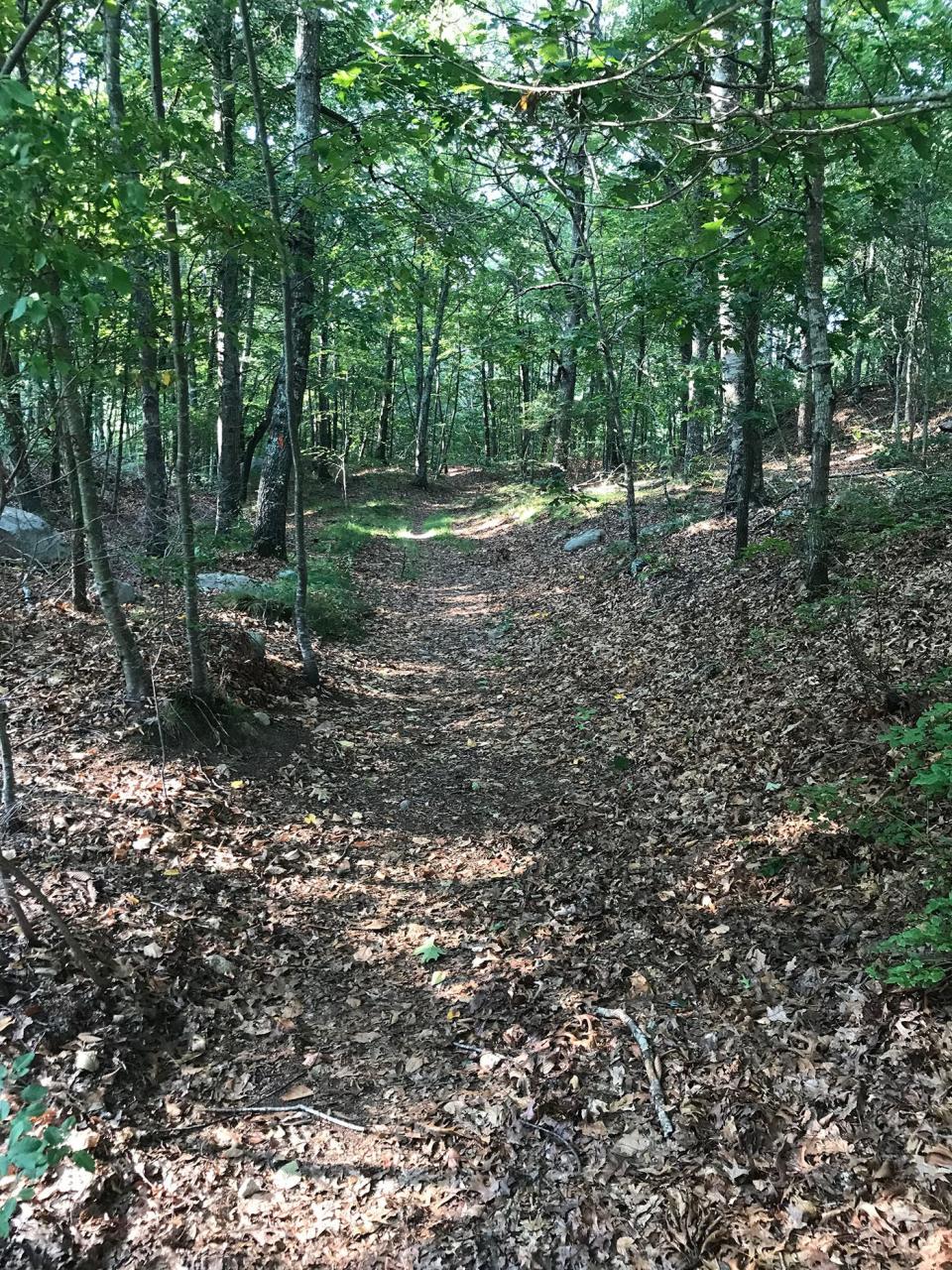
Coming to a junction, I chose to walk the perimeter of the preserve by picking up the blue-blazed path, one of a network of interconnected, color-coded trails. Just ahead on the right, a side spur opens to what looks like a large field but is actually a shallow pond that freezes in the winter and is used by ice skaters and hockey players.
Walking RI: Hike along the Narrow River at former Girl Scout camp in North Kingstown
Walking RI: Hike the 'Big Hill' in Cumberland, where skiing was once a favorite winter pastime in RI
The trail then ran along and through gaps in several stone walls. Before the Europeans settled here and built the walls to mark property lines or enclose livestock, the Niantic and Narragansett tribes for thousands of years lived, farmed, fished and hunted along the coast.
At one point, the trail climbs a small ridge to a rustic bench that faces west. Called Voss’ Bench, the site is a tribute to Voss Hutton (1909-2003), requested by his daughter, Cynthia Lafferty, the first president of the Westerly Land Trust.
Above the bench, a sign is lettered with an Irish blessing. It begins “May the road rise up to meet you” and ends with “And until we meet again, May God hold you in the palm of his hand.”
Walking RI: Discover a hidden gem of forest, ponds and wetlands in Little Compton
Walking RI: Spectacular bay views and Colonial and tribal history at Mount Hope Farm
What's a kettle pond and how does it form?
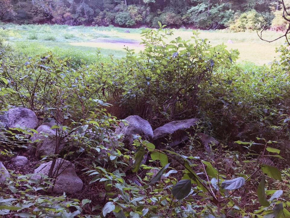
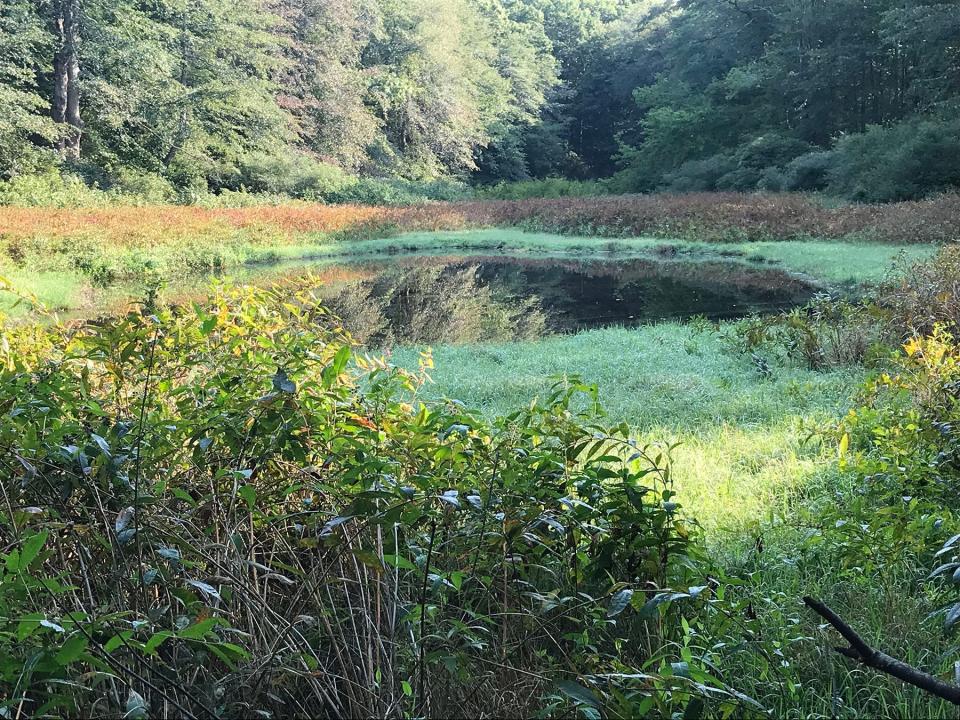
After sitting there for a few minutes, I continued on the path that ran downhill to a pool on the left that was surrounded by a grassy rim. The circular body of water is a kettle pond, formed when a receding glacier stagnated and a huge chunk of ice broke off and settled in the ground. As it melted, the kettle pond was formed. The pool, below the groundwater table, is not fed by brooks or streams. The glaciers also left small mounds of gravel called kames around the pond.
After studying the pond, I kept going on the blue-blazed path and passed several scatterings of granite stones with sharp edges. These were different from the huge, rounded boulders, called erratics, that were deposited by the retreating and melting glaciers. This set of gray blocks was left from a quarrying operation, probably in the late 1700s or early 1800s.
Walking RI: Discover why hikers and anglers love the 'wild and scenic' Beaver River
Walking RI: Want to practice some rock climbing? Head to Connors Farm in Smithfield
The quarry workers used a technique called "plug and feather" boulder quarrying to cut bedrock and erratics into the rectangular shapes with square corners that were used for construction. They drilled holes every few inches in a straight line across the rock by using a plug or star drill and a hammer. Two shims, called feathers, were inserted in the hole and a plug was wedged between the feathers to split the stone.
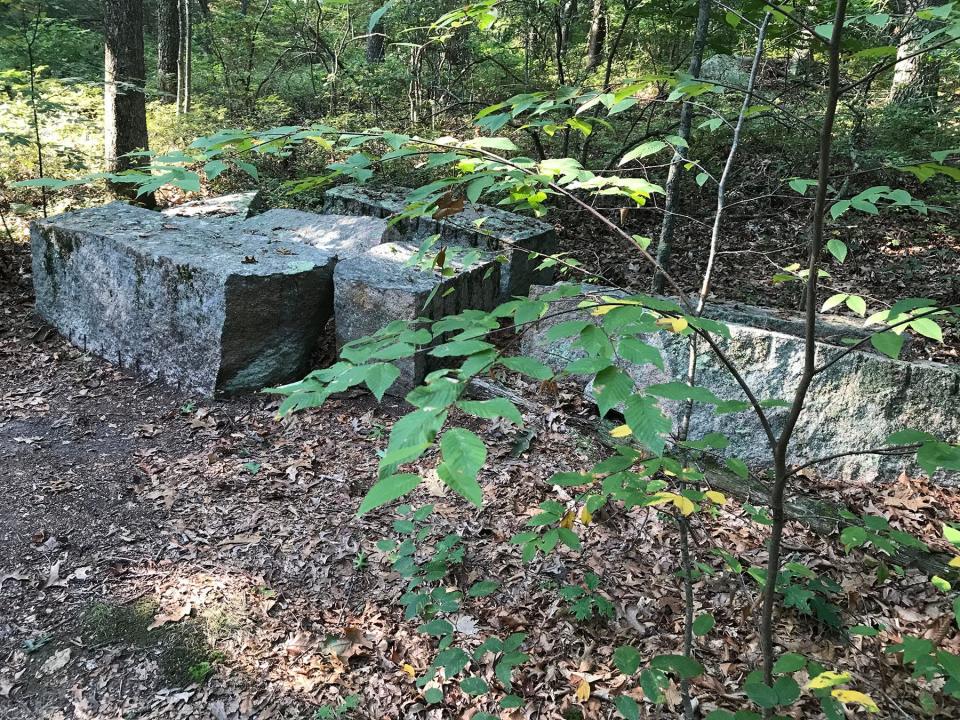
Broken or partially defective quarry stones were left behind, and the practice was replaced by the 1870s by more efficient deep pit, commercial quarrying.
Catch a glimpse of Block Island from Charlie's Overlook
After inspecting the stones, I continued following the trail up and down ridges, with houses visible through the trees on the right. The trail reached Charlie’s Overlook, named for Hickox, who helped create the preserve and develop the trails.
I sat in the sun on a smooth erratic, took in the view to Block Island Sound and studied several educational signs posted at the overlook. I learned that from 15,000 to 21,000 years ago, a series of glaciers crept down from Canada and covered Rhode Island and points south.
Walking RI: Follow in the footsteps of Trappist monks in Cumberland
Walking RI: Tillinghast Pond's trails are part of something special and well worth a visit
The ice sheets, some several miles thick, acted like bulldozers that scraped and dug through the terrain while pushing soil, sand, gravel and boulders in front of them.
When one of the glaciers halted and began to melt, it dropped what it was pushing to form a ridgeline, called a terminal moraine. That moraine stretches from Long Island to Nantucket and helped shape Block Island.
After that glacier receded, another swept down from the north but didn’t get as far south as the earlier ice sheet and formed another ridge, called a recessional moraine, that runs through Westerly and Charlestown and along the coast northeast to Narragansett.
The ridge I walked on in Champlin Glacier Park is part of the recessional moraine.
Walking RI: Mingle with birds, beavers, mink and more at Exeter's Fisherville Brook refuge
Walking RI: Ninigret National Wildlife Refuge harbors naval, tribal history
From Charlie’s Outlook, I could see that the glaciers also left an outwash plain, a gently sloping deposit of sand, gravel and sediment called till that was flushed from the front of the glaciers by runoff streams.
Past the outlook, a short path downhill led to a trailhead, information kiosk, parking lot and a development of senior citizen condominiums at the south end of Newbury Drive.
I returned to Charlie’s Outlook and headed northeast on a trail that parallels Shore Road. I learned later that along the road was once farmland, and the Oaks Inn, which included a restaurant, resort and stables where guests could ride horses. A nearby polo field was used by people from Watch Hill.
Walking RI: Looking for a great birdwatching spot? Try this former Navy site in North Kingstown
Walking RI: Best place for a hike and osprey spotting? Try the Great Swamp in South Kingstown
Site of a coastal defense installation during World War II
After the attack on Pearl Harbor, the U.S. military seized the property and set up a shoreline defense to monitor enemy submarines and protect the coast. Placements for four 155 mm guns were installed on the glacial moraine, and the old inn was used as a barracks for the soldiers.
After following the road for a short distance, the trail ducked into the woods and crossed several side spurs. I stayed on the blue-blazed trail, which ran below a high ridge on the right before picking up the green-dot trail. The path ran along the edge of the preserve, flanked a valley on the left and then ran northwest back to the trailhead.
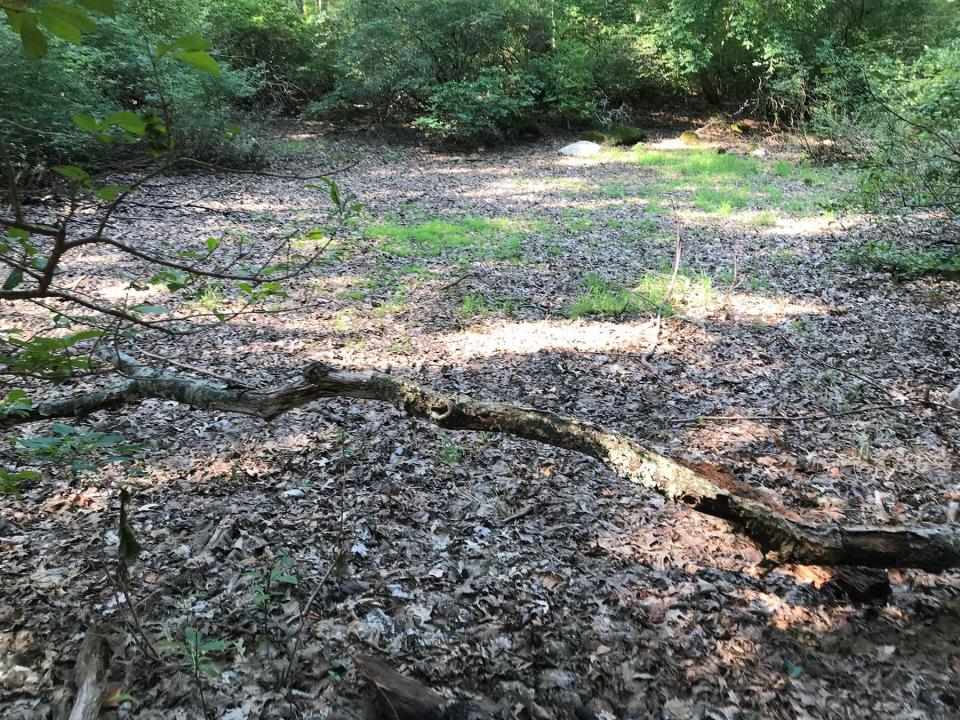
I had a little more time and took the white-blazed trail south and found a dried-up, leaf-covered vernal pool. But by late winter and early spring, the depression will fill with runoff from snowmelt and groundwater and become a breeding ground for amphibians and invertebrates, including frogs, toads, salamanders and fairy shrimp.
Walking RI: Retracing Thoreau's 1854 hike through Providence
Walking RI: Rediscover Providence's Roger Williams Park on a serene hike around its ponds
At that point, I turned around and retraced my steps to the trailhead. In all, I walked about 3 miles over 90 minutes.
While doing some research after my hike, I read that Hickox, a Westerly native who became a geology professor, would often lead small groups across the preserve and up and down the moraine to explain how the glaciers shaped the land. The terrain is a perfect, outdoor classroom for his lectures.
John Kostrzewa, a former assistant managing editor/business at The Providence Journal, welcomes email at johnekostrzewa@gmail.com.
This article originally appeared on The Providence Journal: Hike through Ice Age terrain at Champlin Glacier Park in Westerly, RI

