I hiked the 38.5-mile Trans-Catalina Trail so you'll know what to expect
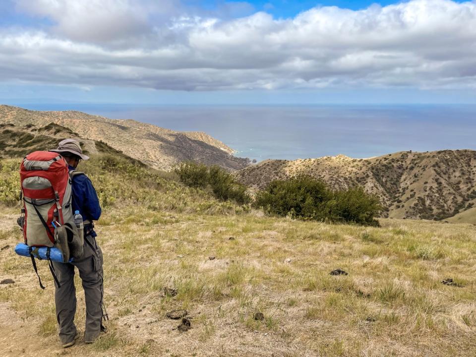
As I hiked up a steep pitch on the west end of Santa Catalina Island, the straps of my 30-pound pack dug into my shoulders, no matter how many times I cinched the waist belt to balance the load. There are no switchbacks on this part of the Trans-Catalina Trail, just a dirt path that points upward. I didn't enjoy this but plodded on.
I have hiked on Catalina for decades but had never pieced together its routes until I hiked the Trans-Catalina Trail, or TCT, in mid-April. It's a 38.5-mile route of extreme ups and downs that leads from the resort town of Avalon, on the east side of the island, to the less-visited northwestern beach of Parsons Landing, its farthest point, and the trail's end at Two Harbors.
"You never walk on flat ground," said Tony Budrovich, chief executive of the Catalina Island Conservancy, which manages the trail and open space that make up 88% of the island. "You're either going uphill or downhill. That is highly challenging for a hiker, but the payoff views when you get to the top of the ridges and the beauty of going into the crevices and valleys make you feel like you've really gone somewhere exotic."
Budrovich is right. The allure of the TCT makes you forget its grueling parts and leaves you awestruck at the sparkling ocean views and beach-side campgrounds, so unexpected and remote for a place an hour's boat ride from L.A.
Since the trail opened six years ago, it has boosted tourism to the lesser-known west side of Catalina. The TCT also has become a dream destination for hikers and backpackers who can complete it in either direction. Each year about 8,000 trekkers hit the trail, making competition stiff for permits to reserve the four campgrounds along the way.
One mystery: How did the conservancy come up with a 38.5-mile trail on an island that's only 22 miles long? From Avalon, the TCT crosses the interior of the island to Two Harbors, continues on the high inland route to Parsons Landing, then curves back along the lower coastal road, making a small loop in the final miles. The lone restaurant at Two Harbors hosts many impromptu TCT victory parties.
The campgrounds along the TCT are cushy by backpacking standards. Three are on or near beaches and all have drinking water (leave your filter at home) and toilets. Most people plan on three or four days to complete the trail. I chose four days; here's what my trip was like.
Day 1
Avalon to Black Jack Campground
10.7 miles
My friends and I took the 8:45 a.m. boat from San Pedro to Avalon and found the conservancy's new office (708 Crescent Ave.), the official start of the hike. "Trailhead: Adventure Starts Here" read the sign outside. From there, we walked through Avalon, then turned inland toward the trail at Catalina Avenue.
Shops selling beignets and bagels were tempting but didn't open until later, so we pressed on, stopping at Chet's Hardware (117 Catalina Ave.) to pick up fuel canisters for our backpacking stoves (you can't bring them on the boat for safety reasons).
After a few miles, the trail led uphill, winding through the interior, sometimes along roads but often along single-track trails. Chaparral and island oaks lined the route until we reached Black Jack Campground.
On a midweek day in April, all 10 sites were bustling with campers hiking the TCT. This is the sole campground without ocean views, though you can find some by hiking nearby Mt. Orizaba, the island's high point at 2,097 feet above sea level.
We woke to the sound of grunts and branches snapping. Two of the island's famed bison had entered the campground to rub and scratch themselves on shrubs and trees. People took photos with their phones (at a distance; there are signs everywhere that warn you to stay at least 125 feet away). We waited for the bison to move on, ate breakfast and started to hike.
Day 2
Black Jack to Two Harbors
13.5 miles
Leaving Black Jack, the trail skirted the island's tiny airport (which is open for breakfast and lunch) before dropping down to the west-facing side of the island. We meandered along hillsides before reaching Little Harbor, a sweet beach with campgrounds.
We lingered at site 11, nearest the beach, to have lunch. I was reluctant to leave and wished we had added an extra night so we could have stayed here. I looked up and spotted a wedding in progress high on the bluffs of the next cove.
If it's hot, Little Harbor is a good place for a swim, but in April it was a little too cool for a plunge in the ocean. We turned our backs on the beach and headed for Two Harbors, which meant a steep climb up an ocean-facing canyon.
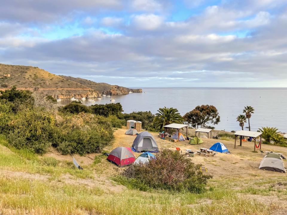
Catalina showed off its rugged good looks as we climbed to reach a small hikers shelter at the top of the ridge. From here, we crossed the island's width to Two Harbors, which was a metropolis compared with the quiet coves we had left behind.
Two Harbors has a restaurant and small grocery store as well as a small stretch of beach. I ditched my packed lunch in favor of chips, hummus and fresh coffee. The campground here is the largest on the TCT with 47 sites, some on the bluffs with great views, others closer to the beach.
Day 3
Two Harbors to Parsons Landing (spine route)
6.6 miles, plus 9 miles round trip to Starlight Beach
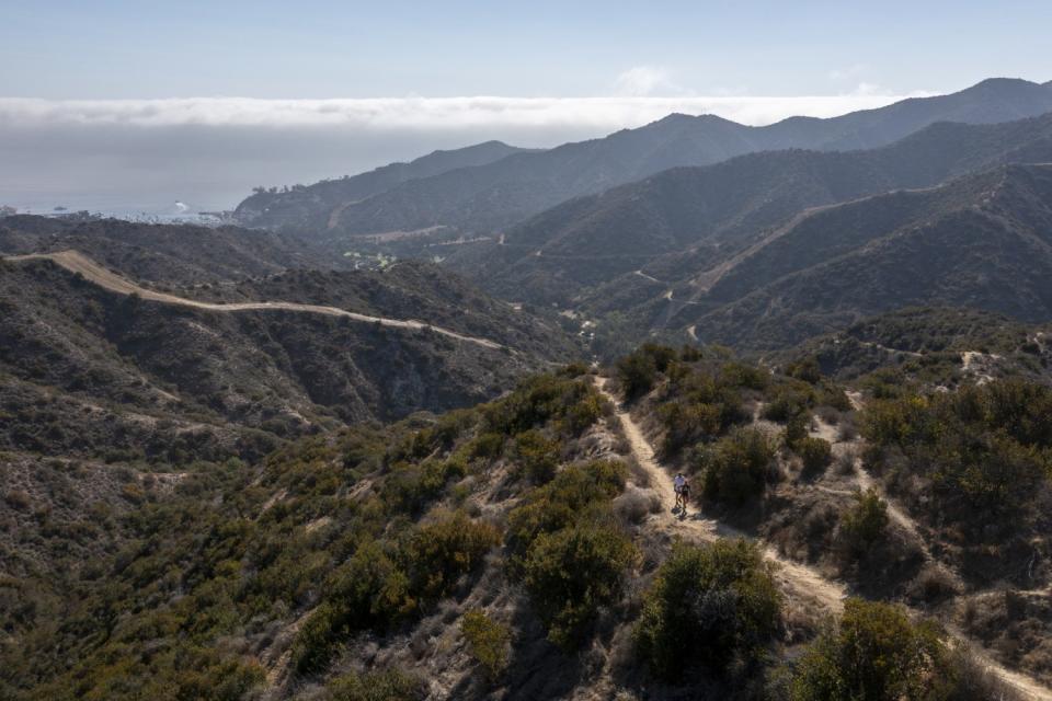
The trail from Two Harbors took us up the inland route, a.k.a. the spine, the steepest and hardest part of the TCT. It's straight uphill, then straight downhill along Fence Line Road. My legs wobbled as I started down, and I relied on my quads to keep me upright until I reached the bottom. Every step felt as if it was a fight with gravity; I tried hard not to stare at the sheer drop. I kept my eyes on my feet.
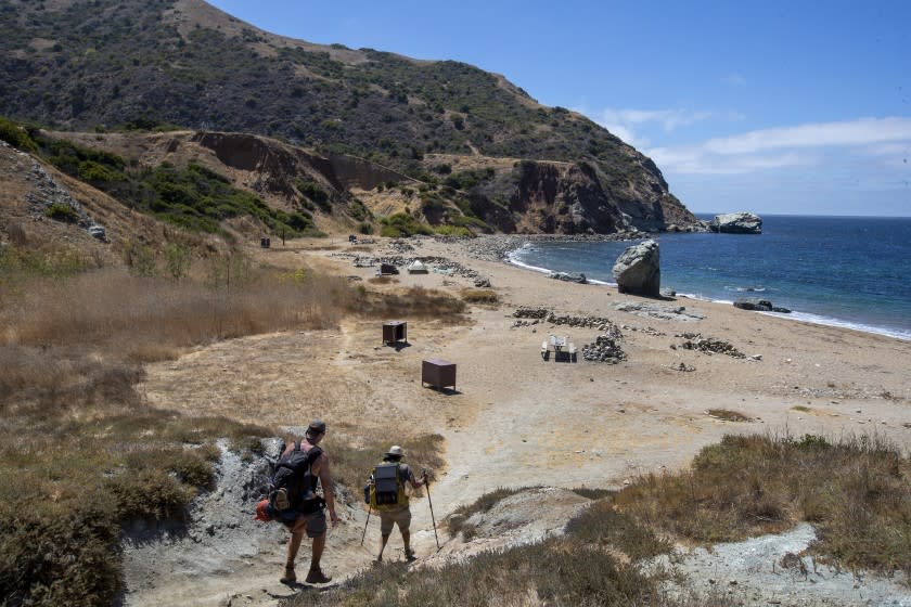
The knee- and leg-pummeling descent took us to Parsons Landing, a quiet beach with six campsites, all on the sand. Upon arrival, I met Kendra, who was scouting the trail and making plans to return to do the entire route. "Oh! You have campsite 1," she said. "It's the best." She wasn't the first to tell us this.
It was easy to see what made the site so special: Bluff walls on either side made it completely private, with the ocean about 20 feet away.
We dumped our gear, set up tents and headed for Starlight Beach, on the west end of Catalina. The out-and-back to the beach, a destination that had been on my list for years, added nine miles round-trip. (It's no longer part of the TCT.)
We followed old roads and single-track trails until we found the small, deserted, dark-sand beach. We saw no one, coming or going. It was late in the day and we couldn't linger, but I vowed to return. The little crescent beach felt as if it was the most remote place on Earth. Returning to camp, we ate dinner and headed for our tents. The sound of the ocean pummeling the rocks lulled me to sleep.
Day 4
Parsons Landing to Two Harbors (coastal road)
7.7 miles
The return trip to Two Harbors followed the flatter coastal road along many developed camps and bays that open seasonally. The trail stayed high above the ocean, which meant we could look down on Emerald Bay, Howland's Landing and Cherry Cove. Sometimes cars and four-wheel vehicles ferrying gear stirred up dust as they passed. When aptly named Ship Rock came into view, we knew we were close to the finish. The final steps were glorious.
At Two Harbors, we spent lazy hours sitting and congratulating ourselves for finishing. With the TCT behind us, I found myself forgetting the tough parts and recalling the spectacular beaches and views. I'll be back.
If you go
The Trans-Catalina Trail is very exposed; it's best to hike in spring and late fall when temperatures are cool. Hiking permits are free. You need to reserve campgrounds at least two months in advance; they fill quickly, especially at Parsons Landing. Reserve online at catalinaconservancy.org or by calling (310) 510-2595 (I found this easier to do by phone).
Be prepared with dates you want to reserve at all four campgrounds. Sites cost an average of $30 per person per night, depending on the time of year. A $30 membership, however, with the Catalina Island Conservancy discounts costs by 50%.
Boats to Catalina sail from San Pedro, Long Beach, Dana Point and Newport Beach. Rides cost $70 to $76 round trip.
This story originally appeared in Los Angeles Times.

