Hiker's Path: A day well spent at Starve Hollow Recreational Area
In keeping with my summer theme of hiking places closer to home, I chose to head south this time, to the Starve Hollow State Recreation area.
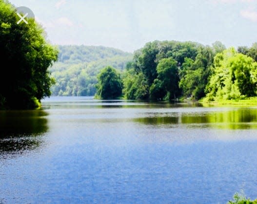
When it was first constructed in 1938, Starve Hollow Lake was the largest man-made body of water in Indiana. The lake now covers 145 acres. Though it’s no longer the state’s largest lake, the area still offers some of the best fishing in Southern Indiana.
Starve-Hollow State Recreation Area encompasses approximately 280 acres and is a part of the bigger 18,000-acre Jackson-Washington State Forest that surrounds it. The area provides fishing and boat rental on the Lake, swimming, hiking and mountain biking on nearby trails, camping and a nature center.
Starve Hollow has several hiking trails available to hike on. Trail maps are available at the gatehouse at Starve Hollow.
The day I visited this place, the weather was on the warm side.
You could say it was very warm!
The sun was shining, the sky was blue, and there were white, billowy clouds above me. It was a good day for a hike.
I enjoyed the drive down to Starve Hollow. It is 49 miles from Spencer to this recreation area.
After I arrived, I retrieved a map from the gatehouse.
I showed the gate attendant my Indiana State Park pass that would get me in. They charge the same entrance fee as the Indiana State Parks.
I had picked out two different trails that I wanted to hike but settled on the shorter distance of the two: the Vista trail.
This trail is only 1.5 miles in length but is considered “very rugged” in ease of hiking.
This trail passes over some rugged hills and deep valleys. It is a loop trail and I accessed it from another loop trail: the Lakeshore loop trail.
I took off down the trail with high expectations. It had been quite a while since I had visited this place. I was ready for the day and what it might bring.
It didn’t take long for this trail to live up to its name as being “very rugged”. I passed through some beautiful hardwood forests with a lot of dense undergrowth. Overhead I was protected from the intense sun from a beautiful canopy of leaves, with their branches intertwining, with the end result of very much appreciated shade.
The hills were rugged and the valleys were beautiful.
I came to a set of old concrete steps and as I descended down the trail on the steps, I couldn’t help but feel a sense of nostalgia. Carved into the steps was the year “1976”. An important year in our nation’s history. That year was the 200th anniversary of the “ Declaration of Independence”, for our country.
The trail also provided nice views of the lake. Thus its name: the Vista Trail. The very definition of a vista is, “a beautiful view”.
I continued on my walk until I finished the loop.
It had been a good hike and a day well spent. I might mention that Starve Hollow has several other trails and they connect to each other. The trails are well marked. Altogether there are about eleven miles of trails around the lake.
Starve Hollow Lake is a beautiful place to visit.
The address for Starve Hollow is 4345 S. 275 West, Vallonia, Indiana. You can take State Road 446 South out of Bloomington. Drive 24 miles to US Highway 50. Drive 16 miles to South State Road 135. Follow signs.
A quote for your week: “Live in the sunshine. Swim in the sea. Drink in the wild air”. - Ralph Waldo Emerson - American Essayist - 1803-1882
Until the next trail,
Susan
This article originally appeared on Evening World: Hiker's Path: A day well spent at Starve Hollow Recreational Area
