Up for a hiking challenge? Tackle this section of the North South Trail in Exeter
EXETER — After I retired five years ago, I spent part of that summer hiking the North South Trail — a 78-mile route that runs from Blue Shutters Beach in Charlestown to the Buck Hill Management Area in Burrillville.
Several friends and I hiked the trail in seven legs of about 11 miles each, and it turned out to be a refreshing experience that helped me begin the next phase of my life.
During my walks since then, I’ve crossed the North South Trail or walked short segments of it many times — all of which brought back great memories. I recently recalled one wild, remote section of the trail that passed through a glacial boulder field in the eastern slice of the Arcadia Management Area, a 14,000-acre, state-run preserve.
I decided to hike it again.
Walking RI: A streaming history lesson along Exeter's Roaring Brook
Walking RI: What's missing from Tiverton's Basket Swamp? A key tree for Native peoples
Walking RI: 5 great hikes with ocean views
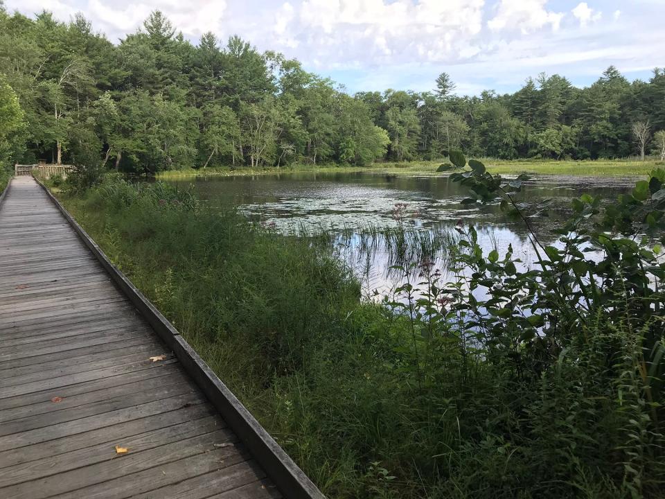
Two buddies and I set out from the trailhead at a dirt lot at Upper Roaring Brook. While they put on their gear, I walked a short distance west on the North South Trail to a boardwalk over a brook that runs from a small, 4-acre, idyllic pond. It was calm and quiet, with mist coming off the water, and set just the right tone for an early-morning hike deep in the woods.
We started out by heading east and walked around a red, barred gate on a gravel road. In a short distance, the yellow-blazed Arcadia Trail opened on the left, and we took it into a thick oak and maple forest. Through the trees to the left, we caught a glimpse of Upper Roaring Brook.
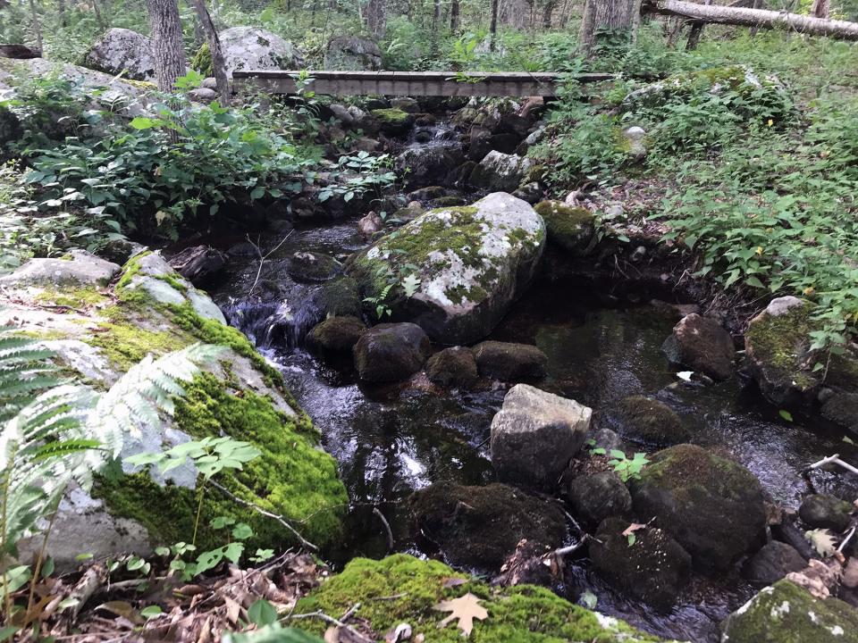
The trail took us up and down small ridges and then followed a stream bed as it circled to the northeast and then east. We then crossed a wooden bridge over a brook before reconnecting with the gravel road we had started out on.
Walking RI: Hike along the Narrow River at former Girl Scout camp in North Kingstown
Walking RI: Drought bares hiking trails often under water near Brushy Brook in Exeter
Challenging terrain, vulnerable to storm damage
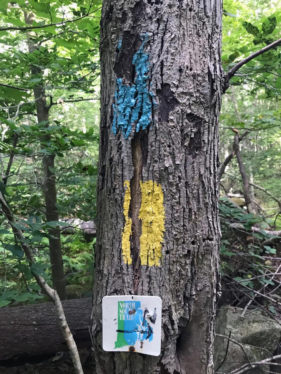
We turned right and in a hundred yards or so picked up the trail blazed in both blue and yellow, marking the North South Trail and the Arcadia Trail, which run together for a while. Turning into the woods, with Tefft Hill to the east, we headed south on a trail lined with ferns and beech trees that started out flat and then rose and fell over ridges.
After about a mile, we passed a hiker heading north who cautioned that the trail ahead was pretty overgrown. He was right. We made our way through brambles, heavy brush and vines in a couple of places and had to climb over a few downed trees.
Because of its topography, the area is subject to blowdowns during heavy windstorms and other extreme weather events. At least two microbursts in the last 15 years have caused major damage, including one that ripped a 100-yard-wide swath through the forest, snapping off treetops and toppling large trees.
Walking RI: Discover a hidden gem of forest, ponds and wetlands in Little Compton
Walking RI: Spectacular bay views and Colonial and tribal history at Mount Hope Farm
The area’s trail corridors are maintained by the Rhode Island Department of Environmental Management’s Division of Agriculture and Forest Environment, with help from volunteer groups such as the North South Trail Club, the Appalachian Mountain Club (AMC), the New England Mountain Bike Association, the Rhody Rovers and the Rhode Island Nursery and Landscaping Association.
What created a field of boulders?
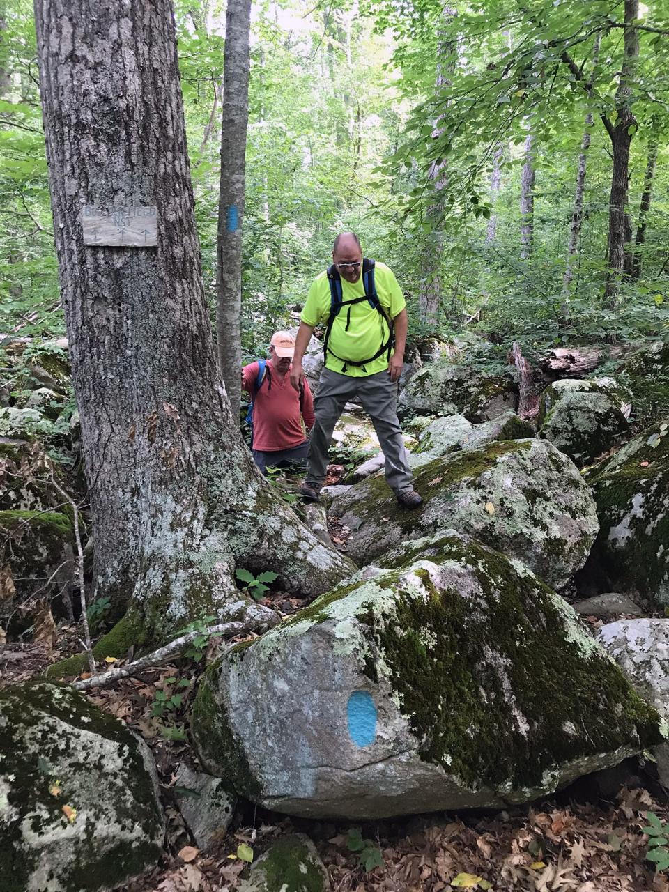
Just ahead was a large field of boulders that I remembered from my hike in 2017. A spur trail opened on the right that bypassed the obstacles, but we went straight ahead.
The boulders, rounded and covered with moss and lichen, were side by side and sometimes on top of each other. Small trees, as well as thick, thorny vines and bushes, grew between them and made the crossing a bit of a scramble. I had to use my hands for balance in a few spots.
Walking RI: Discover why hikers and anglers love the 'wild and scenic' Beaver River
Walking RI: Want to practice some rock climbing? Head to Connors Farm in Smithfield
The scattering of boulders stretches from the old Dawley Park Pavilion on Route 3 to Browning Mill Pond to the west. They were deposited by a moving ice mass, called the Laurentide Ice Sheet, that swept down from Canada 18,000 to 20,000 years ago. The glacier scraped and plucked granite from bedrock, outcroppings and ledges, and as it crept across the land, the sharp edges of the granite were chipped off, ground down and rounded as the rocks hit each other and were tossed and rolled by the ice.
When the glaciers began to melt and recede, they dropped the boulders, called erratics, haphazardly across the terrain. They’ve been there ever since.
Walking RI: Follow in the footsteps of Trappist monks in Cumberland
Walking RI: Tillinghast Pond's trails are part of something special and well worth a visit
Mysterious cairns in the forest
After crossing a section of the boulder field, the trail opened up under oak and beech trees and was easier to navigate. At one point, on the right, I saw a half dozen cairns about 4 feet high in no apparent order. I explored the area and the piles of stones but came to no clear conclusion about why they were there or who built them.
Further down the trail on the left is a bridge of broken concrete over a stream bed. I inspected it and found a small rock dam with a gap in the middle where a board could be placed to hold back water, perhaps to create a small farm pond or fire pond.
Continuing south, we entered a pine forest on a pine needle-covered path and reached a T-shaped junction just before West Baker Pines Road.
Walking RI: Looking for a great birdwatching spot? Try this former Navy site in North Kingstown
Walking RI: A step-by-step guide to beautiful Stepstone Falls
The blue-blazed North South Trail went left, but we went right on the yellow-blazed Arcadia Trail and walked through the gaps in an extensive set of stone walls and enclosures that must have been part of a farm settlement.
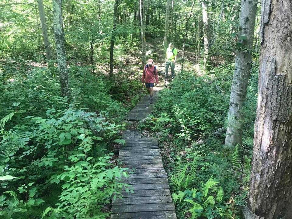
Well-maintained network of boardwalks and bridges
The trail then crossed a series of well-built boardwalks, footbridges and bog bridges, some with non-skid surfaces, over wetlands and streams. The North South Trail Club, the AMC, and the Boy Scouts have helped to maintain the bridges over the years.
When we reached an intersection at the confluence of several streams, the white-blazed Arcadia Crossover trail went right and the yellow-blazed trail continued left. We saved the crossover for later and took the yellow-blazed trail, which ran along a narrow brook and then through the woods before crossing KG Ranch Road.
We walked past a number of stone walls, enclosures and cellar holes from farm settlements. One of them was called the Richmond Sisters’ Farm, with a stone foundation and a root cellar cut into a hillside. Two years ago, the DEM and the Audubon Society’s Youth Conservation League cleared encroaching vegetation from the foundations.
Walking RI: Retracing Thoreau's 1854 hike through Providence
Walking RI: Rediscover Providence's Roger Williams Park on a serene hike around its ponds
Along the trail, I saw plenty of chicken of the woods mushrooms and several other types of fungi as the path flattened, crossed a fire road, rose and fell over small hills, passed a field on the left and finally headed downhill to emerge at Arcadia Road and the Arcadia Forestry Headquarters.
Vandalism closes one section of walkway
We stopped and rested there, read the bulletins on an information board and then turned and retraced our steps on the yellow-blazed trail to the crossover trail we had passed before. We took the white-blazed path north all the way to the gravel road where we'd started out.
After turning left on the Tefft Hill Trail, we took a short walk west to a spot on the banks of Lower Roaring Brook, where a sign said the wooden, handicapped-accessible walkway over the water is closed, a victim of some recent vandalism. The DEM is meeting with contractors to discuss rebuilding the walkway.
Walking RI: Take in the fragile beauty of Warren's Touisset Marsh during a coastal hike
Walking RI: At Trustom Pond in South Kingstown, silence is golden
Walking RI: A birder's paradise by the shore in Middletown
The vandalism was an unfortunate blemish at the end of an interesting hike through largely unbroken, undeveloped forest. Overall, we walked 5.3 miles over three hours.
The hike brought back pleasant memories of my walk in 2017 on the North South Trail. The natural, wooded area and the boulder field haven’t changed much. I hope others, at no matter what stage of their lives, get a chance to experience a remote part of Rhode Island.
John Kostrzewa, a former assistant managing editor/business at The Providence Journal, welcomes email at johnekostrzewa@gmail.com.
This article originally appeared on The Providence Journal: Want a hiking challenge? Tackle this leg of RI's North South Trail

