Historic rainfall to continue deluging South Central states


With heavy rain pounding the South Central states day after day, rainfall amounts have soared to historic levels as residents gear up for more severe weather and damaging and life-threatening flooding throughout the week.
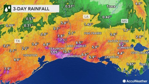
This is already the third-wettest May in recorded history for Lake Charles, Louisiana. The city has received more than 17 inches as of the midday hours on May 19, which is nearly six times the average amount of rainfall during the first 18 days of the month.
A total of 12.41 inches of that fell on Monday alone, which the third-highest single-day rainfall total in Lake Charles' history.
 |
This month has also already reached number one for wettest Mays in Victoria, Texas, as the city reports over 16 inches of rainfall with well over 4 times as much rain as usual. This tops the second-wettest May from 1993 by about 2 inches.
"Rounds of rain and thunderstorms have inundated much of the south-central U.S. since Monday, especially for many in Texas and Louisiana, and relief is not expected until late this week," said AccuWeather Meteorologist Adam Sadvary.
 |
The National Weather Service office in New Orleans issued a Flash Flood Emergency for the southern portion of East Baton Rouge, Louisiana, on Monday night.
Parents were seen bringing their children home from school via kayak and canoe as the streets were flooded across southern Louisiana. Boat evacuations were underway early Tuesday morning in flooded parts of Baton Rouge.
 |
Three-day rainfall totals from May 16-19, 2021. |
Intense rainfall is not likely to let up across the South Central states as the week progresses either.
A slow-moving disturbance tracking eastward through the Southwest will act as a trigger for daily storm activity from the Rockies eastward across Kansas, Oklahoma and Texas through midweek, according to AccuWeather Lead Long-Range Senior Meteorologist Paul Pastelok.
 |
This image captured early Wednesday afternoon, May 19, 2021, shows all of the flood alerts in effect across the South Central states. (AccuWeather) |
"Strong high pressure sitting idle over the southeastern U.S. will continue to funnel substantial amounts of moisture out of the Gulf of Mexico and through the south-central Plains for most of the week ahead," Sadvary said.
This strong onshore push of warm and moist air out of the Gulf of Mexico will act as the fuel source for multiple rounds of rainfall, according to Pastelok.
 |
This rainfall can spell trouble for the areas of the South Central region which had already received more than enough rain this month.
CLICK HERE FOR THE FREE ACCUWEATHER APP
"Not only is there a likelihood of life-threatening flash flooding during the event but also a slow-motion disaster brought on by rising river levels. High water may take days if not a week or more to recede below flood stage," AccuWeather Senior Meteorologist Alex Sosnowski said.
"Watersheds throughout the region have been overwhelmed with near-historic rainfall so far this week, and any additional rain can easily lead to flooding of fields, roads and urban areas," said Sadvary.
Commerce is likely to be affected in the region and there is some potential for petroleum refineries to be impacted.
Cities like Fannett, Texas, and Ganado, Texas, received over 13 inches of rain early this week. Houston has reported nearly twice its normal rainfall amount so far this May, while New Orleans has had nearly five times its normal rainfall.
"The repeated downpours are likely to bring areas of standing water and flooded yards, parks and fields," said AccuWeather Meteorologist Jake Sodja. This can cause damage to farms or delay planting of new crops.
High river levels from past rain also means flash flooding can be easy to achieve this week.
"With many creeks and rivers already at elevated levels, more heavy rain for the region will threaten widespread flooding in areas near bodies of water," Sadvary said.
Not everywhere in the South Central region is completely waterlogged, though. About 28% of Texas is under severe drought according to the United States Drought Monitor, and about 66% of the state is abnormally dry.
 |
"Small amounts of rain delivered with these storms, overall, could be beneficial to helping alleviate drought concerns, especially in western Texas and New Mexico that are still in severe drought," said AccuWeather Senior Meteorologist Courtney Travis.
The storms can still present a risk as they unload hail and gusty winds across Texas and Oklahoma.
"The heaviest rain and highest flooding threat is expected across eastern Texas; however, any locale that experiences multiple rounds of thunderstorm activity could also deal with flooding issues," said Pastelok.
In addition to flooding, parts of the southern U.S. have already been damaged by tornadoes and softball-sized hail this week.
A tornado tore through Bell County, Texas, on Sunday afternoon. According to the National Weather Service's (NWS) Storm Prediction Center, multiple homes sustained minor damage from the tornado, and some outbuildings were also damaged or destroyed.
On Monday, winds gusted past 70 mph in Dimmitt, Texas, with gusts in the 60s reported elsewhere in Texas and Oklahoma. Hail fell across Texas as well on Monday, measuring around the size of baseballs, including in South Haven, Texas, and Forsan, Texas.
Late Tuesday, damaging storms rolled through the Houston metro area, leaving tens of thousands of residents without power. Over 10 inches of rain fell on Wednesday along the Texas coast, including in Victoria and Port Lavaca, Texas.
 |
Stormy weather will continue on Thursday in the South Central states, moving farther to the southwest into deep southern Texas. Drenching thunderstorms are expected from Little Rock, Arkansas, to McAllen, Texas.
Travel can quickly become treacherous under these conditions.
"Anyone who is traveling and experiences a roadway submerged in water is urged to turn around and find an alternate route if possible," warned Sadvary.
AccuWeather meteorologists recommend that motorists be aware of the changing weather conditions, as travel can quickly become dangerous as roads become flooded.
"The message is the same...prepare for rain and prepare for river flooding," said the National Weather Service West Gulf River Forecast Center.
 |
By Friday, widespread rainfall totals of 2-4 inches are anticipated from far southern Texas and Colorado to Illinois and Louisiana. The highest rainfall amounts are forecast for eastern Texas, including Tyler, Texas, and Beaumont, Texas, where as much as a foot of rain can fall.
"The atmospheric pattern will continue to be conducive for thunderstorm activity across the Plains late week and this weekend," said Pastelok.
Forecasters suggest there's no clear end to thunderstorms in sight for the South Central states.
The Gulf of Mexico will remain "open for business" with a southeasterly flow continuing to pump warm and moist air northward through the Plains, according to Pastelok.
Keep checking back on AccuWeather.com and stay tuned to the AccuWeather Network on DirecTV, Frontier, Spectrum, FuboTV, Philo, and Verizon Fios.
