History road trip: Visiting Fort Bowie and Apache Pass in Arizona
A visit to Fort Bowie National Historic Site in southeastern Arizona requires some effort. It’s a long drive into Cochise County, the last mile on a dirt road, and then that’s followed by a 1.5-mile hike just to reach the remains of the fort. Yet it will be a day you won’t soon forget.
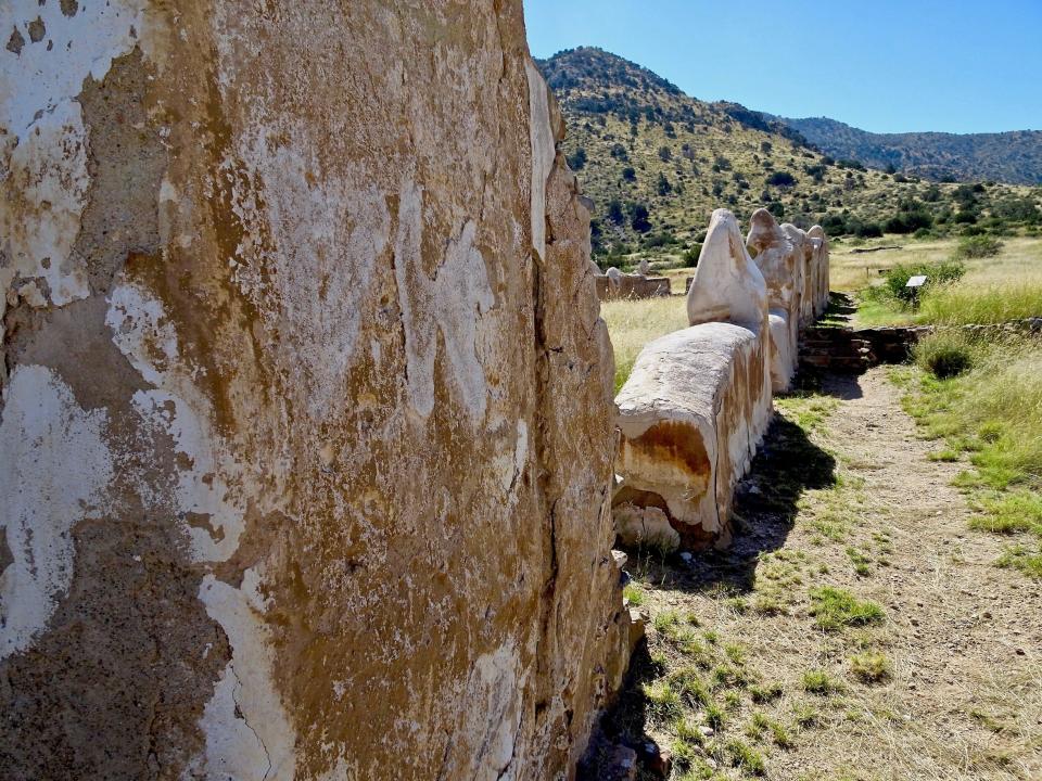
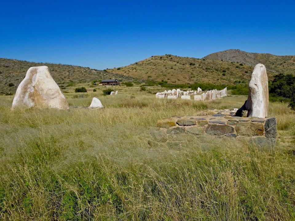
Sitting in Apache Pass separating the Chiricahua Mountains from the Dos Cabezas Mountains, Fort Bowie served as a military outpost on the Arizona frontier. It feels as lonely today as it did in the 1800s. And just as quiet. There’s nothing but bones left. Stone walls, pathways and slabs of adobe, like the fins of ancient creatures, rise out of the tall grass.
During the late 1800s, Fort Bowie was the main staging point for the U.S. Army’s conflict with the Chiricahua Apaches, led by Cochise and Geronimo. At this isolated outpost much of Arizona’s history was shaped. It’s another instance where clashes played out between an emerging nation and a proud independent people trying to preserve their land and way of life.
Why it came to a head in this secluded spot isn’t hard to figure. In Arizona, the answer to almost any question is water.
Best places I went in Arizona in 2022:Incredible hidden gems that are worth the drive
Why was Fort Bowie built at Apache Pass?
Beneath a leafy canopy, a thin trickle spills down a rock face and flows through the sand. The small gurgle is almost inaudible amid the shade of willow, walnut and velvet ash trees, but don’t be fooled. In this arid land, the splash of water echoes across the landscape like a thunderclap.
Or like cannon fire.
Apache Spring has quenched history’s thirst in southeastern Arizona while creating a crossroads of violent conflict. The spring water tumbles down a slender ravine in Apache Pass. This narrow cleft rises to an elevation above 5,000 feet and is ringed by prominent peaks like Bowie Mountain and Helen’s Dome. Desert grasses mingled with brushy chaparral dominate the lower slopes of Apache Pass with oak, juniper and piñon woodlands spread across higher ground.
For hundreds of years the area was home to the Chiricahua Apaches. Since it offered the only water source for miles around, as well as firewood and grass, Apache Pass also became a noted landmark for travelers. Spanish explorers and later Mexican settlers used Apache Pass, and it was an important stop along an emigrant trail for those heading to the California goldfields.
In 1858, the Butterfield Overland Mail Company began stagecoach service between St. Louis and San Francisco, a route that utilized Apache Pass. A station was built in the pass to take advantage of the precious spring water.
During this time there were isolated instances of violence between the Apache people and settlers. The pass and surrounding area didn’t become part of the United States until the Gadsden Purchase in 1854. For a time, Cochise and the Chiricahua Apaches managed a tenuous peace with the new arrivals. They allowed the stage line to operate largely unhindered for more than two years.
Then everything changed in the winter of 1861.
Arizona ghost-town road trip:5 former boomtowns worth the drive. Here's how to see them
What is Fort Bowie famous for? Cochise, Mickey Free and the Bascom Affair
Lt. George Bascom may have just been following orders but because of his heavy-handed and inflexible approach, he earned the distinction of forever having his name attached to the event that triggered America’s longest war. It is known simply as the Bascom Affair.
In January 1861, Felix Martinez Ward was kidnapped during an Apache raid on his family’s ranch. In February, a young inexperienced Bascom led a detachment of 54 men into Apache Pass with orders to recover Ward and all stolen livestock.
The lieutenant invited Cochise to a meeting, which quickly turned ugly when Bascom accused him of kidnapping and theft. Despite Cochise’s claims of innocence and offers to help find the boy, Bascom attempted to arrest him. Using a knife, Cochise cut through the back of the tent and escaped. The other Chiricahua Apaches, including members of Cochise’s family, were captured. The soldiers took refuge in the stone-walled Butterfield stage station.
In the following days and weeks, Cochise took captives and attempted to exchange them for his family and warriors. When his effort failed, he killed the hostages. The Army retaliated by executing the warriors in their custody. The incident sparked open warfare between whites and Chiricahua Apaches that raged for the next quarter-century.
Felix Ward had in fact been kidnapped by Apaches, but not by Cochise’s band. He was traded to the White Mountain Apaches and raised with their children to become a warrior. As an adult he became a scout and interpreter for the U.S. Army and changed his name to Mickey Free.
Tubac:Here's how to explore one of Arizona's oldest communities in a day trip
Things to see and do at Fort Bowie
The first incarnation of Fort Bowie was built in the summer of 1862, something of a crude temporary camp. A more substantial fort was constructed atop a plateau 300 yards to the southeast in 1868. These are the remains left today. A short path leads to the site of the original fort.
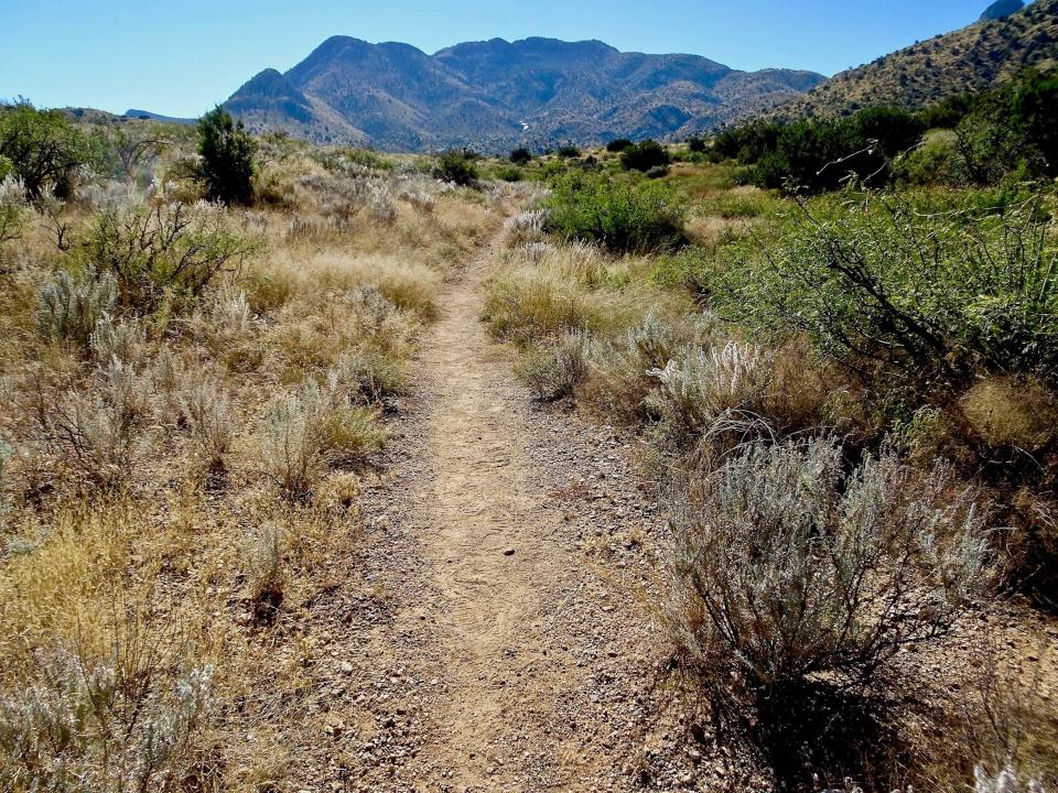
Fort Bowie National Historic Site is a walk-in park, the only one in Arizona. Visitors must take a 1.5-mile hike to enter. This helps protect natural and historical resources. It also sets the mood, allowing the sense of solitude and isolation of the frontier to seep into your consciousness. Along the way, each chapter of the story unfolds.
As you ramble across the rolling hills, the trail winds past the ruins of the Butterfield Stage Station, a recreated Apache wikiup, the post cemetery filled with grave markers, the original fort and Apache Spring, which still produces a reliable supply of water.
Along the way detailed signs provide information and locations of major incidents like the Bascom Affair and the Battle of Apache Pass, a savage fight between Cochise and 150 warriors and an advance guard of the California Column. Nothing is abstract anymore. It’s all right here. This is the ground where they stood, where they fought and died.
Soon as you climb out of the woods surrounding the spring you get your first glimpse of what remains of Fort Bowie, spread across the tablelands and ringed by rising hills.
Pathways weave among the buildings, each identified by plaques indicating its original use. Additional signs and historic photos help bring the setting to life. There’s even a photo of Geronimo and his band after their surrender in 1886. They were brought to the fort before being exiled to Florida and Alabama, thus ending the Apache Wars. Fort Bowie was abandoned in 1894.
The visitor center and its wraparound veranda lined with rocking chairs perches up the slope with picnic tables out front, an excellent spot to have lunch. The building is loaded with exhibits and artifacts adding more layers to the story. There’s also a small store stocked with books and souvenirs.
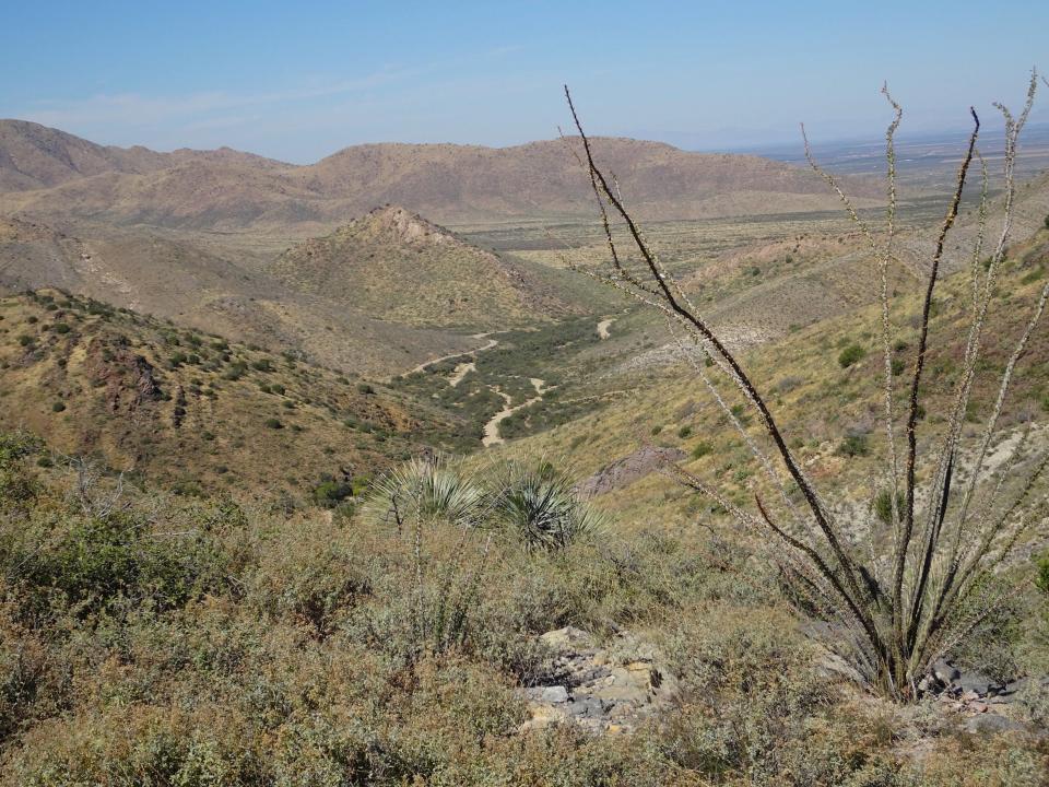
When it's time to go, you can hike back the way you came in. Another option is to take the trail behind the visitor center, which scrambles up a limestone hill known as Overlook Ridge with lovely views of the fort and valleys below.
This route doesn’t add any distance but offers more of a workout than your initial hike. But it pays for any huffing and puffing with big panoramas. It crosses the ridge, passing some informational signs and a couple of benches before descending and rejoining the entrance trail near the Butterfield Station, a half-mile from the trailhead on Apache Pass Road.
Arizona's best free attractions:21 things to see and do that don't cost a cent
How to visit Fort Bowie National Historic Site
When: Sunrise to sunset daily. The visitor center is open 8:30 a.m.-4 p.m. daily; closed on Thanksgiving and Christmas.
Where: Southeast of Willcox in southern Arizona. From Phoenix, take Interstate 10 east past Tucson to Bowie (Exit 362). Continue east on the I-10 Business Loop and turn right on Apache Pass Road. Continue 12 miles to the trailhead parking. The last mile of road is unpaved but usually manageable in a passenger vehicle. Be prepared to walk 3 miles on a dirt trail round trip to the fort and back. Access for mobility-impaired visitors can be obtained by calling the park.
Admission: Free.
Details: 520-847-2500, www.nps.gov/fobo.
Find the reporter at www.rogernaylor.com. Or follow him on Facebook at www.facebook.com/RogerNaylorinAZ or Twitter @AZRogerNaylor.
This article originally appeared on Arizona Republic: Fort Bowie in Arizona: Telling the story of the Apache Wars

