Holiday headaches likely as foul weather hits Thanksgiving travel hubs
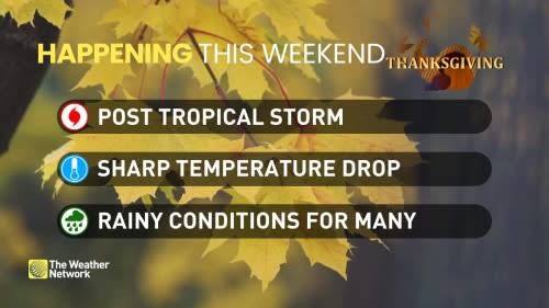
It’ll be a holiday weekend to remember for parts of Canada expecting some disruptive weather as countless folks hit the road and skies for Thanksgiving travel.
While we’ve seen some docile holiday weekends in the past, this year’s forecast heavily depends on your postal code. Some areas out west will bask in gorgeous weather while others back east deal with a flooding risk as a surge of tropical moisture flows ashore.
Visit our Complete Guide to Fall 2023 for an in-depth look at the Fall Forecast, tips to plan for it and much more!
Western Canada
Western Canada ‘wins’ the nationwide weather contest this weekend as a ridge of high pressure dominates to start the weekend.
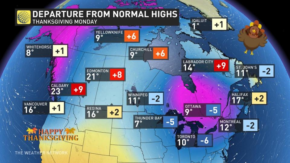
Abundant sunshine and near-seasonal temperatures will greet much of British Columbia, Alberta, and Saskatchewan for the duration. Daytime highs will climb into the upper teens and lower 20s for most communities. Parts of southern Alberta and southwestern Saskatchewan could even poke into the upper 20s.
MUST SEE: Perseverance spotted an immense 2 kilometre-high dust devil on Mars
We’ll see things begin to change toward Thanksgiving Day on Monday, though, as a system pushes into B.C.’s South Coast by the start of the week. Heavy rain will develop across Vancouver Island and the Lower Mainland during the day Monday, possibly making for slick travel and nixing the chance for an after-dinner stroll.
Ontario
The eastern half of the country will experience a very different weekend courtesy of a lobe of the polar vortex. This upper-level low will drag some of the chilliest air on the planet south out of northern Canada.
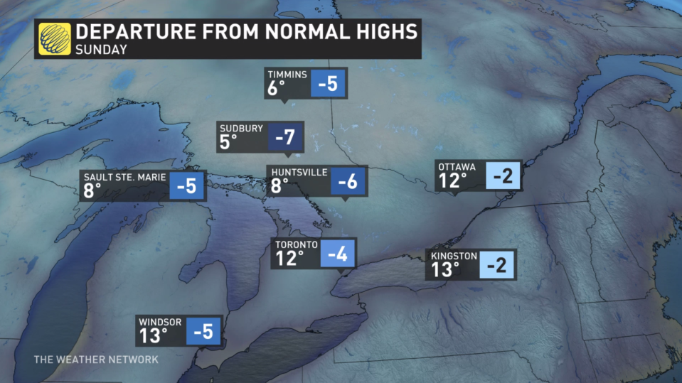
Ontario will see the coldest air on Sunday and Monday, with highs in Toronto barely cracking the double-digits. Northwestern Ontario will remain in the lower single digits—and that’s before you factor in the wind chill.
GET THE LATEST: Wet, windy weekend in the Maritimes as Philippe washes ashore
Lake-effect rain showers are possible throughout the weekend along the shores of Lake Huron and Georgian Bay. This same instability could lead to a risk for funnel clouds and waterspouts over the lakes, so keep an eye to the skies if you’re in the region this weekend.
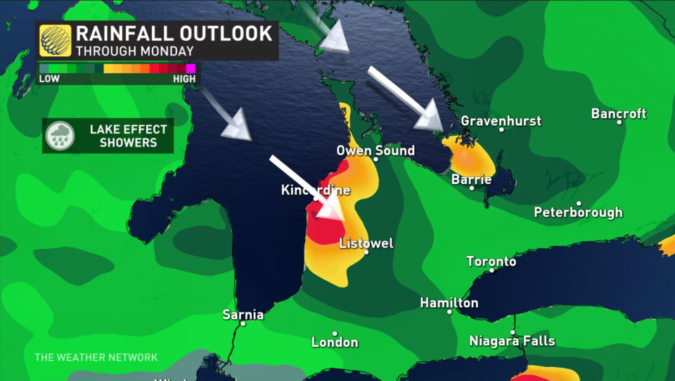
Temperatures will be cold enough for snow to appear in the forecast for folks in northeastern Ontario. Warm surface temperatures will keep much of the snow from accumulating, so stay tuned to The Weather Network for the latest on amounts across the region.
Quebec and the Maritimes
We’re monitoring the progress of post-tropical storm Philippe as it gradually makes its way toward New England and Eastern Canada over the next couple of days.
RELATED: Quebec faces holiday weekend washout, localized flood risk
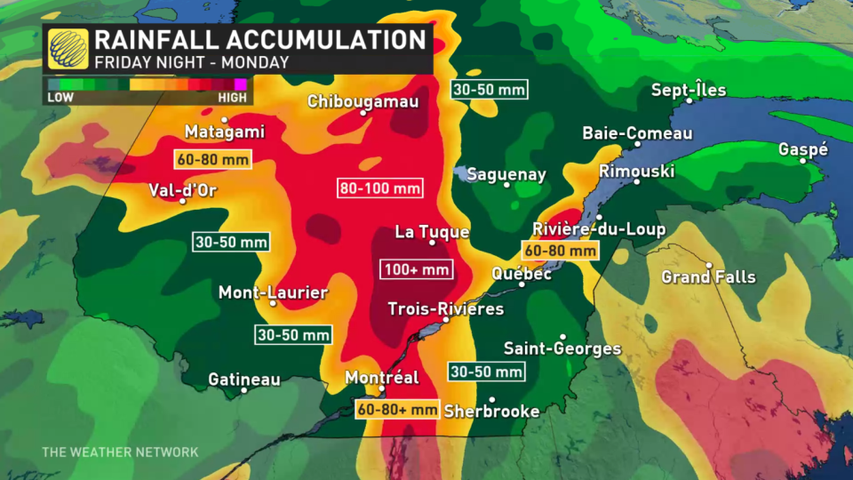
Heavy rain in Quebec that began on Friday will continue into the weekend, fuelled in part by the arrival of those tropical remnants. Some communities could see 50-100+ mm of rain through early next week, leading to the risk for localized flooding.
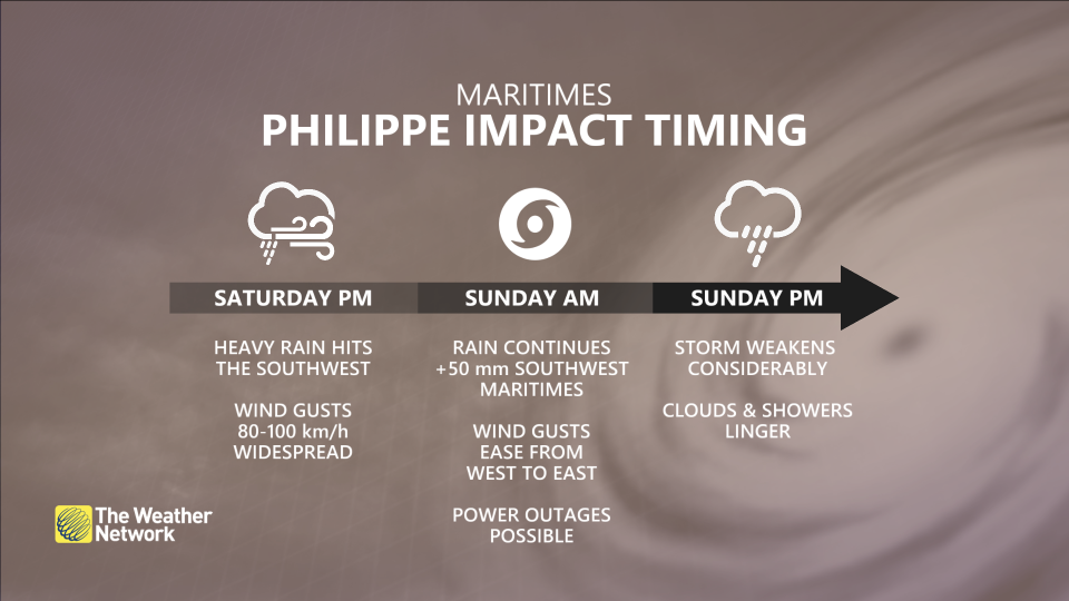
The Maritimes will deal with the remnants of Philippe on Saturday. Widespread wind gusts of 80-100 km/h are expected throughout the region, with rainfall totals of 30-50 mm possible in southwestern portions of Nova Scotia and New Brunswick.
While Philippe should be much less severe than Lee a few weeks back, the combination of rain and gusty winds could lead to localized power outages.
Header image created using photos from Pixabay.
Stay tuned to The Weather Network for forecast updates across Canada.

