'Homebrew' tropical system could develop along US East Coast


In the wake of Hurricane Lee, AccuWeather meteorologists will be keeping a close eye on near-coast Atlantic waters in the area from northeastern Florida to North Carolina late this week to this weekend as this zone could yield a tropical system, which could unleash rain and gusty winds along a significant part of the Eastern Seaboard.
"Stalled fronts along the southeastern coast of the United States are one way a 'homebrew' tropical system can form," AccuWeather Chief On-Air Meteorologist Bernie Rayno said.
Energy in the atmosphere is highly likely to produce an area of low pressure along a stalled front toward the end of the week. The Gulf Stream, which is a current that originates from the Caribbean, transports warm water along much of the East Coast. Water temperatures in this zone are currently well into the 80s and well above the minimum threshold needed for tropical development to take place.
 |
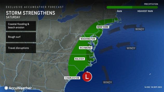
AccuWeather forecasters say the question is whether the low-pressure area will have enough time to develop fully into a tropical system before it is pushed inland over the Carolinas this weekend.
"There will be stiff southerly breezes [wind shear] a few thousand miles above the surface in this zone," AccuWeather Senior Meteorologist Adam Douty said. "Not only might the wind shear inhibit full tropical development, it may also push the system onshore swiftly and essentially end the development process."
The wind shear is likely to prevent strengthening into a hurricane, Rayno said.
Factoring in all atmospheric conditions that will favor vs. hinder development, AccuWeather meteorologists believe there is a medium chance for a tropical depression and/or storm to form along the southeast U.S. coast from Friday to Saturday.
 |
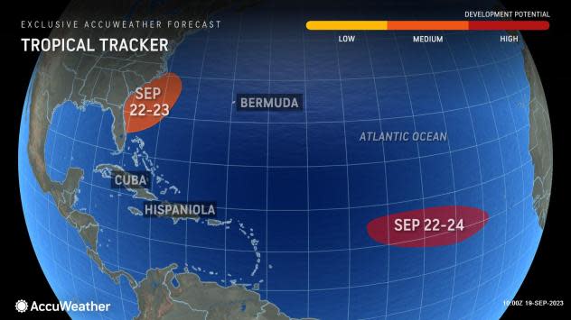
The next two names on the list of tropical storms for the 2023 Atlantic hurricane season are Ophelia and Phillippe, as there is also another area thousands of miles out in the basin that could develop around the same time as the near-U.S. system.
"It is possible that even if the center of the storm manages to linger right along the coast, heavy rain and thunderstorms associated with the system will be forced northward along the Carolina and mid-Atlantic coast from Friday to Saturday," Douty said.
 |
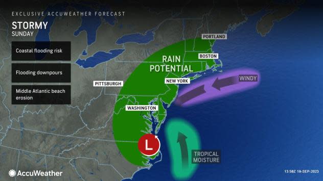
The rain may continue to advance into upstate New York and part of New England from Saturday night to Sunday.
There is also the possibility that a storm system rolling in from the Midwest could pull in moisture from the budding Atlantic system, further enhancing rainfall and perhaps spreading wet weather as far west as the central Appalachians.
 |
Should a tropical system or even a hybrid system take shape, if it manages to take on some tropical characteristics, severe thunderstorms could develop and spawn a couple of tornadoes or waterspouts near the coast.
With the risk of heavy rain will come the possibility of urban and flash flooding, travel disruptions and hindrances to outdoor plans such as ball games, weddings or family gatherings.
In general, the period from Friday to Sunday could be quite stormy along the coast from the Carolinas to southern New England due to stiff winds that will kick up seas and create strong rip currents as well as the risk of heavy rain and gusty thunderstorms, Douty said. So, yet another tropical system could spoil some weekend fun at the beach.
AccuWeather will continue to monitor this near-U.S. zone, Hurricane Nigel and other areas of potential tropical development in the Atlantic in the coming days.
 |
"After a tropical disturbance [tropical wave] moves away from Africa and into the central Atlantic, there is the likelihood for a tropical system to form," Rayno said, "However, that system is likely to stay away from the U.S."
The Atlantic hurricane season continues through the end of November.
Want next-level safety, ad-free? Unlock advanced, hyperlocal severe weather alerts when you subscribe to Premium+ on the AccuWeather app. AccuWeather Alerts™ are prompted by our expert meteorologists who monitor and analyze dangerous weather risks 24/7 to keep you and your family safer.
