Update: Tornado watch and high winds continue in Myrtle Beach area. Waterspout spotted
Horry County remains under a tornado watch until 6 p.m. Tuesday, according to the National Weather Service in Wilmington, North Carolina.
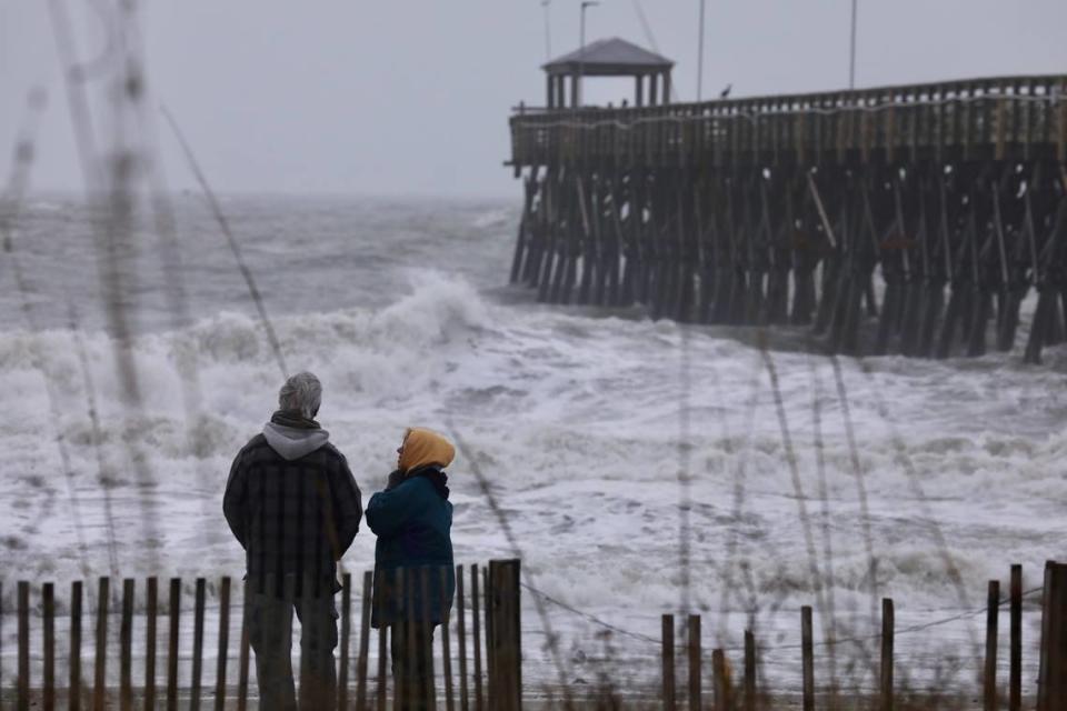
During Tuesday’s winter storm, tornado warnings were issued for the Myrtle Beach area, including Conway, Socastee and Murrells Inlet, and North Myrtle Beach and Little River.
There have been no confirmed tornadoes, according to the NWS. However, someone did report a waterspout off the coast of Windy Hill Beach in North Myrtle Beach, said Rachel Zouzias, a meteorologist with the National Weather Service in Wilmington. A waterspout is a tornado but on the water.
Zouzias said the NWS won’t know until later if a tornado actually touched down.
Tornado Warning including Myrtle Beach SC, Socastee SC and Conway SC until 2:45 PM EST pic.twitter.com/1YhzLyi09l
— NWS Wilmington, NC (@NWSWilmingtonNC) January 9, 2024
If a tornado is eminent, residents are urged to take shelter and stay away from windows, doors and outside walls, officials said.
The Weather Channel began calling Tuesday’s storm Winter Storm Finn. Finn is expected to move off the coast by 10 p.m., according to the NWS.
There have been heavy winds all day Tuesday and around 1 to 1.5 inches of rainfall. There are low levels of flash flooding and a chance of minor coastal flooding around high tide this evening.
The NWS also said there will be hazardous marine conditions until Tuesday night with gusts of up to 55 knots and seas at 12 to 15 feet. A storm warning is in effect on the coastal waters until midnight.
A tornado watch has been issued for parts of Florida, Georgia, North Carolina and South Carolina until 6 PM EST pic.twitter.com/pEJCoxOmdZ
— NWS Wilmington, NC (@NWSWilmingtonNC) January 9, 2024
A high wind warning went into effect at 10 a.m. Tuesday for coastal areas of Horry County, according to the Horry County Emergency Management. Wind gusts of up to 60 mph are possible at times and do not include potentially stronger winds within thunderstorms or tornadoes, the agency said in a social media post.
High profile vehicles, such as a car, truck or SUV that sits higher off the ground than a standard vehicle, should use caution, especially on bridges and overpasses, officials warn.
Bob Bright, a meteorologist with the NWS in Wilmington, said Sunday that the wind is the main concern. The high wind could could damage trees and power lines, causing power outages, which happened in Conway and Socastee Tuesday afternoon.
“Flooding won’t have as big of an impact as the December storm,” Bright said. “Winds could be stronger for longer.”
Several school districts and government offices, including Horry County Schools, which has gone to an eLearning Day, and Horry County government, have already announced closings Tuesday ahead of the storm.
Staying safe
The South Carolina Emergency Management Division is advising that all outdoor furniture, lawn decorations and other items should be brought inside. Severe winds could cause them to go flying and become “dangerous projectiles.”
The department also told residents to make sure they have non-perishable foods, water and flashlights in case the power goes out. They also recommended people to charge devices.
If there is a tornado, head to the bottom floor of the building you are in and stay away from windows, doors and outside walls. If you are in a vehicle or mobile home, try to find shelter. If that’s not possible, it is recommended to lay on the ground in a ditch with your hands over your head.
The NWS advises people to not walk or drive through floodwater. At 6 inches, floodwater can knock people down and at 12 inches, rushing floodwater can carry away a car. If you must leave, drive slowly with your headlights on and leave twice as much space as normal in between your car and the one in front of you, according to the Automobile Association.
This is a developing story. Check back with The Sun News for storm updates.

