An hour-by-hour look at the holiday travel-snarling, monster storm headed to pound NJ
- Oops!Something went wrong.Please try again later.
UPDATE 9:52 P.M.: Gov. Phil Murphy tweeted Thursday night that all state government offices would be closed Friday due to potential hazardous road conditions.
Nevertheless, state employees would still be available to handle essential business working from home, Murphy said.
"We strongly encourage everyone to stay off the roads and be safe," the governor tweeted.
Due to the forecast calling for hazardous road conditions, state offices will be closed tomorrow, Friday, December 23. State employees will still be available to handle essential business via telework.
We strongly encourage everyone to stay off the roads and be safe.— Governor Phil Murphy (@GovMurphy) December 23, 2022
A sprawling monster of a winter storm was lunging toward New Jersey Thursday and is expected to bring a bevy of threats to the state’s doorstep amid one of the busiest travel times of the year.
High winds, heavy rain, coastal flooding and some snow are all on tap for the Garden State Thursday and Friday. They lead an unusually strong cold front that will cause a 30- to 40-degree drop in temperature and bring the threat of a “flash freeze” Friday afternoon and evening.
Friday's commute could be particularly hazardous, meteorologists said.
That afternoon and evening, “anything wet on the roadways is going to freeze," said Steve DiMartino, founder of the weather forecasting service NY NJ PA Weather.

Moderate coastal flooding is also expected to impact parts of Middlesex and Monmouth counties, particularly during Friday morning's high tide, said Joe DeSilva, a meteorologist at the National Weather Service in Mount Holly.
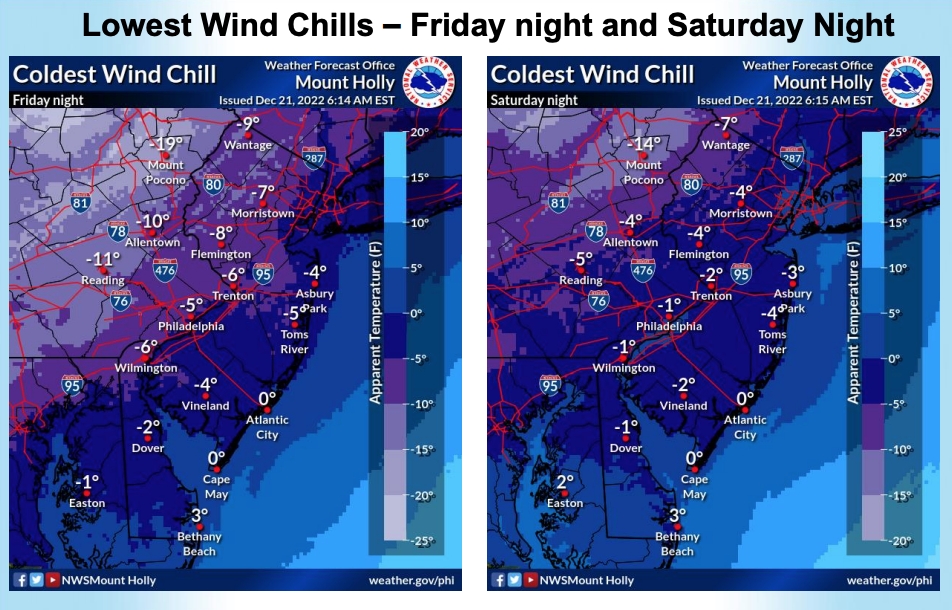
The storm is likely to make conditions dangerous across much of the state, as the coming cold front will drive temperatures from the 40s and 50s down into the teens and single digits, according to meteorologists. Combined with wind gusts in the 40- to 50-mph range, wind chills will be below zero across much of New Jersey, according to the National Weather Service.
The storm and its trailing Arctic front will have impacts across the country, and will arrive just as many are embarking on holiday travel plans. AAA estimates more than 112 million people will travel 50 miles or more between Dec. 23 and January.
Here's what to expect, and when:
Thursday
Northern New Jersey faces the storm's start with a chance of snow and freezing rain before 10 a.m. However, as temperatures warm into the 40s, rain will wash away any wintery accumulation, according to the weather service.
In central and southern New Jersey, rain is not likely to move into the area until the afternoon. Temperatures here will rise into the low 50s.
Warm temperatures and heavy rain will dominate the storm's first phase through much of Thursday as it pulls warmth and moisture from the southern United States across New Jersey, DiMartino said.
Rain will intensify across central and southern New Jersey and winds will increase to 5 to 15 mph through the afternoon. Winds will start to build toward the evening as the rain becomes heavier across the state, according to the weather service.
11:30 p.m., Thursday: Rain intensifies
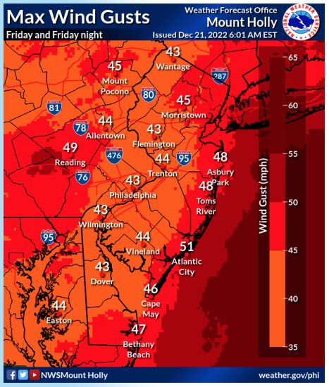
Strong sustained winds of 20 to 30 mph and intense, heavy rain will last through Thursday evening and night, with gusts in the 40-mph range, according to meteorologists.
The wind "is going to reach an apex as you head towards midnight," DiMartino said.
Anyone headed to the New York Jets game, scheduled for 8:15 p.m. at MetLife Stadium in East Rutherford, should be prepared, he said.
"it's just going to be a complete mess with intense rainfall, strong winds," he added.
Residents should secure garbage cans, holiday decorations and any outdoor items that could be tossed in the wind gusts, DiMartino said.
7 a.m., Friday: Coastal flooding begins
Residents of Monmouth and Middlesex counties should brace for moderate coastal flooding with the morning high tide. Waters could be more than 2 feet higher than usual around 7 and 8 a.m. in places like Sandy Hook and Arthur Kill in Perth Amboy, according to the National Weather Service.
Around the rest of the New Jersey coastline and along the Delaware Bay, flooding is more like to be minor, said DeSilva, of the National Weather Service.
Gale force winds will batter the coasts and gusts could reach speeds of up to 45 knots, according to the weather service.
Inland, wind gusts will reach speeds in the upper 40- and 50-mph range, which could lead to isolated power outages from downed trees and wires, according to the weather service.
Heavy rain and strong winds will continue through the morning. Temperatures will remain in the 40s and lower 50s ahead of an arctic cold front.
10 a.m., Friday: The Arctic front moves in
Friday morning and afternoon, the second, colder phase of the storm system will move across New Jersey, DiMartino said.
"That arctic front is going to start to push in around 10 a.m. and will march through the region from 10 a.m. to 4 p.m.," he said. "This arctic cold front, initially, is going to produce very heavy rainfall and strong wind. It's almost like a line of strong thunderstorms."
Thunder is possible across much of New Jersey as the cold front moves through, according to the National Weather Service.
1 p.m., Friday: Huge temperature drops
In northern New Jersey, rain will transition to snow sometime between 1 and 4 p.m., according to the National Weather Service. In central and southern New Jersey, the transition is more likely after 4 p.m.
This transition will likely bring a sudden temperature drop of around 30 degrees in as little as 90 minutes, DiMartino said. Temperatures that reached the 40s and 50s Friday afternoon will begin to plummet toward the 20s and 30s, he said.
"That's going to allow the rain to rapidly change over to snow," DiMartino said.
The temperature change "is going to come in like a blitz," he said. "It's gonna switch on you. If you're outside, you're going to feel your temperatures just crash on you."
Coastal New Jersey could see a trace amount to as much as two inches, while northwestern areas of the state could see between an inch or three of snow in the transition, he said.
The National Weather Service expects almost none of that snow to accumulate, but rather to be followed by isolated snow showers, predominantly across north and western parts of New Jersey.
5 p.m., Friday: A frozen commute begins
Friday's plunging temperatures will lead freezing wet surfaces in the later half of the day, meteorologists said.
"Anything wet on the roadways is going to freeze," DiMartino said.
A narrow squall line could develop with the cold front and drive wind gusts up to 60 mph, according to the National Weather Service. Drivers are advised to leave additional travel time to reach their destinations.
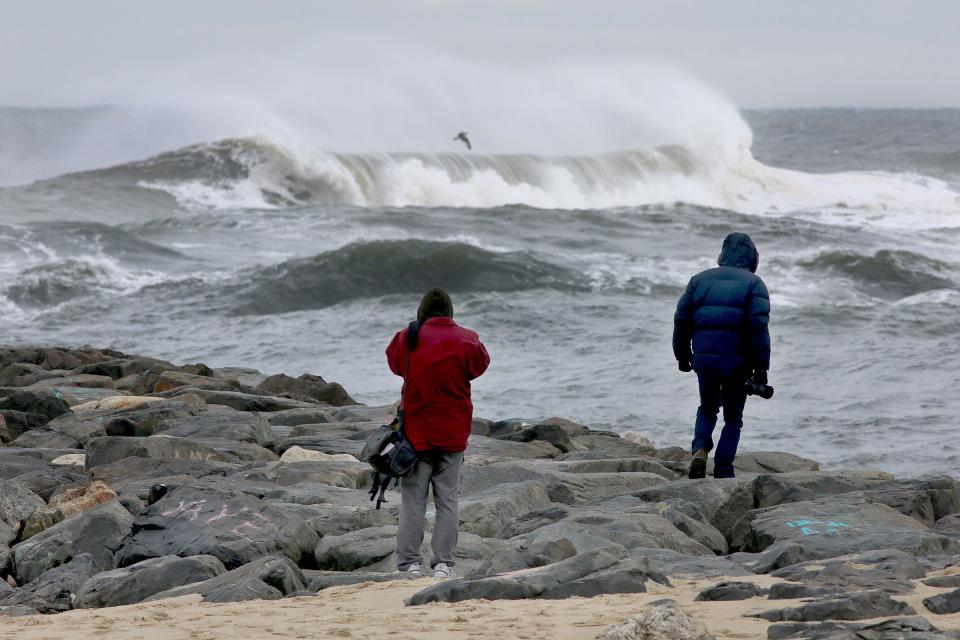
Along the ocean, wave heights could reach 9 to 14 feet under the windy conditions, according to meteorologists.
8 p.m. Friday: The deep freeze
Wind gusts in the 40- to 50-mph range will continue and, combined with sub-freezing temperatures, drive wind chills down to near or below zero as the night progresses.
In northern New Jersey, temperatures will dip into the single digits. Southern areas of the state will see overnight lows in the lower teens.
By the evening, most of the rain and snow will be over, but conditions will remain dangerously cold and windy.

Saturday and Sunday
Sunny skies return to New Jersey, but will not warm temperatures out of the upper teens in northern New Jersey. Southern and central parts of the state will reach highs in the mid-20s. Unusually cold and breezy conditions will last through the day.
Overnight lows will drop back into the teens and single digits across the state, according to the weather service.
Sunday could be a record-setting cold Christmas, according to the National Weather Service. Like Saturday, temperatures will not climb out of the 20s under sunny skies.
Continue to look at a high impact winter storm event for Thursday into Friday followed by dangerously cold wind chills for our area.
First, we are looking at substantial rainfall with this event. Latest rainfall forecast from local NWS offices. pic.twitter.com/YoOnfaC88S— Gary Szatkowski (@GarySzatkowski) December 21, 2022
Amanda Oglesby is an Ocean County native who covers Brick, Barnegat and Lacey townships as well as the environment. She has worked for the Press for more than a decade. Reach her at @OglesbyAPP, aoglesby@gannettnj.com or 732-557-5701.
This article originally appeared on Asbury Park Press: NJ weather: Storm to bring plunging temps, high winds, freezing roads

