Louisiana at risk for severe thunderstorms with tornadoes, flash flooding into Thursday night


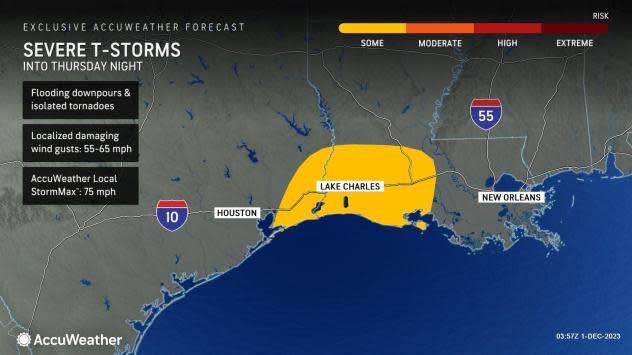

A round of late-season severe thunderstorms, some potentially spawning tornadoes and unleashing flooding downpours, is expected to impact portions of Texas and Louisiana into Thursday night, warn AccuWeather meteorologists.
Lake Charles, Louisiana, is included in the risk zone, which extends from far southeastern Texas through central Louisiana. Residents and businesses in this area will need to stay weather-aware into Thursday night, as storms develop and move through.
"A significant amount of energy and spin in the atmosphere will combine to produce the threat of severe weather across southeastern Texas and Louisiana," said AccuWeather Senior Meteorologist Adam Douty.
 |
The area with the highest risk for tornadoes includes the city of Lake Charles, Louisiana. Damaging wind gusts and hail are also possible with storms that track over these areas.
The storms, driven by a developing area of low pressure over the southern Plains and a surge of moisture from the Gulf of Mexico, are expected to form and move slowly from south to north. Because of the degree of energy and "spin" available in the atmosphere, as Douty added the threat of severe weather and even tornadoes will continue into Thursday night, when storms traditionally begin to weaken.
 |
On a typical day in late November, there is about a 0.20% (or 1-in-500) chance of a tornado within 25 miles of any given point in the Greater Houston area, according to a Storm Prediction Center climatology database.
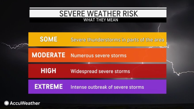
When there is an elevated risk of twisters, those in the risk area should have a plan in case a tornado warning is issued. That warning, communicated through media sources, apps (including the free AccuWeather app) and wireless emergency alerts, means a tornado has formed or was indicated on radar. When that happens, those in the warned area should seek shelter in a significant structure and go to the lowest interior room in the building.
 |
Besides a risk for tornadoes, a few storms can also produce hail and damaging wind gusts in the range of 55-65 mph. The AccuWeather Local StormMax™ for wind is 75 mph, equivalent to that of a Category 1 hurricane.
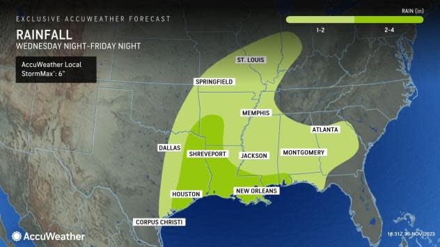
Perhaps the most widely experienced effect of the storms into Thursday night and even early Friday near the Gulf Coast will be the threat of flooding downpours, say AccuWeather forecasters.
"Most of southeastern Texas can also endure repeated downpours which will lead to a threat of flooding," Douty added. "In urban areas around Houston, ponding on roads and flash flooding in low-lying areas could become a more significant concern, leading to travel delays."
The threat of continuous downpours will lead to widespread rainfall of 2-4 inches across the severe weather risk area, as well as north into the Arklatex and east through the rest of Louisiana and southern Mississippi and Alabama later on Friday and Friday night. Some of that rain can fall in just an hour or two.
 |
For those traveling along portions of Interstates 10, 20, 30 and 35 into Thursday night, as well as any low-lying secondary road, motorists should remember the adage "turn around; don't drown" when they encounter water covering the roadway.
Concerns over flooding and severe weather will put a damper on what could actually be beneficial rain for a portion of the area expected to see downpours to end the week. According to the latest U.S. Drought Monitor released on Thursday morning, a staggering 87% of Louisiana is in extreme or exceptional drought, the highest two categories in the report. Exceptional drought conditions were also present in portions of neighboring far southeastern Texas and Mississippi.
Want next-level safety, ad-free? Unlock advanced, hyperlocal severe weather alerts when you subscribe to Premium+ on the AccuWeather app. AccuWeather Alerts™ are prompted by our expert meteorologists who monitor and analyze dangerous weather risks 24/7 to keep you and your family safer.
