Baseball-sized hail, winds over 60 mph, isolated tornadoes possible across Central Florida
April is living up to its name in Florida and there's no end in sight from some storms that have been severe.
Heavy rain and thunderstorms will continue to affect much of the Sunshine State the remainder of the week and into the weekend as a combination of several different cold fronts and low-pressure systems move either through the state or into the Gulf of Mexico.
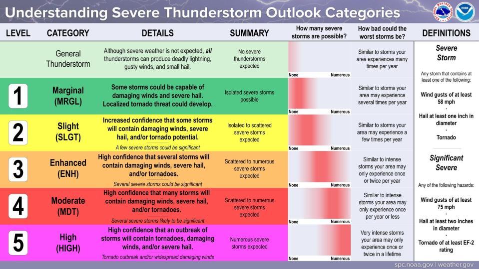
By 9 a.m., the Storm Prediction Center said much Central Florida is now under an enhanced risk for severe weather, up from the "slight" risk earlier.
What's that mean?
An enhanced risk means scattered to numerous severe storms are expected and that forecasters have high confidence that several storms will contain damaging winds, severe hail and/or tornadoes.
A slight risk means isolated to scattered severe storms are expected and that forecasters have increased confidence that some storms will contain damaging winds, severe hail and/or the potential for tornado.
On the bright side, drier and slightly cooler conditions may return for the first week of May, according to the Florida Public Radio Emergency Network.
Florida facing baseball-sized hail, damaging winds, threat of tornadoes
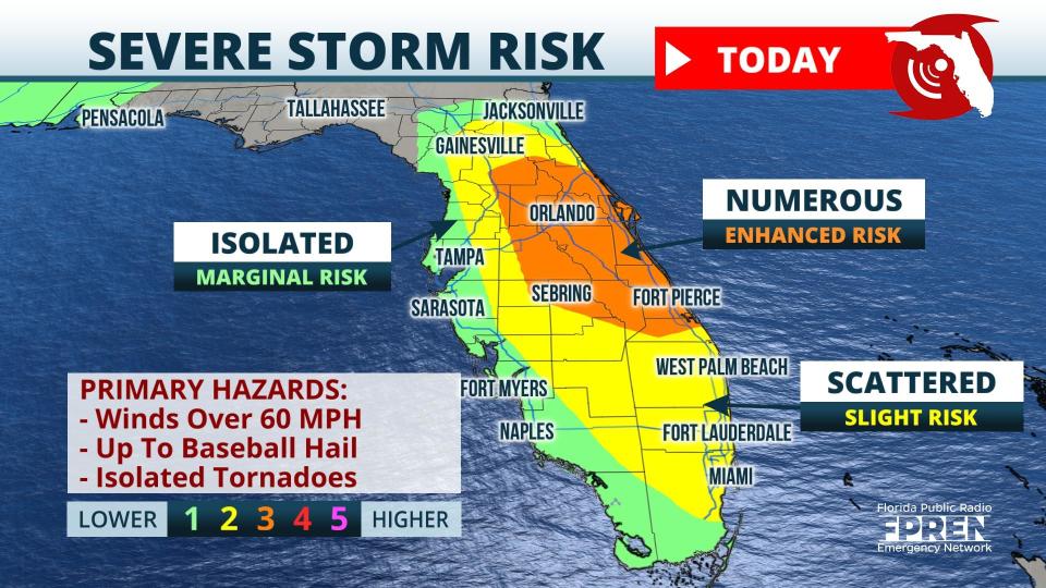
Very large hail, up to the size of baseballs, and winds of more than 60 mph are the main threats, according to the Florida Public Radio Emergency Network.
Isolated, brief tornadoes are also possible, especially near the Atlantic Coast. Flash flooding will be a concern with torrential rain at times. Some areas may pick up over 2 inches in a very short time.
The greatest storm coverage is expected from Ocala through Orlando and south into Fort Pierce.
Damaging thunderstorms are expected across interior and eastern parts of Florida today. Large hail and wind gusts in excess of 60 mph will be possible, according to the Florida Public Radio Emergency Network.
The National Weather Service in Melbourne warned residents earlier this morning some hail could be larger than 2 inches in diameter. Downpours of one to three inches are possible.
Thursday, the severe risk shifts into the Panhandle then returns to the Peninsula on Friday.
Series of cold fronts affecting Florida weather
A slow-moving cold front earlier this week brought some storms to Central and South Florida, which was bombarded by a historic rain event a couple weeks ago. Fort Lauderdale was hit by 25.95 inches of rain over 24 hours, while other areas saw 20 inches in six hours, according to AccuWeather.
'Once in every 1,000-2,000 years': Storm swamps Fort Lauderdale with 25 inches of rain
2 feet of rain! Fort Lauderdale saw 2 feet of rain in a day. How on Earth is that even possible?
More cold fronts are expected to move through Florida over the weekend, bringing more rain and isolated to scattered severe storms.
Weather watches and warnings issued for your area
If you can't see any local weather warnings here, you'll need to open this story in a web browser.
Shortly after 2 p.m., a severe thunderstorm watch was issued for Brevard, Broward, DeSoto, Glades, Hardee, Hendry, Highlands, Indian River, Lake, Martin, Miami-Dade, Okeechobee, Orange, Osceola, Palm Beach, Polk, St. Lucie, Seminole and Sumter County until 9 p.m.
Weather alerts issued in Florida
Rolling storm damage reports in Florida
As storms strike, this interactive map is your guide to impacts and damage reports coming into National Weather Service stations nationwide. Did a tornado strike? How big was that hail? How many trees were downed? Is a road closed because of flooding? Scroll over each icon for answers and to see reports from the strike zone.
Here is the forecast across Florida, along with the latest radar images to keep you informed.
Weather radar and forecast for Pensacola

Forecast:
Wednesday: Partly sunny, with a high near 78. Southeast wind 5 to 10 mph.
Thursday: A chance of showers and thunderstorms, then showers and possibly a thunderstorm after 1 p.m. High near 76. South wind 10 to 15 mph, with gusts as high as 25 mph. Chance of precipitation is 80%. New rainfall amounts between 1 and 2 inches possible.
Friday: A 50 percent chance of showers and thunderstorms. Partly sunny, with a high near 79. Southwest wind around 10 mph.
Saturday: A 50 percent chance of showers and thunderstorms. Partly sunny, with a high near 79. East wind 5 to 15 mph becoming south in the afternoon. Winds could gust as high as 20 mph.
Sunday: A 30 percent chance of showers and thunderstorms, mainly before 1pm. Partly sunny, with a high near 76. West wind around 15 mph, with gusts as high as 25 mph.
Follow National Weather Service Mobile on Twitter
Weather radar and forecast for Tallahassee

Forecast:
Wednesday: A 20 percent chance of showers and thunderstorms after 2 p.m. Mostly sunny, with a high near 86. East wind 5 to 10 mph.
Thursday: A 50 percent chance of showers and thunderstorms after 2 p.m. Mostly cloudy, with a high near 84. South southeast wind 5 to 10 mph. New rainfall amounts of less than a tenth of an inch, except higher amounts possible in thunderstorms.
Friday: Showers likely and possibly a thunderstorm. Mostly cloudy, with a high near 82. South southwest wind 10 to 15 mph. Chance of precipitation is 70%.
Saturday: A chance of showers and thunderstorms, then showers likely and possibly a thunderstorm after 2 p.m. Partly sunny, with a high near 86. Chance of precipitation is 60%.
Sunday: Showers likely and possibly a thunderstorm before 2 p.m., then a chance of showers and thunderstorms after 2 p.m. Partly sunny, with a high near 79. Breezy. Chance of precipitation is 60%.
Follow the National Weather Service Tallahassee on Twitter
Weather radar and forecast for Jacksonville

Forecast:
Wednesday: A 30 percent chance of showers and thunderstorms, mainly between 3 p.m. and 4 p.m. Mostly sunny, with a high near 81. East wind 5 to 13 mph.
Thursday: A 30 percent chance of showers and thunderstorms, mainly after 4 p.m. Mostly sunny, with a high near 83. Breezy, with an east wind 6 to 15 mph.
Friday: A chance of showers and thunderstorms, then showers likely and possibly a thunderstorm after 2 p.m. Cloudy, with a high near 83. Breezy, with a south wind 10 to 17 mph. Chance of precipitation is 60%.
Saturday: A 40 percent chance of showers and thunderstorms. Mostly sunny, with a high near 89.
Saturday Night: A 50 percent chance of showers and thunderstorms. Mostly cloudy, with a low around 67.
Sunday: Showers likely and possibly a thunderstorm. Mostly cloudy, with a high near 82. Breezy. Chance of precipitation is 70%.
Follow the National Weather Service Jacksonville on Twitter
Weather radar and forecast for Daytona Beach
Forecast:
Wednesday: A slight chance of showers between 8 a.m. and 11 a.m., then a chance of showers and thunderstorms after 11 a.m. Some storms could be severe, with large hail. Partly sunny, with a high near 80. East northeast wind 5 to 10 mph. Chance of precipitation is 40%.
Thursday: A 30 percent chance of showers and thunderstorms after 2 p.m. Mostly sunny, with a high near 80. East wind 5 to 10 mph.
Friday: Showers and possibly a thunderstorm. High near 84. South wind 10 to 15 mph. Chance of precipitation is 80%.
Saturday: Showers likely and possibly a thunderstorm. Mostly sunny, with a high near 84. West southwest wind around 10 mph. Chance of precipitation is 60%.
Sunday: Showers likely and possibly a thunderstorm. Partly sunny, with a high near 83. South wind around 15 mph, with gusts as high as 25 mph. Chance of precipitation is 60%.
Follow the National Weather Service Melbourne on Twitter
Weather radar and forecast for Melbourne
Forecast:
Wednesday: A chance of showers and thunderstorms before 2 p.m., then showers likely and possibly a thunderstorm between 2 p.m. and 5 p.m., then a chance of showers and thunderstorms after 5 p.m. Some storms could be severe, with large hail. Partly sunny, with a high near 82. East northeast wind 5 to 10 mph. Chance of precipitation is 60%. New rainfall amounts of less than a tenth of an inch, except higher amounts possible in thunderstorms.
Thursday: A 30 percent chance of showers and thunderstorms after 2pm. Mostly sunny, with a high near 83. East southeast wind 5 to 10 mph.
Friday: Showers likely and possibly a thunderstorm. Mostly cloudy, with a high near 87. South wind around 10 mph. Chance of precipitation is 70%.
Saturday: Showers likely and possibly a thunderstorm. Mostly sunny, with a high near 86. Southwest wind around 10 mph. Chance of precipitation is 60%.
Sunday: Showers likely and possibly a thunderstorm. Partly sunny, with a high near 87. South wind around 15 mph, with gusts as high as 25 mph. Chance of precipitation is 60%.
Follow the National Weather Service Melbourne on Twitter
Weather radar and forecast for Port St. Lucie
Forecast:
Today: A slight chance of showers before 11 a.m., then a chance of showers and thunderstorms between 11 a.m. and 2 p.m., then showers likely and possibly a thunderstorm after 2 p.m. Some storms could be severe, with large hail. Partly sunny, with a high near 84. Light and variable wind becoming east 5 to 10 mph in the morning. Chance of precipitation is 60%. New rainfall amounts of less than a tenth of an inch, except higher amounts possible in thunderstorms.
Thursday: A 30 percent chance of showers and thunderstorms after 2 p.m. Mostly sunny, with a high near 84. East wind 5 to 10 mph.
Friday: A chance of showers and thunderstorms, then showers likely and possibly a thunderstorm after 8 a.m. Partly sunny, with a high near 88. South wind around 10 mph. Chance of precipitation is 60%.
Saturday: A 50 percent chance of showers and thunderstorms. Mostly sunny, with a high near 87. Southwest wind 5 to 10 mph.
Sunday: A 50 percent chance of showers and thunderstorms. Partly sunny, with a high near 88. Windy, with a south wind 10 to 20 mph, with gusts as high as 25 mph.
Follow the National Weather Service Melbourne on Twitter
Weather radar and forecast for West Palm Beach

Forecast:
Wednesday: A slight chance of showers before 11 a.m., then a chance of showers and thunderstorms between 11 a.m. and 2 p.m., then showers likely and possibly a thunderstorm after 2 p.m. Some storms could be severe, with large hail. Partly sunny, with a high near 84. Light and variable wind becoming east 5 to 10 mph in the morning. Chance of precipitation is 60%. New rainfall amounts of less than a tenth of an inch, except higher amounts possible in thunderstorms.
Thursday: A 30 percent chance of showers and thunderstorms after 2pm. Mostly sunny, with a high near 84. East wind 5 to 10 mph.
Friday: A chance of showers and thunderstorms, then showers likely and possibly a thunderstorm after 8am. Partly sunny, with a high near 88. South wind around 10 mph. Chance of precipitation is 60%.
Saturday: A 50 percent chance of showers and thunderstorms. Mostly sunny, with a high near 87. Southwest wind 5 to 10 mph.
Sunday: A 50 percent chance of showers and thunderstorms. Partly sunny, with a high near 88. Windy, with a south wind 10 to 20 mph, with gusts as high as 25 mph.
Follow the National Weather Service Miami on Twitter
Weather radar and forecast for Naples
Forecast:
Wednesday: A 20 percent chance of showers and thunderstorms after 2 p.m. Some of the storms could produce heavy rain. Sunny, with a high near 84. East wind 5 to 10 mph becoming west in the afternoon.
Thursday: A 20 percent chance of showers and thunderstorms after 2 p.m. Mostly sunny, with a high near 86. East wind 6 to 10 mph becoming south in the afternoon.
Friday: A slight chance of showers, then a chance of showers and thunderstorms after 11 a.m. Partly sunny, with a high near 86. Southeast wind 8 to 14 mph, with gusts as high as 18 mph. Chance of precipitation is 30%.
Saturday: A 30 percent chance of showers and thunderstorms, mainly after 2 p.m. Mostly sunny, with a high near 86. Southwest wind 8 to 13 mph.
Sunday: A chance of showers, with thunderstorms also possible after 2 p.m. Mostly sunny, with a high near 86. Windy, with a south wind 15 to 21 mph, with gusts as high as 26 mph. Chance of precipitation is 40%.
Follow the National Weather Service Miami on Twitter
Weather radar and forecast for Fort Myers

Forecast:
Wednesday: Scattered showers and thunderstorms after 2 p.m. Mostly sunny, with a high near 86. East wind 5 to 7 mph becoming west southwest in the afternoon. Chance of precipitation is 40%.
Thursday: Scattered showers and thunderstorms after 2 p.m. Mostly sunny, with a high near 88. East wind 6 to 9 mph becoming south in the afternoon. Chance of precipitation is 30%.
Friday: Scattered showers and thunderstorms, mainly after 2 p.m. Partly sunny, with a high near 87. South southeast wind 7 to 14 mph becoming southwest in the afternoon. Winds could gust as high as 21 mph. Chance of precipitation is 40%.
Saturday: Scattered showers and thunderstorms, mainly after 2 p.m. Mostly sunny, with a high near 86. Southwest wind 7 to 14 mph, with gusts as high as 21 mph. Chance of precipitation is 30%.
Sunday: Scattered showers and thunderstorms. Mostly sunny, with a high near 85. Windy, with a south wind 13 to 22 mph, with gusts as high as 32 mph. Chance of precipitation is 50%.
Follow the National Weather Service Tampa Bay on Twitter
Weather radar and forecast for Sarasota
Forecast:
Wednesday: Isolated showers and thunderstorms after 2 p.m. Sunny, with a high near 86. East wind 6 to 9 mph becoming west in the afternoon. Chance of precipitation is 20%.
Thursday: Isolated showers and thunderstorms after 2 p.m. Mostly sunny, with a high near 88. East wind 8 to 11 mph becoming south southwest in the afternoon. Chance of precipitation is 20%.
Friday: Scattered showers and thunderstorms. Mostly cloudy, with a high near 86. Breezy, with a south southeast wind 10 to 15 mph, with gusts as high as 23 mph. Chance of precipitation is 40%.
Saturday: Scattered showers and thunderstorms after 8am. Mostly sunny, with a high near 86. South wind 8 to 14 mph, with gusts as high as 20 mph. Chance of precipitation is 40%.
Sunday: Scattered showers and thunderstorms. Partly sunny, with a high near 85. Windy, with a southwest wind 16 to 21 mph, with gusts as high as 31 mph. Chance of precipitation is 50%.
Follow the National Weather Service Tampa Bay on Twitter
This article originally appeared on The Daytona Beach News-Journal: Florida weather forecast: Storms could bring huge hail, tornadoes

