Do human experts in Kentucky agree with Punxsutawney Phil? Here's what spring has in store
Punxsutawney Phil and meteorologist Derrick Snyder's Friday mornings couldn't have been more different.
Phil, the most famous weather predicting marmot in the business, emerged to the cheering applause of thousands who gathered in Pennsylvania for Groundhog Day. This year Punxsutawney Phil didn't see his shadow, marking the first time it's happened since 2020. According to superstition, we're in for an early spring.
In Snyder's case, the sun was most definitely shining Friday as he walked to his car to get to work at the National Weather Service in Paducah — not that seeing his shadow has any bearing on what the weather will do.
Using the latest forecast models from the Climate Prediction Center, here's what Snyder said the Kentucky area has in store for this week and beyond.
Above normal temperatures and dry conditions are expected into next week. When will the pattern change? Above normal temps will likely stick around, but better chances for precipitation are possible after a stretch of dry weather. #inwx pic.twitter.com/W0qTdYavuo
— NWS Indianapolis (@NWSIndianapolis) February 2, 2024
NWS Paducah says temperatures in Kentucky could possibly flip in February
"We're expecting pretty mild conditions this week and through next week," Snyder said. "The latest outlook favors above normal temperatures for the entire state at the beginning of the month, as well as a chance for above normal precipitation."
Looking ahead, Snyder said there's a possibility that below normal temperatures could chill Kentucky during the second half of February
"We might have a warm start that may become a chillier than normal finish," Snyder said. "I wouldn't call it a 'Jekyll and Hyde' situation, but there might be a more winter-like pattern toward the end of the month.
Will spring be warmer this year?
BREAKING: Bring out your favorite sunnies – Punxsutawney Phil declares an early spring 🌷 pic.twitter.com/A08kExjXHQ
— visitPA (@visitPA) February 2, 2024
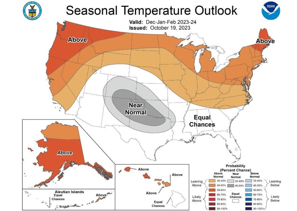
According to NOAA's seasonal temperature outlook, the northernmost states will see above-normal temperatures in February, March and April, especially in New England and the Pacific Northwest. Most of Texas will see below-average temperatures. Warm-weather predictions are in part due to El Niño, a natural climate pattern that sends temperatures soaring.
That bodes well for Punxsutawney Phil's most recent prediction. The National Oceanic and Atmospheric Administration says the groundhog has only gotten it right about 40% of the time.
What will spring 2024 be like in Kentucky?
Tellingly, if you look at NOAA's predictive outlook map, nowhere will you find a spot of blue — temperatures aren't expected to be colder than average anywhere in the country.
Kentucky, NWS forecasters predict, will fare like much of the Midwest with a 35% or greater chance for seeing warmer than average temperatures this year.
We're sick of winter: When's spring already?
What are the dates for the four seasons in 2024?
First day of spring: March 19, 2024
First day of summer: June 20, 2024
First day of fall: Sept. 22, 2024
First day of winter: Dec. 21, 2024
NWS: Latest forecast for Louisville
Here's the latest weather forecast for the Louisville, Kentucky area, according to NWS.
Friday: Partly sunny, with a high near 51. Northeast wind 5 to 7 mph. Friday night: Partly cloudy, with a low around 32. Northeast wind around 6 mph.
Saturday: Sunny, with a high near 52. East wind around 8 mph. Saturday Night: Increasing clouds, with a low around 32. East wind 7 to 9 mph.
Sunday: Mostly sunny, with a high near 55. East wind around 8 mph. Sunday Night: Partly cloudy, with a low around 34.
Monday: Sunny, with a high near 53. Monday Night: Mostly clear, with a low around 31.
Tuesday: Sunny, with a high near 52. Tuesday Night: Mostly clear, with a low around 32.
Wednesday: Mostly sunny, with a high near 56. Wednesday Night: Mostly cloudy, with a low around 41.
Thursday: Mostly cloudy, with a high near 60.
John Tufts covers trending news for the Indianapolis Star. Send him a news tip at JTufts@Gannett.com.
This article originally appeared on Indianapolis Star: National Weather Service in Paducah predicts warmer weather in 2024

