At least 2 people killed and hundreds of thousands without power after tornado-spawning storms hit the Southeast and Ohio Valley
Severe tornado-spawning storms battered the Southeast and Ohio Valley, leaving at least two people dead and more than 400,000 homes and businesses without power as more storms Monday threaten from North Carolina to Philadelphia.
One death was reported after severe storms Sunday slammed Martin County in southern Indiana, emergency management officials told The New York Times. Another person was injured and rescuers were still searching for anyone else who may be in need of assistance, Martin County Emergency Management Director Monty Wolf told the Times.
And in Atlanta, a 55-year-old man died after he was hit by a falling tree during severe weather Sunday evening, police and the local National Weather Service office said.
A a possible twister damaged dozens of homes in Bargersville, Indiana, where residents were warned they could be without power for two days.
Power outages continued to affect a large swath of the South, including more than 90,000 customers each in Tennessee and Arkansas as of Monday afternoon, according to PowerOutage.us. Around 50,000 customers were without power in both Kentucky and Michigan.
As the storm system pushes east, more than 90 million people are under the threat of severe weather Monday. A Level 3 of 5 enhanced risk is highlighted for the mid-Atlantic and Northeast, where multiple rounds of thunderstorms are possible later in the day. Philadelphia, Baltimore, Washington, DC, and Raleigh, North Carolina, are included in the enhanced risk area.
A Level 2 of 5 slight risk area includes New York City, Charlotte, North Carolina, and Columbia, South Carolina, while Boston, Atlanta and Montgomery, Alabama, are under a Level 1 marginal risk. Damaging winds and hail are the main threats through Monday evening, and tornadoes are possible.
Severe thunderstorm watches have been issued from western New York southward to North Carolina for this afternoon into the evening hours.
Very large hail, potentially more than 2 inches in diameter, will threaten the central Carolinas and parts of South Dakota, Nebraska and Wyoming on Monday.
An area from Oklahoma to Mississippi and an area including parts of the Texas and Oklahoma panhandles into New Mexico could see severe thunderstorms Monday, with the main threat being damaging winds.
The storm system on Sunday produced nearly 400 storm reports across a dozen states, including four reported tornadoes, 280 wind reports and more than 100 hail events.
As the storm system moves across the US, thousands of flights were delayed or canceled Monday, according to FlightAware.com.
The storms come as nearly 40 million people from Arizona to Alabama are sweltering under a heat wave which is expected to spread and may continue through the beginning of the July 4 holiday week.
The widespread heat from Arizona through Texas will affect areas in different ways, “with higher air temperatures in the deserts and west Texas and lower air temperatures but higher humidity and heat indices in east Texas, both contributing to a significant risk of heat-related illnesses, especially as the longevity of the heat wave increases,” the Weather Prediction Center said.
The deserts and west Texas are forecast to see temperatures above 110 degrees Monday, while humidity in east Texas will make the air feel warmer than 110 degrees. Some locations could reach – or feel like – 120 degrees.
Extreme heat in Texas already contributed to at least two deaths Friday at the remote Big Bend National Park, where temperatures reached 119 degrees.
The dangerous heat will continue across south-central Texas, while expanding into nearby states in the Central Plains and Middle and Lower Mississippi Valley this week. “Many areas outside south and south-central Texas (will) experience their most significant heat of the season thus far,” the prediction center said.
More than 90 afternoon high temperature records could be set from Texas to the Mississippi Valley and parts of Florida over the next six days. Temperatures will be warm overnight, as well, with potentially 180 record warm low temperatures broken over the next seven days.
“There may be more danger than a typical heat event, due to the longevity of near-record or record high nighttime lows and elevated heat index readings,” the prediction center said.
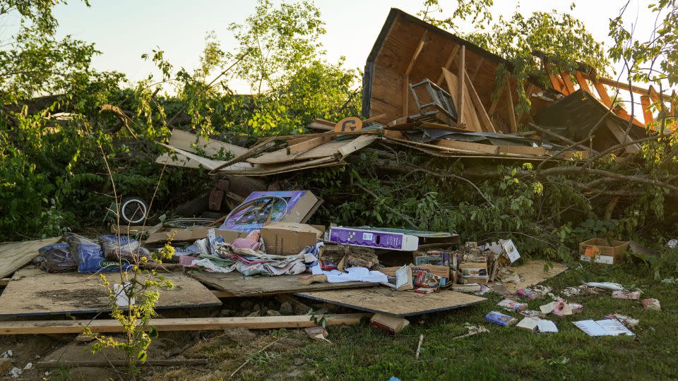
At least 75 homes near Indianapolis were damaged
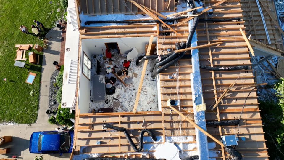
In Bargersville, a severe storm cut a path of destruction roughly three miles long, Bargersville Fire Chief Eric Funkhouser said.
One of the Bargersville Fire houses “witnessed the tornado going just north of the fire house” around 4:15 p.m., then reports began rolling in of homes collapsing and damage throughout the area, Funkhouser said.
At least 75 homes were left with moderate to severe damage “from the tornado being on the ground,” Funkhouser said, adding the storm “took down the apartment complex that was under construction.”
No serious injuries were reported in Bargersville as of Sunday evening, according to the fire chief.
“This is the second tornado to hit Johnson County in the last three months,” Funkhouser said. “It’s amazing to have two tornadoes to come through, that were on the ground for that amount of time in Johnson County and for us to be able to hopefully – once we get through this – find out there were minor injuries only.”
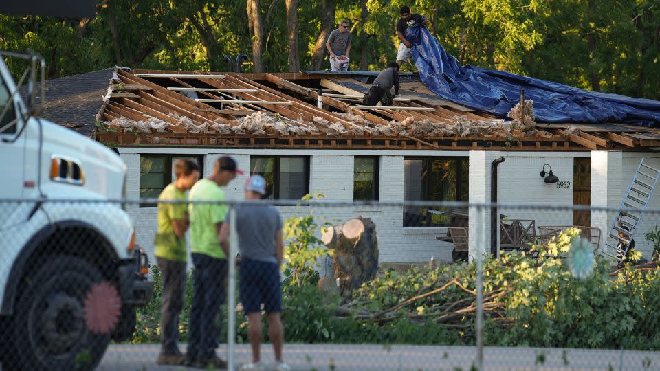
Videos posted on social media showed a funnel-shaped cloud ripping through buildings as debris flew around it. Several houses could later be seen with their roofs ripped off.
“Given the photos and videos that we’ve seen, it’s virtually certain it was a tornado. We will be sending a survey team to make a final determination tomorrow,” National Weather Service Indianapolis Meteorologist Joseph Nield told CNN on Sunday.
Bargersville is about 17 miles south of Indianapolis and is located in Johnson County.
To the south in Tennessee, strong winds toppled trees and damaged structures.

Multiple planes at an airport in Millington, about 17 miles northeast of Memphis, were flipped by the wind, photos from the Millington Fire Department showed. Multiple buildings in the area were also damaged, the department said.
CNN’s Caitlin Kaiser, Michelle Watson, Christina Maxouris, Amanda Jackson, Eric Levenson and Eli Masket contributed to this report.
For more CNN news and newsletters create an account at CNN.com

