Here’s What Hurricane Dorian Looks Like From Space

Hurricane Dorian is predicted to hit the northern Bahamas and parts of the southeastern United States this weekend, unleashing sustained rain and wind speeds tracking around 130 miles per hour, according to the National Hurricane Center.
Storm predictions were dire enough for Florida Governor Ron DeSantis to declare a state of emergency ahead of its arrival.
“It’s important for Floridians on the East Coast to monitor this storm closely,” DeSantis said in a statement. “Every Florida resident should have seven days of supplies, including food, water and medicine, and should have a plan in case of disaster.”
Georgia Governor Brian Kemp also declared a state of emergency in several counties before the storm makes landfall.
There's an increasing likelihood of life-threatening storm surge for portions of the FL east coast late this weekend/early next week, but it is too soon to determine precisely where. Have a plan in place,know if you are in a evacuation zone, and listen to local officials. #Dorian pic.twitter.com/9su9kJE4tE
— National Weather Service (@NWS) August 29, 2019
Hurricanes with winds exceeding 130 miles per hour are classified by the National Hurricane Center as Category 4 — a grouping that often leads to “catastrophic damage.”
“Well-built framed homes can sustain severe damage with loss of most of the roof structure and/or some exterior walls. Most trees will be snapped or uprooted and power poles downed. Fallen trees and power poles will isolate residential areas. Power outages will last weeks to possibly months. Most of the area will be uninhabitable for weeks or months,” the National Hurricane Center explains on its site.
Although it’s too soon to tell what areas are most at risk for direct impact, satellite imagery from the National Oceanic and Atmospheric Administration (NOAA) — the parent agency that includes the National Hurricane Center and the National Weather Service — shows just how massive the storm is at the moment.
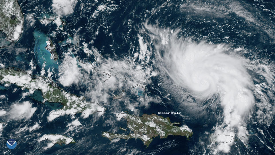
See the dramatic image above, and at NOAA’s website.

