Hurricane Elsa is downgraded to a tropical storm. What could South Florida expect now?
Tropical Storm Elsa was downgraded from a Category 1 hurricane on Saturday, but could still bring flooding, powerful winds and other potential dangers to the Caribbean and Florida as it moves to the northwest.
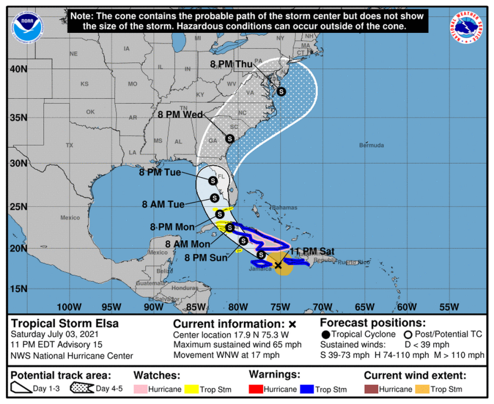
A tropical storm watch is in effect from Craig Key to the Dry Tortugas as potential impacts could reach the Florida Keys by Sunday night or Monday, forecasters said.
The tropical storm warning and watch for the Dominican Republic has been discontinued.
The difference between a tropical storm and a Category 1 hurricane can be slight. A tropical storm packs maximum sustained winds of 39 to 73 mph and turns into a hurricane when the wind speeds reach 74 mph.
So, as the Sunshine State prepares for possible tropical storm conditions, what could happen? Here’s what forecasters say to expect from a tropical storm.
What conditions could you see?
They might fall short of hurricane status, but tropical storms can create plenty of potential hazards to people and their homes.
If tropical storm winds are up to 60 mph, some homes could see damage to their roofs and siding. There’s also a potential that trees could snap, electrical wires could fall and loose objects could move through the air, the National Weather Service said.
In higher tropical storm winds, there’s an additional risk that more houses are damaged, including mobile homes that aren’t well-anchored or have poor construction, forecasters said.
Tropical cyclones — which include tropical storms — sometimes can bring more than 6 inches of heavy rainfall, creating a risk for damaging floods.
“Rainfall amounts are not directly related to the strength of tropical cyclones but rather to the speed and size of the storm, as well as the geography of the area,” NOAA said. “Slower moving and larger storms produce more rainfall.”
Also during tropical weather, forecasters said there’s a potential for rip currents. The channels of water can pull swimmers offshore, making for dangerous beach conditions.
What could happen in Florida?
As of 11 p.m. Saturday, Elsa was about 175 miles south east southeast of Montego Bay, Jamaica and about 205 miles southeast of Cabo Cruz. Its movement had slowed to 17 mph, with maximum sustained winds of 65 mph.
Over the weekend, the storm could impact parts of the Dominican Republic, Haiti, Cuba and the Cayman Islands, The Miami Herald reported.
Forecasters said “gradual weakening is forecast on Sunday and Monday when Elsa is expected to be near or over Cuba.”
July 3 11AM: Tropical Storm Elsa continues to move through the Carribbean. As we move into early next week Elsa will approach South Florida. Here are the latest look at potential threats and impacts for the area #flwx pic.twitter.com/216f7wI00Z
— NWS Miami (@NWSMiami) July 3, 2021
By Monday, Elsa could start to impact South Florida, where potential threats loom.
“While there is a risk of wind, surge, tornado, & rain impacts across south Florida, it’s too early to determine specifics,” the National Weather Service’s Miami office said Saturday afternoon.
In the southern part of the state, areas along the Atlantic Coast could see more than 1 foot of storm surge while totals could exceed 3 feet along the Gulf Coast. Damage to buildings and other structures is possible in places experiencing surge, forecasters said as of 11 a.m. Saturday.
Across the region, flooding could overflow ponds and push water into buildings.
There’s also the risk of isolated tornadoes and strong winds, which can damage homes and leave roads covered in debris, according to the National Weather Service.

