Hurricane forecasters encourage Florida residents to keep an eye on this tropical system
A tropical disturbance expected to move into the Caribbean Sea could pose a threat to Florida as the Labor Day weekend approaches.
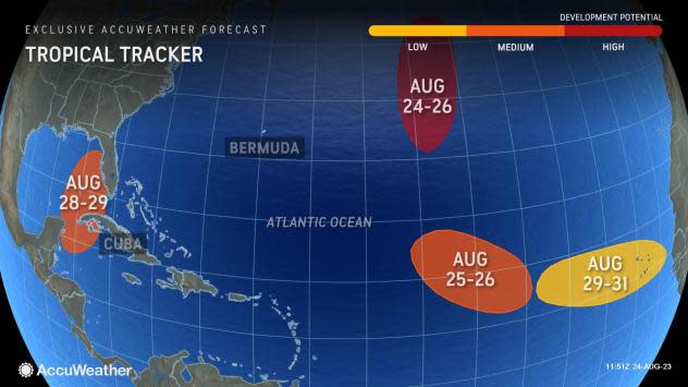
It's just one of several systems being tracked by the National Hurricane Center.
The National Hurricane Center gives the system a medium chance of tropical cyclone development over the next seven days, according to the latest advisory. Forecasters predict it could become a tropical depression as it moves north into the eastern Gulf of Mexico.
The system poses no threat to Florida over the next three to five days, according to the Florida Division of Emergency Management.
"The most reliable models are showing consistent signs for something to evolve and push into the northwest Caribbean this weekend, then possibly the Gulf next week," according to the Florida Public Radio Emergency Network.
The next named storm of the 2023 Atlantic hurricane season will be Idalia.
Where is the tropical disturbance now?

A broad area of low pressure centered over Central America is forecast to move into northwestern Caribbean Sea by this weekend.
Some gradual development of this system is possible thereafter into early next week, and a tropical depression could form while it moves slowly northward, entering the eastern Gulf of Mexico.
Chances for development as of 2 p.m.:
Formation chance through 48 hours: low, 10 percent.
Formation chance through 7 days: medium, 60 percent.
Watching the tropics: National Hurricane Center watching three areas but only Franklin is anywhere near Florida
National Weather Service offices urge residents to monitor tropical disturbance
Several National Weather Service offices around the state have tweeted about the system, warning it bears watching even though "it is too early to speculate what, if any, impact this system might have on Florida."
"Continuing to monitor a system that has potential for tropical development early next week in the Eastern Gulf (50% chance).
"Uncertainty exists, so do not focus on individual model runs. We'll provide updates as they come," said the National Weather Service Office in Tallahassee.
Warm water, low wind shear in Gulf of Mexico could support tropical development
"There is room for a disturbance to move northward from the western Caribbean and into the eastern Gulf during the end of August to the start of September," said AccuWeather Lead Long-Range Meteorologist Paul Pastelok.
Extremely warm water — with temperatures in the 80s and near 90 — and low wind shear could foster the organization and strengthening of the system, according to AccuWeather.
Residents from the eastern Gulf to the southern Atlantic coast, including Florida, "may have to deal with some tropical disturbance or perhaps a more robust tropical system close to the extended Labor Day weekend."
"It’s important to note this potential area low pressure has not started developing just yet," said forecasters with the Florida Public Radio Emergency Network.
"Confidence is usually not high in tropical models tracking a system that does not yet exist, so expect much uncertainty to continue until these signals turn into an actual system."
Have an emergency kit? Here's how to save on hurricane supplies

The second disaster preparedness tax holiday starts Aug. 26. Save on hurricane supplies through Sept. 8.
Avoid paying sales tax on everything from pet food and batteries to toilet paper and trash bags.
Need to restock hurricane supplies? Florida's second tax-free holiday of 2023 is ahead
Conditions and forecasts can (and do) change rapidly
Did you know that the Category 5 hurricanes that have struck the United States were much weaker tropical storms just 72 hours prior? Storms can intensify surprisingly quickly — stay #WeatherReady by being prepared well ahead of time. https://t.co/ktZHW0gzxe pic.twitter.com/RK0vQxGXly
— NWS Owlie Skywarn (@NWSOwlieSkywarn) August 24, 2023
The National Weather Service Owlie Skywarn reported the Category 5 hurricanes that have hit the United States were tropical storms (with wind speeds of 39 to 73 mph) just 72 hours prior to landfall.
We've entered the busiest portion of the Atlantic hurricane season. On average, there is more tropical activity from August through October than the rest of the season, which runs from June 1 through Sept. 30. The peak of the season is Sept. 10.
Remember Hurricane Andrew?
On this day, 31 years ago, #HurricaneAndrew came ashore in southern #Florida near Homestead packing sustained winds of 165 mph and gusts up to 200 mph. Andrew left a trail of devastation across southern Florida, becoming the most costliest hurricane on record at the time. pic.twitter.com/w7UijCb8hu
— NHC_TAFB (@NHC_TAFB) August 24, 2023
On this day, 31 years ago, Hurricane Andrew made landfall near Homestead Air Force Base packing sustained winds of 165 mph and gusts up to 200 mph. near Homestead
It was the costliest hurricane on record at the time.
This article originally appeared on Treasure Coast Newspapers: Tropical depression possible in Gulf of Mexico ahead of Labor Day

